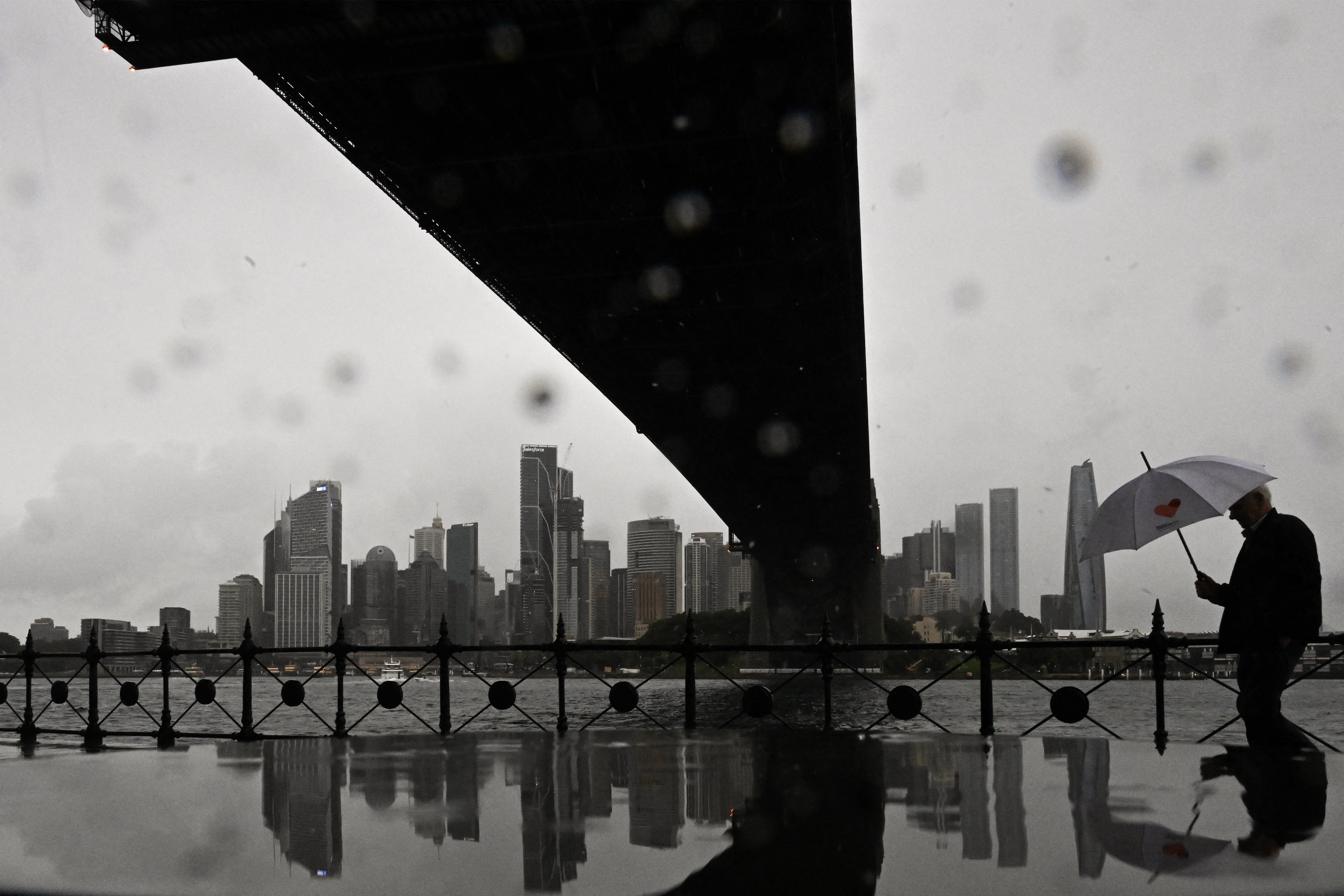
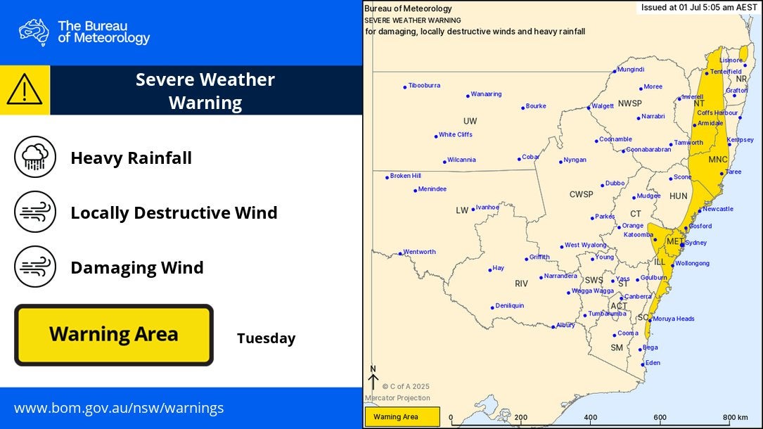
Heavy rain, flash flooding, and 125kmph winds from a destructive “bomb cyclone” continue to create havoc on Australia’s east coast, leaving thousands without power, roads closed and Sydney under flood warnings.
Electricity distributor Ausgrid says power has been restored to 30,000 customers, but about 9,100 homes and businesses remain in the dark this morning.
Major roads are still closed, and ferry and train services continue to face delays and suspensions.
Australia’s Warragamba Dam, the main water supply for Sydney, is approaching full capacity and will likely spill overnight, WaterNSW has announced.
Some suburbs received up to 130mm of rain through the night and severe weather warnings are in place from as far north as Coffs Harbour to the South Coast.
The New South Wales Emergency Service has issued flood warnings for parts of Greater Sydney, with Advice-level alerts now active for Camden, Penrith and North Richmond.
Areas near the Victorian border could also be impacted today as the intense coastal low tracks south, with damaging conditions expected to persist through Wednesday.
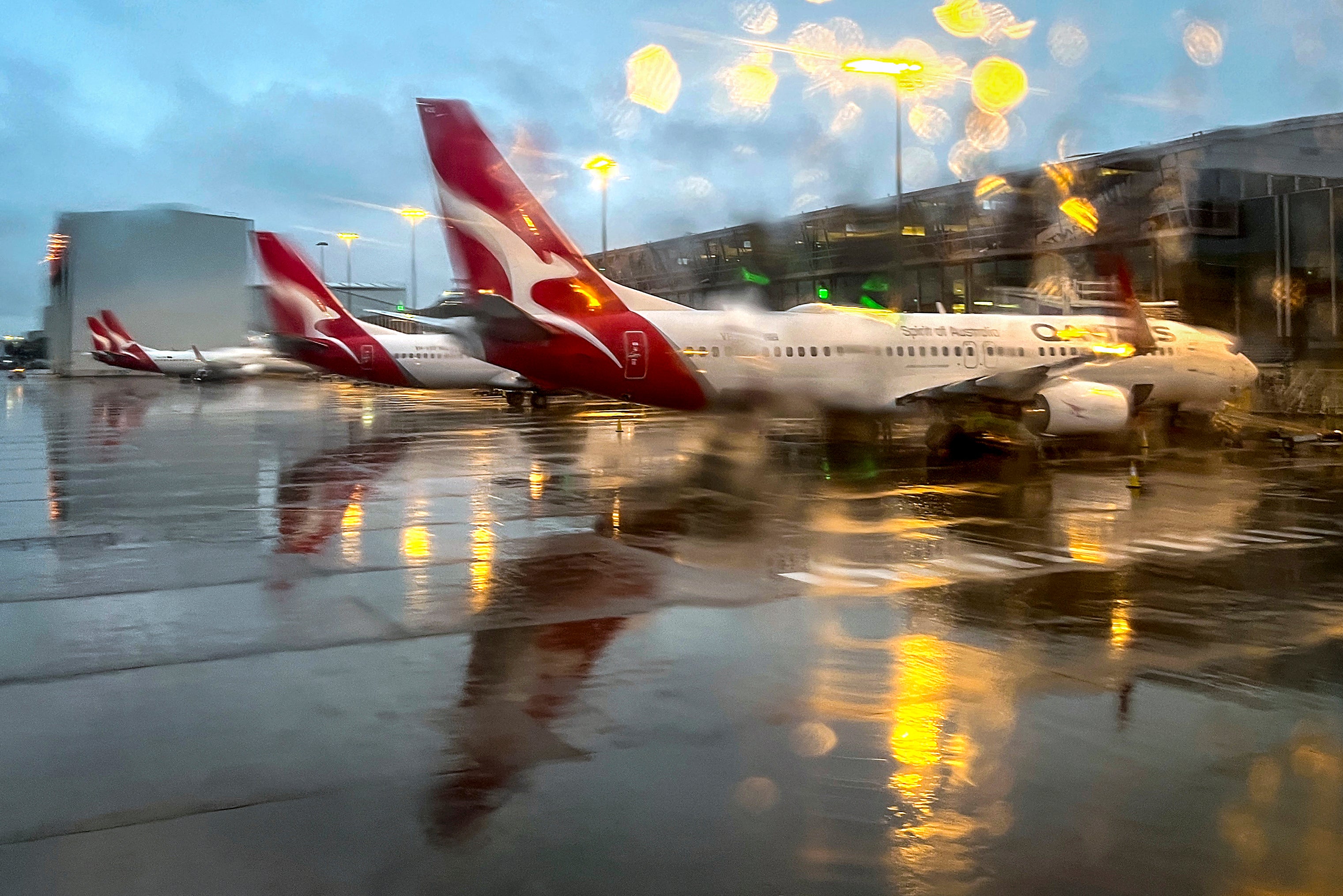
Several domestic flights from Sydney airport including from operators like Qantas and Virgin airlines were cancelled.
Key Points
- Mapped: Flood warnings issued for parts of Sydney
- Power restored to 30,000 customers, thousands still in the dark
- Flights cancelled as storm disrupts Sydney Airport
- ‘Bomb cyclone’ brings extreme rain, floods and damaging winds to Australia’s east coast
- Warragamba Dam, the main water supply for Sydney, will likely spill overnight
Power to most houses to be restored tonight, energy company says
10:15 , Stuti MishraEndeavour Energy, one of Australia’s largest electricity distributors, says it expects to restore power to most customers affected by NSW’s wild weather tonight, with the remaining households back online by tomorrow.
The company, which supplies Western Sydney, the Blue Mountains, the Southern Highlands and parts of the South Coast, said up to 30,000 customers lost electricity during the storm.
“We hope to get over 80 per cent of those customers that are currently affected back on tonight. There will be some customers unfortunately that will be without power tonight, we will get all of them back on tomorrow,” David Campbell, Endeavour Energy’s General Manager of Safety and Operations told ABC.
The storm has left over 400 electrical hazards, and crews are working through difficult conditions to repair damage caused by destructive winds.
Mapped: Flood watches and warnings today
09:41 , Stuti Mishra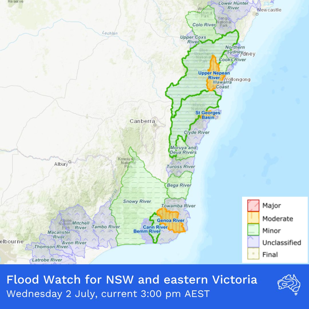
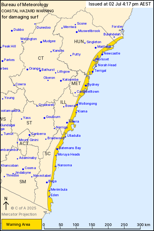
Entire NSW coastline under coastal hazard warning as dangerous surf continues
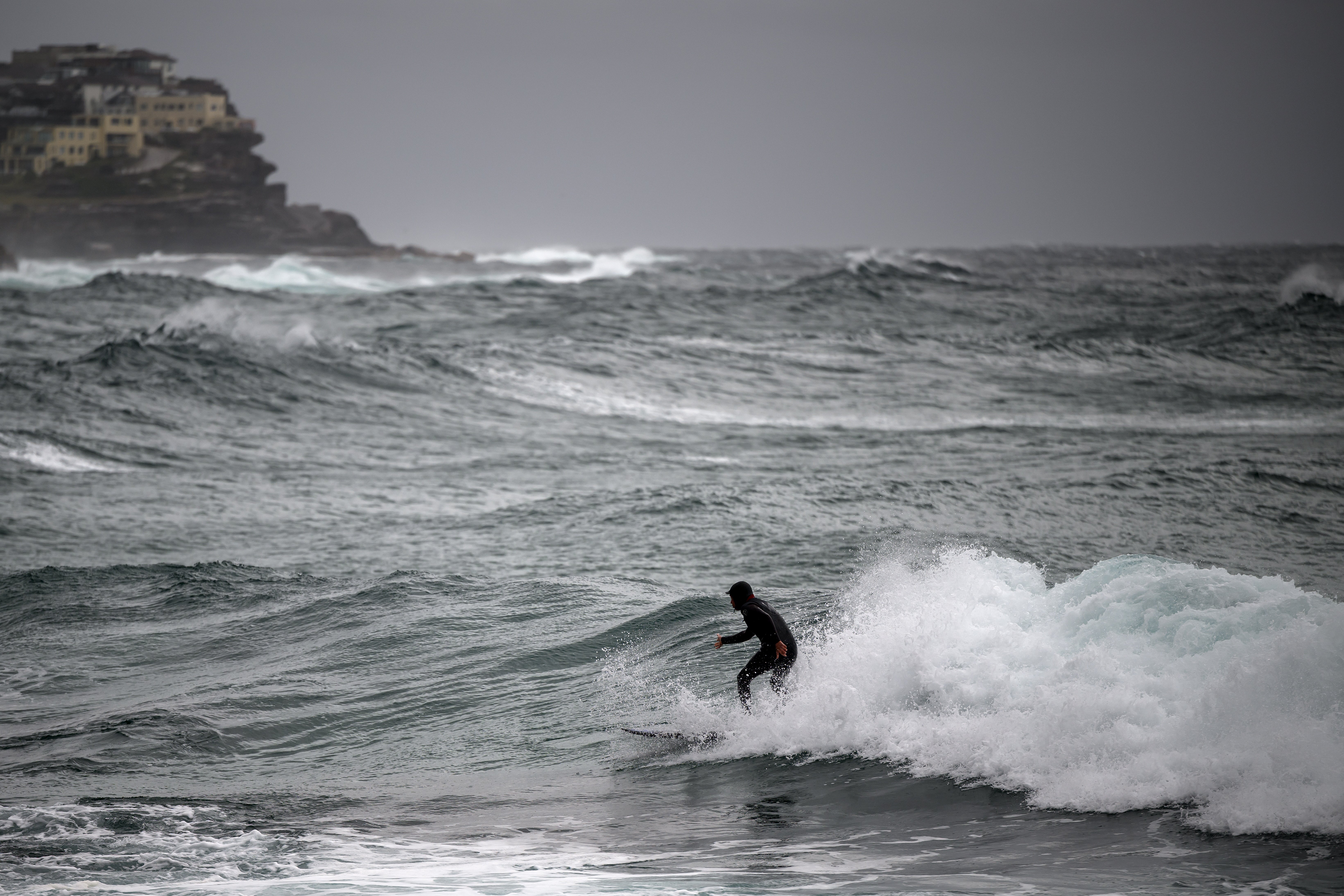
09:10 , Stuti MishraThe Bureau of Meteorology has issued a coastal hazard warning covering the entire New South Wales coastline, from Seal Rocks in the north to the NSW-Victoria border.
In a statement, BOM said: “Damaging surf conditions which may lead to coastal erosion and localised damage to coastal infrastructure are likely for coastlines between Seal Rocks and the New South Wales/Victorian border today and Thursday.”
The agency warned that beach conditions could be extremely dangerous, urging people to stay well away from the surf and exposed areas. Conditions are expected to begin easing on southern parts of the coast tomorrow morning.
Residents and visitors are advised to monitor BOM updates and follow local emergency instructions as the storm continues to generate powerful swells and hazardous coastal conditions.
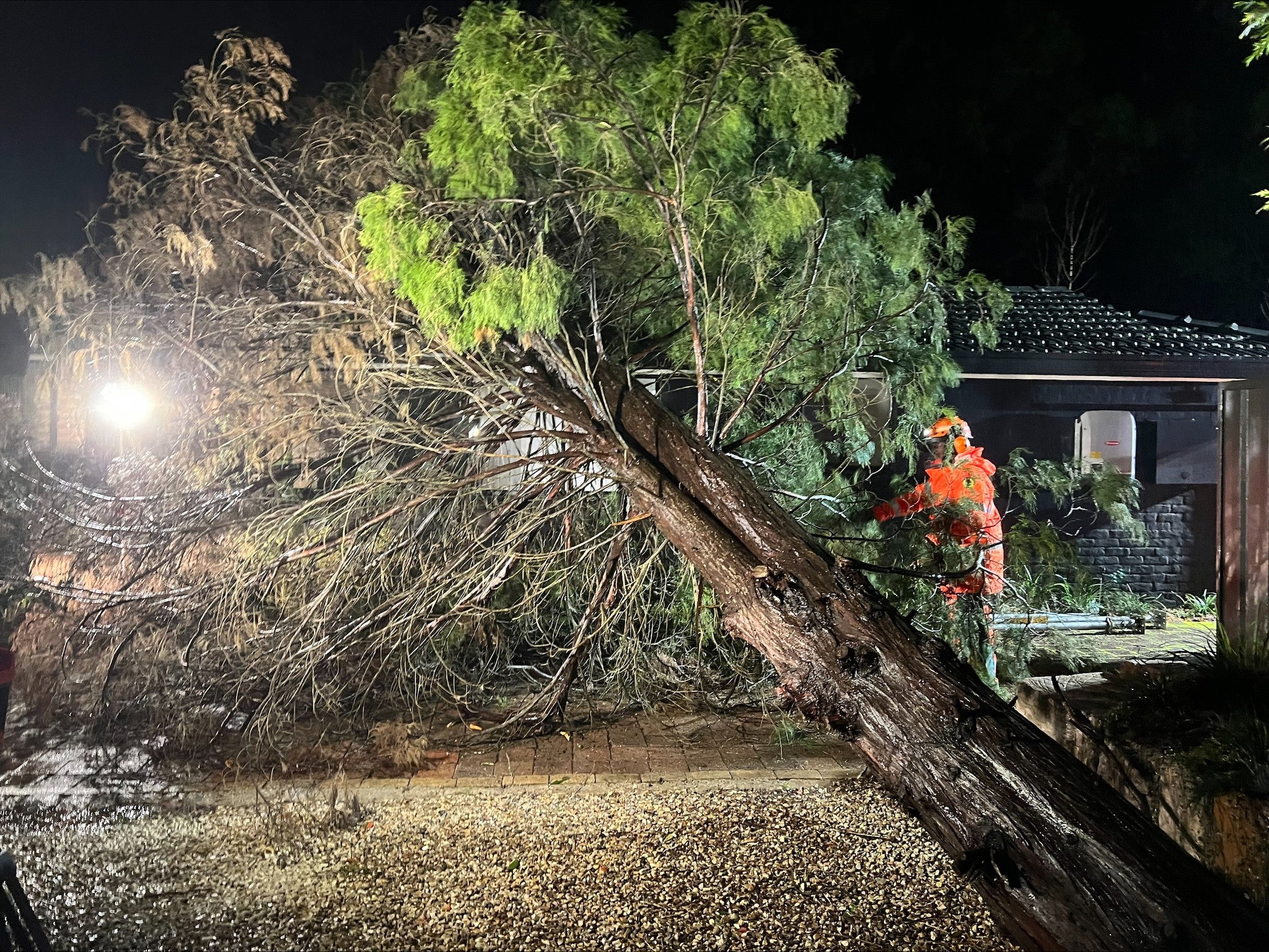
Photos: Waterlogging and fallen trees after heavy rain and winds batter NSW
08:40 , Stuti Mishra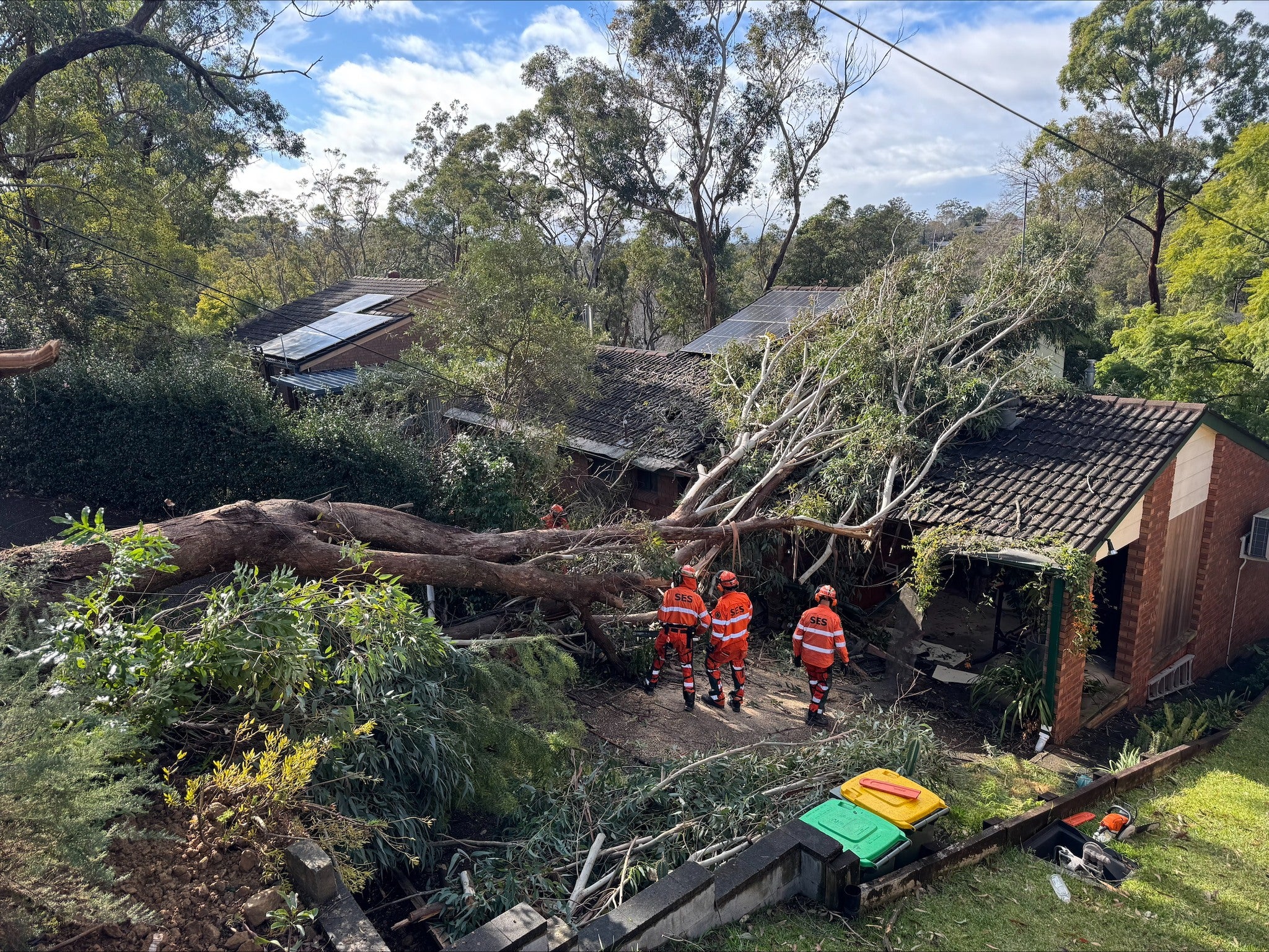
More than 140 Sydney flights cancelled today as storm disrupts travel
Severe weather continues to wreak havoc on air travel, with at least 140 flights in and out of Sydney Airport cancelled so far today. As of midday, boards at Australia’s busiest airport showed 62 domestic departures, 69 domestic arrivals, six international departures and three international arrivals had been axed.
This comes after 145 flights were already cancelled on Tuesday, as powerful winds forced Sydney Airport to operate only its parallel north-south runways, with the east-west runway closed by Airservices Australia for safety. Travellers are urged to check directly with airlines for the latest updates and allow extra time if travelling to or from the airport.
NSW SES has responded to more than 2,400 incidents across the state in the past 24 hours 🦺
— NSW SES (@NSWSES) July 2, 2025
Since the start of the event there have been 3,454 incidents reported and 10 flood rescues.
📲 Stay up to date with warnings via the Hazards Near Me app or the NSW SES wesbite. pic.twitter.com/i2XCxvAhDx
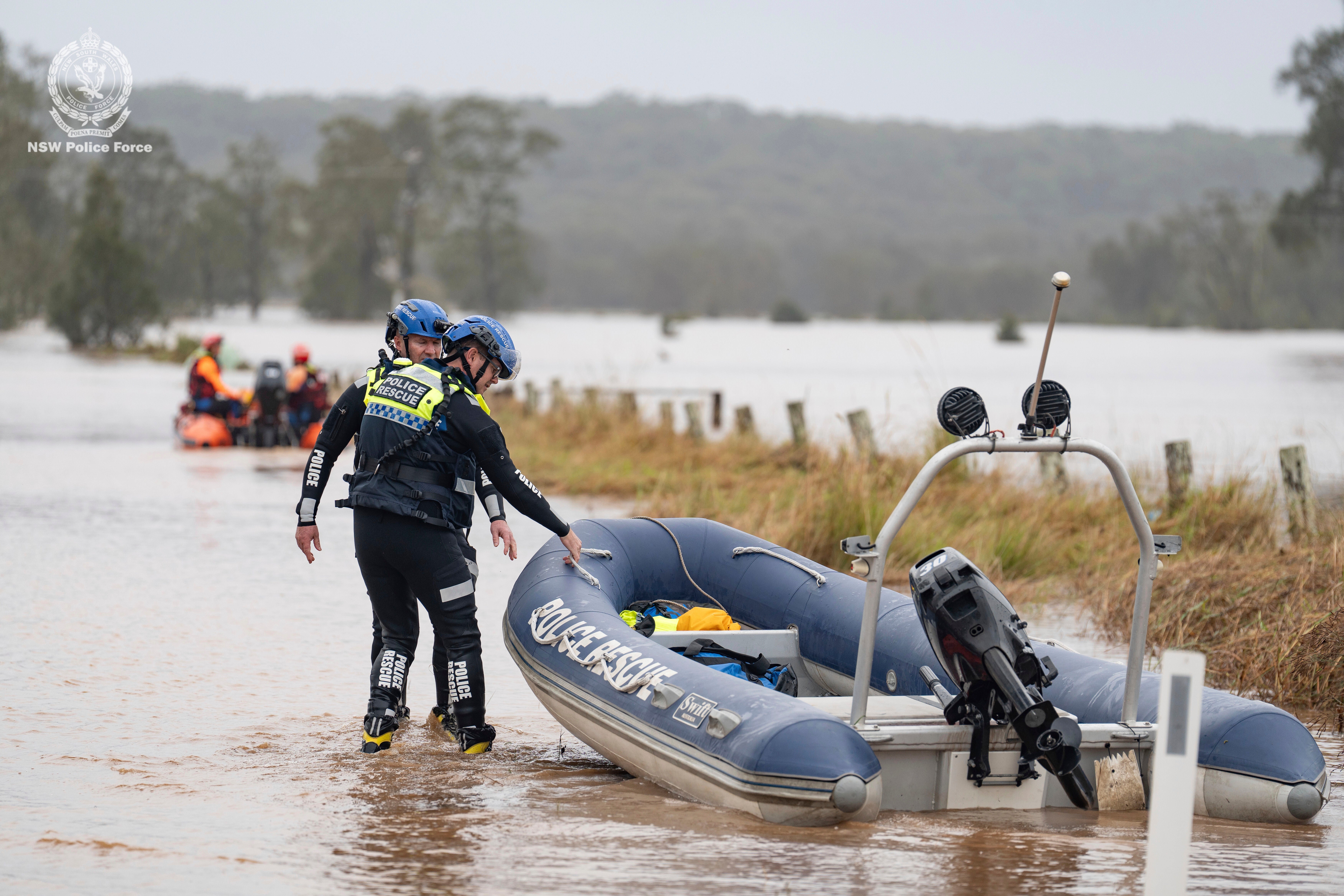
SES responds to thousands of incidents as flash flooding threat grows
07:40 , Stuti MishraThe NSW State Emergency Service (SES) says it has responded to more than 2,400 incidents across New South Wales in the past 24 hours, as the storm continues to hammer coastal communities. Since the severe weather event began, the SES has recorded 3,454 incidents and carried out 10 flood rescues.
“As intense rainfall and damaging winds continue to impact coastal communities, more than 2,000 members have been kept busy overnight and into today attending to requests for help,” NSW SES wrote on Facebook. Crews are currently deployed in Burrill, Tabourie and Lake Conjola, where around 30 properties have been affected by flooding.
The SES warned that “flash flooding remains a key concern today” and said further warnings could be issued for Lake Conjola and Sussex Inlet, with residents in those areas already door-knocked and informed of the risks.
NSW SES has responded to more than 2,400 incidents across the state in the past 24 hours 🦺
— NSW SES (@NSWSES) July 2, 2025
Since the start of the event there have been 3,454 incidents reported and 10 flood rescues.
📲 Stay up to date with warnings via the Hazards Near Me app or the NSW SES wesbite. pic.twitter.com/i2XCxvAhDx
Repeated flooding likely to worsen, experts warn
07:15 , Stuti MishraAs communities in New South Wales face yet another devastating storm, experts say repeated flooding events are becoming more frequent, and more psychologically and financially damaging. Dr Lauren Vinnell of Massey University said: “Any experience of flooding can have harmful psychological impacts, but we know that it’s even worse when people go through multiple events, especially back to back like we’re starting to see more often.”
Climate scientist Dr Daithi Stone said that while it’s complex to directly link individual storms to climate crisis, the warming atmosphere is already making extreme rainfall more intense. “The warming we have already seen equates to about 10 per cent more water. This means we would expect 10 per cent more rain to fall in these types of storms,” he said.
Australia’s Warragamba Dam, the main water supply for Sydney, is approaching full capacity and will likely spill overnight, WaterNSW has announced.
In a statement, the agency said the expected overflow would be “moderate”, with a peak spill rate of around 60 gigalitres per day, though the exact volume depends on how much more rain falls across the catchment today.
Smaller dams near Sydney, including Cataract, Nepean, Cordeaux, Avon and Woronora, began spilling overnight and continue to release water. Fitzroy Falls, Tallowa, Greaves Creek and Medlow dams were already spilling before this storm and remain full.
Warragamba Dam sits about 65km west of central Sydney and holds most of the city’s drinking water. When the dam spills during intense rainfall, it can cause downstream flooding along the Nepean and Hawkesbury rivers, posing risks to communities in western Sydney.
Victoria border communities on watch as storm threatens to shift south
06:17 , Stuti MishraAreas near the NSW-Victoria border could be in the firing line as the destructive “bomb cyclone” continues to batter New South Wales, with thousands of homes and businesses still without power.
Meteorologists and emergency services are warning that if the coastal low tracks further south, intense rainfall and damaging winds could begin affecting communities closer to Victoria later tonight or early tomorrow.
NSW SES deputy commissioner Debbie Platz said the biggest risk area right now is along the south coast, but emphasised that the situation remains dynamic.
“The biggest risk area for us today, as we move forward with the intense rainfall, is on the state’s south coast, particularly around Sussex Inlet, Burrill Lake and Shoalhaven,” she told Today.
“It has been a very wild night … and we are not out of the woods yet. Where we’re most concerned now is the southern flank of this system, which is really impacting the Illawarra region right down to Bega.
We do expect that the rain will intensify, as will the wind gusts. But it doesn’t mean that places like Sydney are out of the woods either.”
Travel chaos continues as 55 domestic flights cancelled
05:50 , Stuti MishraQantas Airways and Virgin Australia, Australia's biggest airlines, have together cancelled at least 55 domestic flights in and out of Sydney today, the airport's website showed. Some international flights have been delayed.
Sydney's train services have also been disrupted, with authorities urging people to avoid non-essential travel.
"Be really careful. It's really wild out there, if you can delay travel, please do so," New South Wales state emergency services chief superintendent Dallas Burnes told ABC News.
"As people wake today and see the damage from last night, we're expecting a very busy day."
Low pressure system seen off the coast of NSW
05:35 , Stuti MishraBOM shares water vapour imagery that shows two circulations for the vigorous low pressure system, also called the bomb cyclone.
Water vapour imagery shows two circulations for the vigorous #LowPressureSystem off the #NSW coast. One is rotating off the #CentralCoast– the primary low pressure system bringing heavy rain and flooding, with a secondary low over the #TasmanSea.
— Bureau of Meteorology, Australia (@BOM_au) July 2, 2025
Latest: https://t.co/4W35o8i7wJ pic.twitter.com/9QrX4Gq30u
Flood warnings issued for parts of Sydney
04:56 , Stuti MishraThe NSW State Emergency Service has issued initial flood warnings for parts of Greater Sydney, with Advice-level alerts now active for Camden, Penrith and North Richmond.
In Camden, the Nepean River is rising and could reach 6.8 metres by tonight, up from its current level of 2.98m. In Penrith, the Nepean is at 1.26m but expected to climb to 3.9m by evening.
Meanwhile, the Hawkesbury River at North Richmond is at 0.57m and forecast to reach 3.8m by early Wednesday. Residents in these areas are urged to keep an eye on warnings here.
.png)
Power restored to 30,000 customers, thousands still in the dark
04:14 , Stuti MishraAusgrid says electricity has now been restored to around 30,000 customers affected by the severe NSW storm overnight and into this morning.
Crews are still working to reconnect power for about 9,100 homes and businesses.
In a statement, Ausgrid warned residents to stay alert for hazards caused by the storm, especially fallen powerlines.
“Always assume they are live and stay at least 8 metres – or 2 car lengths – away from them,” a spokesperson said.

Authorities warn of higher number of emergency calls
Wednesday 2 July 2025 00:01 , Daniel KeaneNew South Wales SES state operations manager Dallas Burnes has reported a rise in emergency calls due to extreme weather.
"We're already starting to see the impacts — 600 incidents responded to in the last 24 hours and over a thousand of our volunteers out helping their communities already," he told Nine's Today programme on Tuesday.
"We are really concerned about flash flooding, particularly around the commute home for people this afternoon, as we see those rainfall figures escalate throughout the day," he warned.
What is a ‘bomb cyclone’?
Tuesday 1 July 2025 23:00A large fall in pressure – about 20 to 30 hectopascals over the past day or two – has transformed the costal low into a severe storm system.
But the Bureau of Meteorology has stopped short of calling the weather system a “bomb cyclone”.
The bureau’s senior meteorologist, Jonathan How, told Nine’s Today program: “We don’t really use [bomb cyclone] very much. We just talk about a low pressure system deepening very quickly because ‘bomb’ can sort of create a little bit more panic and [make it sound] a little bit more scary than what it actually is.”
More than 29,000 homes still without power
Tuesday 1 July 2025 22:00 , Daniel KeaneMore than 29,400 homes in New South Wales are without power as of Wednesday morning, according to ABC.
According to Ausgrid, more than 10,000 customers are experiencing unplanned outages due to fallen trees and broken power lines in the Hunter Valley and Greater Sydney region.
Severe weather to persist on Wednesday, forecasters say
Tuesday 1 July 2025 21:00 , Daniel KeaneThe Bureau of Meteorology says dangerous conditions from the powerful east coast storm will continue through Wednesday, with warnings for damaging winds and large seas still in place.
“Damaging winds and large seas will continue across much of the coast through Wednesday, with warnings expected to continue," senior meteorologist Helen Reid said.
The bureau expects the system to gradually move offshore into the Tasman Sea on Wednesday, with conditions improving later in the week.
“Conditions will continue to ease into Friday with only very light isolated showers lingering about the east coast by the end of the week,” Ms Reid added.
140 Sydney flights cancelled amid wild weather; travel insurance warning issued
08:16 , Stuti MishraAt least 140 flights in and out of Sydney Airport have been cancelled today as severe weather continues to disrupt travel.
Sydney Airport remains on limited operations, using only its parallel north-south runways, with the east-west runway closed for safety. This follows 145 flight cancellations yesterday, just days before the busy winter school holiday period.
A Sydney Airport spokesperson said passengers should “check their airline regarding the status of their flight” as delays and cancellations continue.

Which direction is the coastal low heading?
Tuesday 1 July 2025 20:00 , Daniel KeaneThe coastal low has been detected offshore to the east of Sydney, with people warned to stay indoors and not travel on Wednesday.
Australia’s Bureau of Meteorology said in a statement: “A moist southeasterly airstream is likely to continue strengthening on the southern flank of the system this evening, bringing heavy rainfall through the southern Illawarra, South Coast and adjacent Southern Tablelands.
“Impacts associated with the complex low will likely be on an easing trend during Thursday, but pulses of increased winds and rainfall associated with this system could continue to impact areas of eastern NSW.”
Watch: Coastal residents told to 'evacuate now'
Tuesday 1 July 2025 19:00 , Daniel KeaneSingle runway operation begins at Sydney airport
Tuesday 1 July 2025 18:00 , Daniel KeaneA single runway operation is in place at Sydney airport due to severe weather.
“This decision is purely weather and safety-related to safeguard the travelling public,” a spokesperson said.
“We anticipated this safety call in cooperation with our airline customers and the BOM.
“Airlines and airports were well aware single runway ops were a likely outcome today due to BOM’s inclement weather forecast.”
Weather system expected to shift offshore on Wednesday
Tuesday 1 July 2025 17:00 , Daniel KeaneThe low-pressure “bomb cyclone” system that lashed New South Wales with heavy rain and strong winds is expected to shift offshore into the Tasman Sea on Wednesday and ease by Thursday, Australia’s weather bureau said.
"Damaging winds and large seas will continue across much of the coast through Wednesday, with warnings expected to continue," Senior Meteorologist Helen Reid said.
"Conditions will continue to ease into Friday with only very light isolated showers lingering about the east coast by the end of the week."
Qantas cancels arrival celebrations in Sydney for longest commercial flight
Tuesday 1 July 2025 16:09 , Daniel KeaneQantas has cancelled arrival celebrations at Sydney airport for a commercial flight due to severe weather.
Flight QF6041 had been due to be the longest A321XLR flight operated by a commercial airline, clocking in at 9,600km
“Due to a number of factors, including forecast weather conditions, we sadly need to cancel tomorrow’s A321XLR arrival celebrations scheduled for 10:30am at Sydney’s Hangar 96,” a Qantas spokesperson said.
Climate change and warm oceans may be fuelling storm intensity
Tuesday 1 July 2025 14:30 , Stuti MishraDr Martin Jucker, senior research fellow at the Climate Change Research Centre and the Bushfire and Natural Hazards Research Centre at the University of New South Wales, said the storm’s rapid development and severity are unusual.
“This is an extreme weather event unlike what we usually experience: It develops fast and right next to the coast, bringing heavy rainfall and strong winds — hence the 'bomb' attribute.”
While Dr Jucker said it’s unclear how climate change directly affects the formation of such storms, he said: “It seems safe to say that the current very high water temperatures off the eastern Australian coast would help such systems to become intense by providing the necessary moisture from the warm ocean surface.”
He added that more research is needed to understand why some storms stall near the coast and how they might behave in a warming climate.
Summary: Here's what you need to know about the storm hitting Australia
Tuesday 1 July 2025 14:00 , Stuti Mishra- An intense low-pressure system, also called a "bomb cyclone", lashes Australia’s east coast with forecasts showing up to 200mm of rain, winds up to 125kmph, and dangerous 7m swells.
- Emergency alerts cover communities from Collaroy to Ulladulla for flooding, coastal erosion, and dangerous surf.
- Dozens of Qantas and Virgin flights cancelled; Sydney Airport using one runway due to strong winds.
- Central Coast train services suspended in parts; major ferry routes, including F9 Watsons Bay, not operating.
- About 30,000 customers without electricity, mostly on Central Coast and Newcastle.
- SES (State Emergency Services) orders evacuations in areas facing coastal erosion and flooding, including Wamberal and North Entrance.
- NSW SES warns situation will deteriorate overnight, especially in Sydney, Illawarra and South Coast.
- Heavy rain, strong winds and hazardous surf to continue into Wednesday, easing gradually from Thursday.
Emergency services deployed as storm damage mounts
Tuesday 1 July 2025 13:30 , Stuti MishraMore than 1,200 State Emergency Service volunteers responded to over 1,000 calls for help across New South Wales, as reports of fallen trees, damaged roofs, flooding and power outages surge.
Crews are working through hazardous conditions to restore power, clear roads, and assist residents with evacuations. Authorities are warning that conditions could deteriorate further overnight, with high tide expected to worsen coastal flooding.
Over 20 road closures as storm wreaks havoc on NSW transport
Tuesday 1 July 2025 13:00 , Stuti MishraTransport officials report more than 20 road closures across New South Wales, stretching from north of Sydney to south of Wollongong and inland towards Tamworth and Bowral.
Fallen trees, flooding and debris are making many routes impassable. Drivers are being told to avoid unnecessary trips, obey road closure signs, and never attempt to drive through floodwaters, as emergency services work to clear blocked roads and respond to accidents.
Full story: Australia flights cancelled as bomb cyclone hits New South Wales
Tuesday 1 July 2025 12:40 , Stuti MishraA bomb cyclone sweeping Australia’s east coast has forced the cancellation of dozens of domestic flights to and from Sydney.
Severe weather conditions, including heavy rain and strong winds, have forced major airlines to cut scheduled flights out of Sydney Airport.
Read more:
Australia flights cancelled as bomb cyclone hits New South Wales
Power outages climb to 30,000 as storm batters NSW
Tuesday 1 July 2025 12:15 , Stuti MishraPower outages have increased to around 30,000 customers across New South Wales as severe weather continues to damage infrastructure, Ausgrid has confirmed.
Speaking on ABC Radio, Sam Sofi, Ausgrid’s group executive for safety, delivery and operations, said: “There’s about 30,000 customers without power, with just over half being across the Central Coast and around 13,000 in the Newcastle area.”
He added that while Sydney had been less affected so far – with “only about 1,500 off” – conditions there were also worsening.
“Given the weather’s still continuing, and probably going to continue through the night, probably into the early hours of the morning, unfortunately, the customers are coming off faster than we can put them back on at present,” he said.
He warned many residents could remain without power throughout Wednesday, with some outages likely to extend into the evening as crews struggle to restore electricity amid dangerous conditions.

Video: Wind gusts and large swells in Sydney
Tuesday 1 July 2025 12:00 , Stuti MishraFerries and trains suspended as storm causes major transport chaos in NSW
Tuesday 1 July 2025 11:45 , Stuti MishraSevere storms battering New South Wales have forced the suspension of several ferry and train services, stranding commuters and delaying travel across the state. Train services on the Central Coast line between Fassifern and Wyong have been suspended after a tree fell on overhead powerlines at Dora Creek. Further south, services were delayed earlier in the day when a tree came down near Kiama.
Ferry services have also been hit hard. The F1 route is suspended except for an hourly Manly service, while F9 Watsons Bay Wharf is closed due to dangerous winds, halting ferries between Rose Bay and Watsons Bay.
Speaking to ABC’s Afternoon Briefing, transport for NSW coordinator general Howard Collins warned: “We are anticipating quite a tough night on public transport and the roads are very slow.”
He added: “The combination of strong winds and heavy rain means not only flooding, but trees and other things. We’ve just seen the roof of a restaurant blow away just near Gosford… If you are planning to get home, leave early. Take your time. Don’t leave it till late in the evening because that’s when disruptions occur.”
Mapped: Areas under rainfall and wind warning
Tuesday 1 July 2025 11:27 , Stuti MishraFallen trees spark car crashes on NSW coast
Tuesday 1 July 2025 11:10 , Stuti MishraEmergency services in New South Wales are warning of worsening conditions as powerful winds and torrential rain bring down trees and powerlines across parts of the Central Coast and Sydney.
NSW SES deputy commissioner Debbie Platz told ABC News: “We will see conditions deteriorate even further overnight for Sydney, the Illawarra and South Coast areas.”
Ms Platz said emergency crews were already overwhelmed: “What we’re seeing already are trees and powerlines coming down in some parts of the Central Coast and Sydney. And we have at the moment over 1,200 amazing volunteers and our emergency services partners who are responding at the moment to well over 1,000 jobs.”
She added that around 9,000 customers on the Central Coast were without power as of Tuesday evening, and dangerous road conditions were leading to serious accidents.
“In one instance, for example, there’s a tree that came down in the Lake Macquarie area and that caused a four-car accident. So it’s very dangerous conditions out along the east coast of New South Wales,” she warned.
Tens of thousands without power as storm lashes NSW coast
Tuesday 1 July 2025 10:55 , Stuti MishraTens of thousands of homes and businesses have lost power across New South Wales as powerful winds and torrential rain hammer the state’s east coast.
Ausgrid, which services Sydney, the Central Coast and the Hunter region, confirmed this afternoon that around 18,000 customers were without power as of 4pm, with strong winds and heavy rain bringing down powerlines across its network.
By 5pm, Ausgrid’s website showed 54 unplanned outages affecting 26,797 sites across the Hunter, Central Coast and Sydney coastline.
In a statement, the company said: “Ausgrid crews, including emergency teams, are working around the clock to restore power safely and as quickly as possible. We’re asking everyone to take extra care, especially around fallen trees and storm debris, which may be hiding hazards. If you see fallen powerlines, always assume they are live.”
The NSW SES said the Central Coast is starting to “feel the impacts of the coastal low, with rising incidents and reports of power outages.” Authorities urged people to stay indoors if safe, avoid unnecessary travel, and never drive through floodwater.
What is a bomb cyclone - and why the NSW storm may not be one
Tuesday 1 July 2025 10:41 , Stuti MishraThe powerful weather system lashing New South Wales has been widely described by experts and the media as a “bomb cyclone” because of how quickly it intensified off Australia’s east coast.
A bomb cyclone, or “bombogenesis”, refers to a low-pressure system that deepens rapidly - its central pressure dropping by at least 24 millibars in 24 hours - creating a storm capable of unleashing extreme rain, destructive winds and dangerous coastal conditions.
Several meteorologists have said the current storm has many features of a bomb cyclone, including rapid strengthening and severe impacts. However, Australia’s Bureau of Meteorology has described it as a “vigorous coastal low”, noting it doesn’t meet the criteria for an official east coast low.
Regardless of terminology, authorities are warning of life-threatening conditions across coastal communities, with evacuations underway, widespread power outages and more heavy rain and damaging winds expected into Thursday.
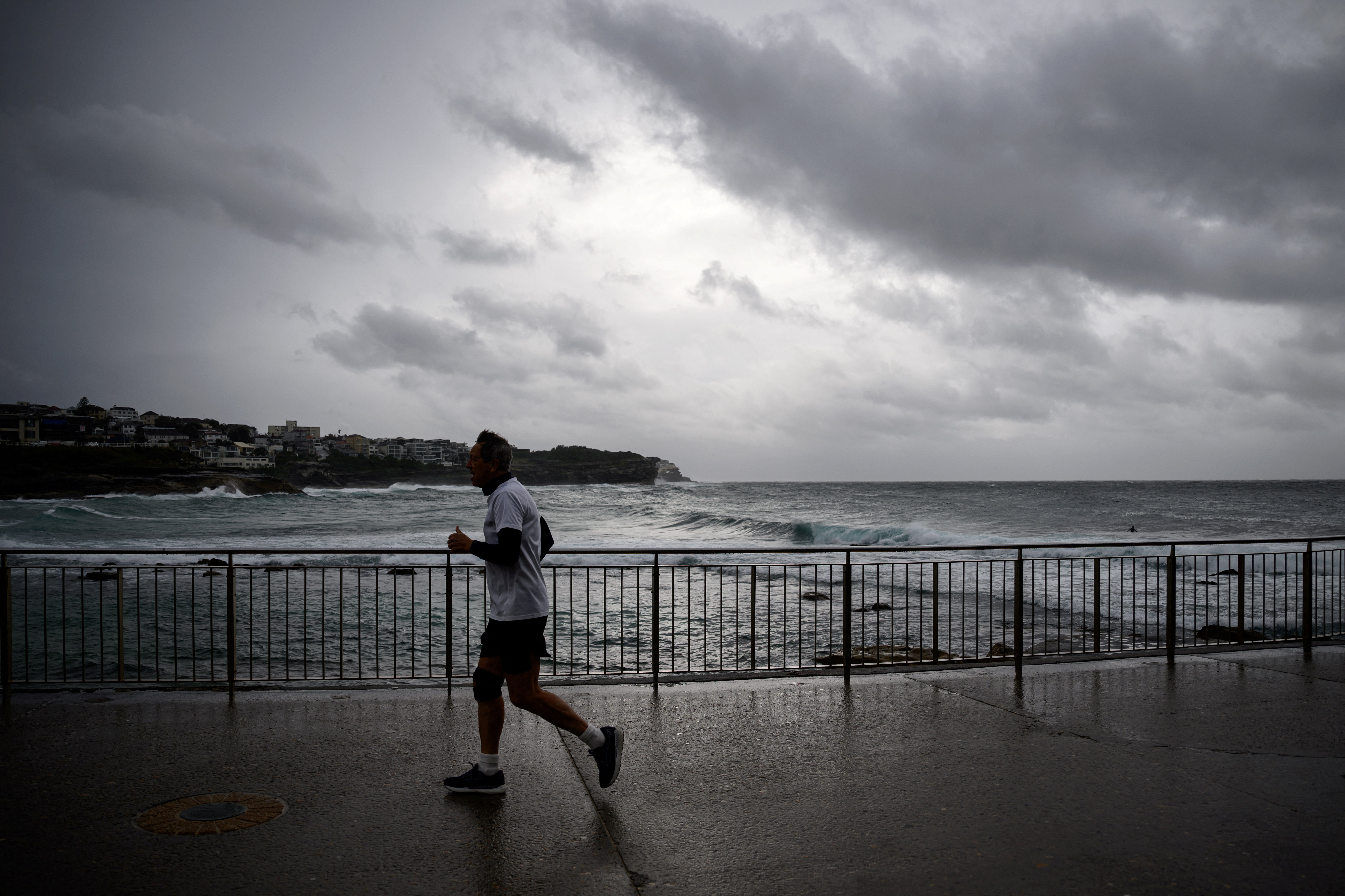
Photos: Large swells seen at beaches
Tuesday 1 July 2025 10:22 , Stuti Mishra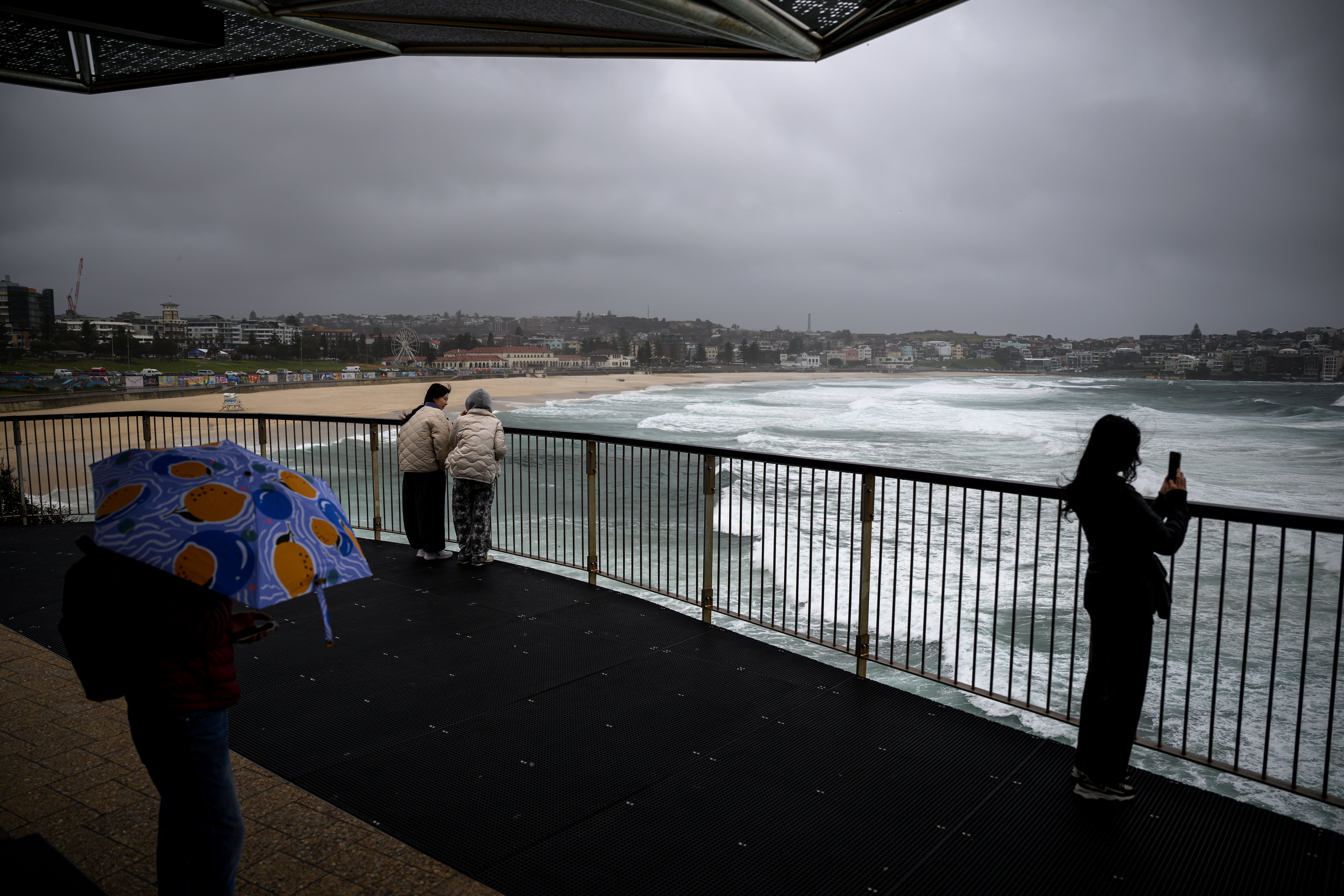
Severe weather to persist tomorrow, easing by Friday, forecasters say
Tuesday 1 July 2025 10:07 , Stuti MishraThe Bureau of Meteorology says dangerous conditions from the powerful east coast storm will continue through Wednesday, with warnings for damaging winds and large seas still in place.
“Damaging winds and large seas will continue across much of the coast through Wednesday, with warnings expected to continue," senior meteorologist Helen Reid said.
The bureau expects the system to gradually move offshore into the Tasman Sea on Wednesday, with conditions improving later in the week.
“Conditions will continue to ease into Friday with only very light isolated showers lingering about the east coast by the end of the week,” Ms Reid added.
Flights cancelled as storm disrupts Sydney Airport
Tuesday 1 July 2025 09:57 , Stuti MishraSevere weather from the powerful “bomb cyclone” lashing Australia’s east coast has forced airlines to cancel dozens of flights out of Sydney Airport.
Qantas has cancelled at least 11 domestic services, while Virgin Australia has grounded 12 flights, according to the airport’s latest updates.
A spokesperson for Virgin Australia said: “Some services on Virgin Australia's network have been impacted by adverse weather in Sydney and Newcastle today.”
While domestic flights have borne the brunt of disruptions, no international flights have been affected so far. Passengers are being urged to check directly with airlines for the latest updates, as conditions are expected to remain hazardous through Wednesday.
'Sheer size' of system is 'enormous', minister says
Tuesday 1 July 2025 09:50 , Stuti MishraNSW Minister for Emergency Services Jihad Dib said the worst was to come over the next 24 hours.
“It may seem pretty bad but the terrible thing is the situation is going to worsen over the course of the next 24 hours, particularly later this afternoon and into the evening tomorrow,” he told reporters.
“We are asking people to be as prepared as they possibly can be. That system stretches as far from the Mid North Coast down to potentially Bega on the South Coast. Just the sheer size of it is quite enormous.”
Emergency evacuations underway on Central Coast as storm batters coastline
Tuesday 1 July 2025 09:34 , Stuti MishraResidents in waterfront areas of Wamberal and The Entrance, north of Sydney, are being evacuated as massive waves and severe coastal erosion threaten homes.
Authorities have issued emergency warnings directing people to leave immediately, warning that dangerous surf is already causing significant damage to beachfront properties.
Emergency services crews have been going door-to-door to alert residents and assist with evacuations.
Officials say a high tide later tonight could worsen erosion, raising the risk of homes collapsing along the coastline.
"We've got a high tide coming in later this evening, in addition, you throw in a bit of the rain and it might not be worth taking the risk [to stay]," emergency services minister Jihad Dib said.
Locals are being urged to stay away from beaches, secure belongings, and follow evacuation routes as advised.
'Stay indoors’ warning as bomb cyclone pummels Australia’s east coast
Tuesday 1 July 2025 09:16 , Stuti MishraResidents across parts of New South Wales have been urged to stay inside as a powerful “bomb cyclone” brings torrential rain and destructive winds to Australia’s east coast.
The NSW State Emergency Service issued urgent warnings late on Tuesday for people in Jervis Bay, Ulladulla and Batemans Bay, where wind gusts exceeding 125kmph are possible overnight.
“Locally destructive wind gusts with peak gusts in excess of 125kmph are possible along the coastal fringe of the Illawarra and South Coast this evening and overnight, roughly between Jervis Bay and Batemans Bay, with this risk easing during Wednesday morning," the SES said.
A severe weather warning to stay indoors also applies to residents on the exposed coastal fringe of the Sydney metropolitan area, particularly between Bulli and Collaroy.
The Bureau of Meteorology forecasts a further 100–200 mm of rain across parts of the Central Coast and Hunter region, with damaging winds expected to persist through Thursday as a powerful “bomb cyclone” batters New South Wales.
Sydney Airport down to single runway as winds batter flights
Tuesday 1 July 2025 12:29 , Stuti MishraSydney Airport has reduced operations to a single runway due to powerful winds gusting up to 125kmph, disrupting dozens of flights.
Airlines have cancelled or delayed many domestic services, with Qantas and Virgin Australia hardest hit. Travellers are advised to check directly with their airlines for updates, as severe weather is expected to continue through Wednesday before easing later in the week.