The Southwest U.S. is facing "significant" risks of heavy rainfall and flash flooding from Tropical Storm Priscilla and another storm system that's set to move in over the weekend, forecasters warn.
Why it matters: Rains from the former Category 2 Hurricane Priscilla are set to lash much of the Southwest, including some of the driest areas of the U.S., and flood watches were in effect for much of Arizona, including Phoenix and Flagstaff, and for parts of Southern California, Nevada, Utah and Colorado.
Moisture associated with Priscilla will lead to a significant heavy rainfall and a flash flood risk across portions of...
Posted by U.S. National Weather Service (NWS) on Thursday, October 9, 2025
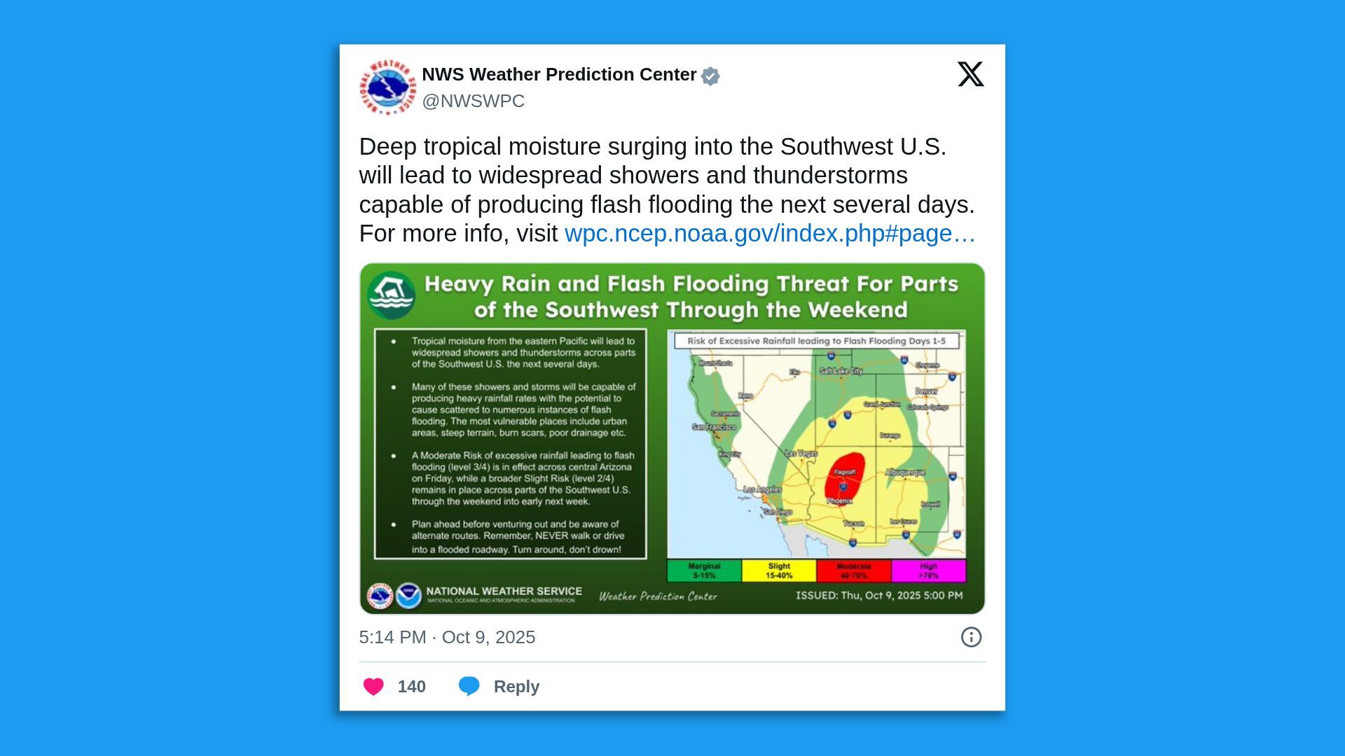
Threat level: "Deep tropical moisture surging into the Southwest U.S. will lead to widespread showers and thunderstorms capable of producing flash flooding the next several days," per a National Weather Service Thursday forecast update.
- The NWS' Weather Prediction Center issued a moderate (Level 3 out of 4) flood risk for Arizona for Friday, including for Phoenix and Flagstaff.
- "Scattered instances of flash flooding will remain possible especially near urban areas, burn scars, and slot canyons," the NWS WPC said.
Zoom in: As Tropical Storm Priscilla moves off the west coast of Baja California, Mexico, the southwestern U.S. faces 2 to 4 inches of rain, according to the National Hurricane Center.
- Local storm total maxima up to 6 inches was expected across portions of central and northern Arizona, southern Utah and southwest Colorado through Saturday.
- The NHC warned flash flooding was "likely in portions of central Arizona, with scattered areas of flash flooding expected across the remainder of Arizona, southern Utah, southwest Colorado, and far northwest New Mexico."
State of play: An "increasingly active weather pattern" is forecast into the weekend, the NWS notes.
- "A broad southwesterly flow setting up ahead of a deep upper-level low centered off the Pacific Northwest will continue to steer moisture originated from Tropical Cyclone Priscilla in the eastern Pacific toward the southwestern U.S.," per the NWS.
- Showers and thunderstorms that developed in the Southwest on Thursday were expected to become more widespread overnight.
- "By Friday, the focus of heavy rainfall is expected to encompass much of the Desert Southwest into the Four Corners region, where a slight risk of flash flooding is forecast," according to the NWS.
- "The heavy rain may become less focused across central Arizona during the day on Saturday as the heavy rain threat pushes farther to the northeast into the Four Corners."
Yes, but: Moisture from Tropical Storm Raymond is set to reach southeastern Arizona later on Saturday.
Between the lines: Climate change is leading to heavier precipitation extremes and related flood risks, multiple studies show.
Go deeper: Rainstorms are getting more intense amid climate change