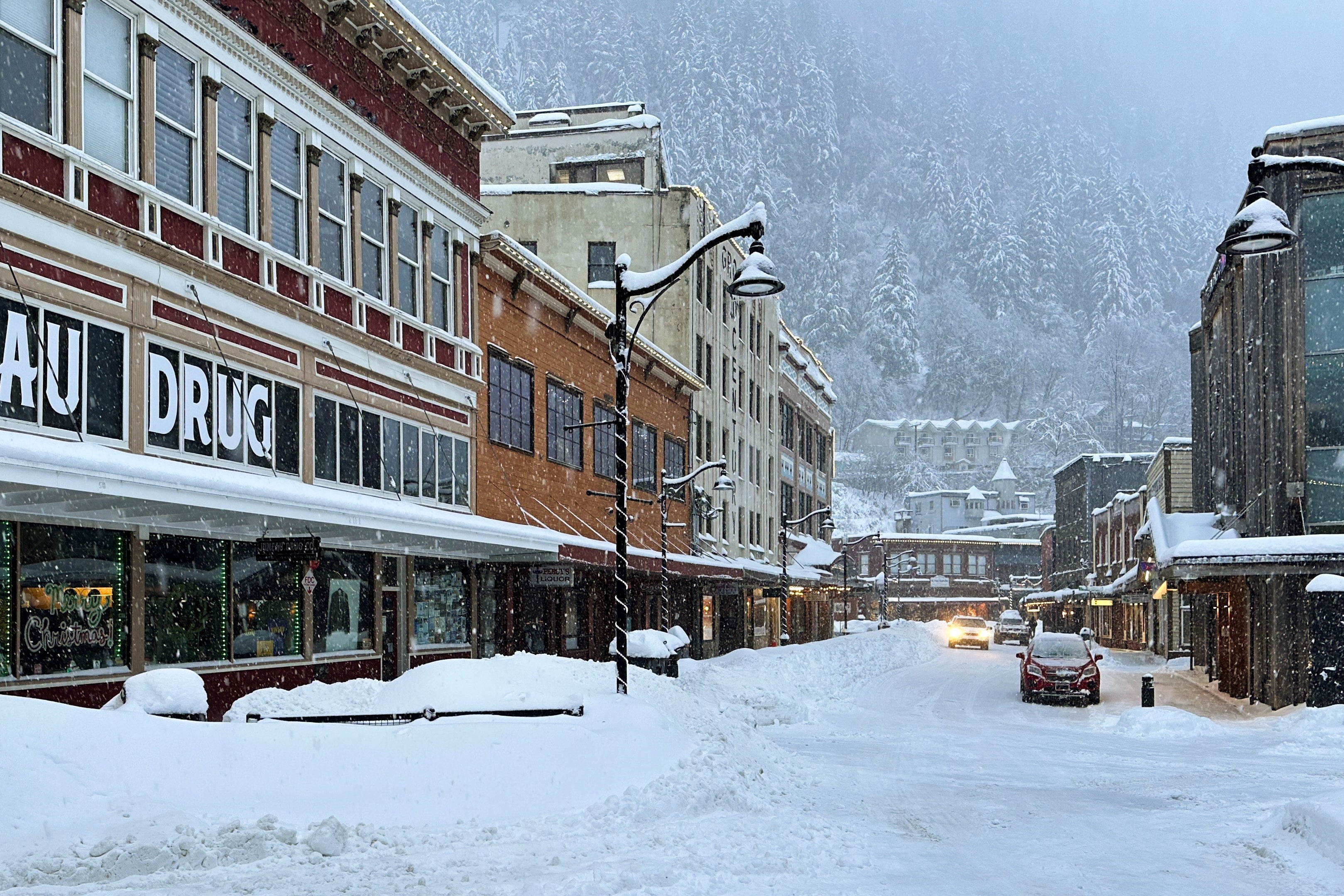
Americans have been warned to avoid unnecessary travel in some areas of the United States as a wild winter storm is expected to bring more strong winds, heavy snow and frigid temperatures.
The nasty weather comes just a day after a bomb cyclone barreled across the northern U.S. and left tens thousands of customers without power.
The storm that hit parts of the Plains and Great Lakes Monday brought sharply colder air, strong winds and a mix of snow, ice and rain that led to treacherous travel. Forecasters said it intensified quickly enough to meet the criteria of a bomb cyclone, a system that strengthens rapidly as pressure drops.
Nationwide, more than 153,000 households were without power early Tuesday, more than a third of them in Michigan, according to Poweroutage.us.
As Monday's storm moved into Canada, the National Weather Service predicted more inclement weather conditions for the Eastern U.S, including quick bursts of heavy snow and gusty winds known as snow squalls.
New York Gov. Kathy Hochul warned that whiteout conditions were expected Tuesday in parts of the state, including the Syracuse-metro area.
“If you’re in an impacted area, please avoid all unnecessary travel," she said in a post on the social media platform X,
Snow piled up quickly in Michigan’s Upper Peninsula on Monday, where as much as 2 feet (60 centimeters) fell in some areas, according to the National Weather Service. Meteorologist Ryan Metzger said additional snow was expected in the coming days, although totals would be far lighter.
Waves on Lake Superior that were expected to reach 20 feet (6 meters) Monday sent all but one cargo ship into harbors for shelter, according to MarineTraffic.com. Weather forecasting on the lakes has improved greatly since the Edmund Fitzgerald sank in 1975 after waves were predicted at up to 16 feet (4.8 meters).
The fierce winds on Lake Erie sent water surging toward the basin’s eastern end near Buffalo, New York, while lowering water on the western side in Michigan to expose normally submerged lakebed — even the wreck of a car and a snowmobile.
Kevin Aldrich, 33, a maintenance worker from Monroe, Michigan, said he has never seen the lake recede so much and was surprised on Monday to spot the remnants of old piers dating back to the 1830s. He posted photos on social media of wooden pilings sticking up several feet from the muck.
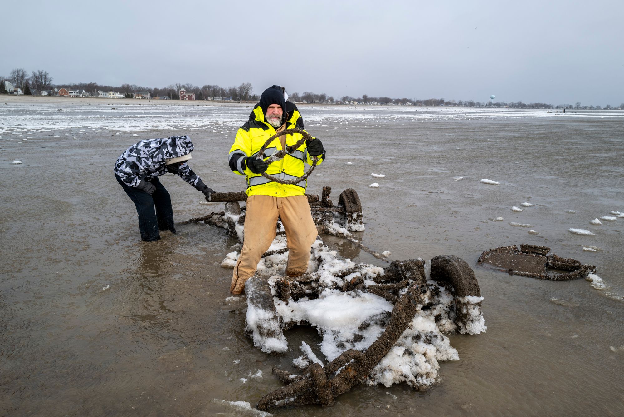
“Where those are at would typically be probably 12 feet deep,” he said. “We can usually drive our boat over them.”
Dangerous wind chills plunged as low as minus 30 F (minus 34 C) across parts of North Dakota and Minnesota on Monday. And in northeast West Virginia, rare, nearly hurricane-force winds were recorded on a mountain near Dolly Sods, according to the National Weather Service.
In Iowa, after blizzard conditions eased by Monday morning, high winds continued blowing fallen snow across roadways, keeping more than 200 miles (320 kilometers) of Interstate 35 closed. State troopers reported dozens of crashes during the storm, including one that killed a person.
On the West Coast, the National Weather Service warned that moderate to strong Santa Ana winds were expected in parts of Southern California through Tuesday, raising concerns about downed trees in areas where soils have been saturated by recent storms. Two more storms were forecast later this week, with rain on New Year’s Day potentially soaking the Rose Parade in Pasadena for the first time in about two decades.
Snow, ice and potential gale-force winds forecast at start of new year
Where wintry showers and ice will hit UK on New Year’s Day
UK set for cold start to 2026 with amber health alert issued
Double murderer’s execution halted over parole board’s ‘conflict of interest’
CIA carries out first drone strike on Venezuelan soil targeting drug gangs
Extreme winds cause 30ft waves on Lake Erie, flooding parts of Buffalo