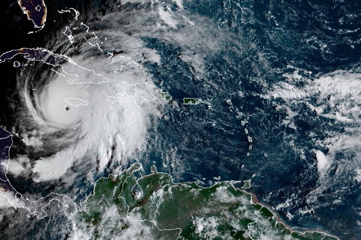
Hurricane Melissa, an intense Category 5 storm, threatened to bring catastrophic winds, heavy rainfall, flash floods and landslides as it tracked through the northern Caribbean and neared landfall in Jamaica on Tuesday. Melissa was then forecast to cross Cuba and the Bahamas through Wednesday.
Here is what to know about the storm:
A record storm for Jamaica
Melissa was a Category 5 hurricane, the highest level, as it neared landfall Tuesday in Jamaica where it was set to be the strongest to hit the island since recordkeeping began 174 years ago.
It is the fifth most intense Atlantic basin hurricane on record by pressure and the strongest to make landfall since Hurricane Dorian in 2019, according to hurricane expert Michael Lowry. It is “a worst-case scenario unfolding for Jamaica,” he said.
The U.S. National Hurricane Center warned the situation is “extremely dangerous” and “life-threatening,” and urged Jamaican residents to remain sheltered until the life-threatening conditions pass.
U.N. agencies and dozens of nonprofits had food, medicine and other essential supplies prepositioned as they awaited a distribution rush after the storm.
Other Caribbean nations at risk
The NHC warned that catastrophic flash flooding and landslides also are possible in Cuba and Hispaniola, the island which Haiti and the Dominican Republic share.
Cuban officials said they were evacuating more than 600,000 people from the region, including Santiago, the island’s second-largest city.
The NHC warned of 5 to 10 inches (13 to 26 centimeters) of rainfall with the potential for flash flooding in the southeastern Bahamas and the Turks and Caicos on Tuesday and Wednesday. Additional rainfall is expected in southern Hispaniola through Wednesday.
Rapid strengthening linked to climate change
Melissa reached tropical storm status last Tuesday and then became a hurricane on Saturday. Melissa then rapidly intensified into a Category 5 hurricane early Monday morning.
Climate scientists have linked warming ocean temperatures to hurricanes intensifying more quickly. Abnormally warm ocean waters of about 2 to 3 degrees Celsius (3.6 to 5.4 degrees Fahrenheit) above normal helped double Hurricane Melissa’s wind speed in less than 24 hours, scientists said.
Rapid intensification occurs when the maximum sustained winds of a tropical cyclone increase by at least 30 knots or 35 mph (56 kph). Warmer temperatures also give hurricanes fuel to unleash more rain.
Scientists said Melissa is the fourth storm in the Atlantic this year to undergo rapid intensification.
Storms that ramp up so quickly complicate forecasting and make it harder for government agencies and nonprofits to plan for emergencies.
___
The Associated Press’ climate and environmental coverage receives financial support from multiple private foundations. AP is solely responsible for all content. Find AP’s standards for working with philanthropies, a list of supporters and funded coverage areas at AP.org.
Hurricane Melissa latest: Jamaicans warned this is ‘not the time to be brave’
UK nationals in Jamaica told to register their presence as Hurricane Melissa looms
Brits locked down in hotels as Hurricane Melissa batters Jamaica
British tourists in Jamaica prepare for strongest storm on record
Prince William ‘pressures Eugenie and Beatrice’ over Andrew’s move: Latest
Netanyahu orders Israeli military to carry out strikes on Gaza immediately