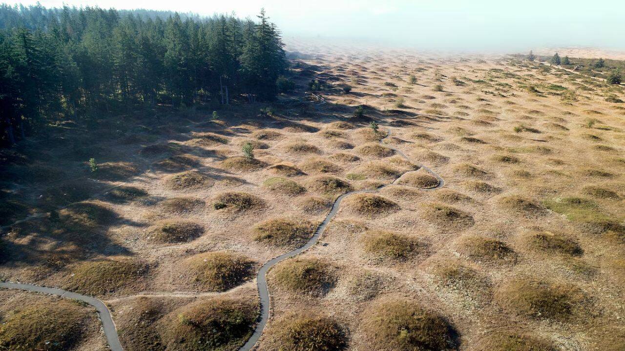
America’s one of the most intriguing geological mysteries: The Mima Mounds of Washington State spread across the Mima Prairie in Thurston County. Hundreds of rounded earthen mounds have puzzled scientists for more than 100 years now, as reported by Discovery UK. But, despite decades of research, experts still cannot agree on how they formed. Some theories point to burrowing gophers, while others credit Ice Age glaciers, ancient floods and even earthquakes. The landscape has attracted geologists, ecologists and curious visitors alike, with new studies continuing to test competing ideas about their mysterious origins.
Get breaking news anytime, anywhere. Download the TOI app now!
Most researchers believe that no single explanation accounts for their size, spacing and widespread distribution. Here's what the Mima Mounds are, the leading scientific theories behind their formation, and why this centuries-old natural puzzle remains unsolved.
What are the Mima mounds and why do they look so unusual
Mima Mounds Natural Area Preserve is a 756-acre protected landscape in Thurston County, Washington, established in 1976 to conserve the state's rare Mima mounds; hundreds of rounded, grass-covered earth mounds whose exact origin remains unknown. The site also preserves one of the few remaining Puget prairie grasslands, along with Garry oak woodlands, oak savannahs and Douglas-fir forests that provide habitat for native plants, butterflies and birds.
The area was designated a National Natural Landmark in 1966 by the National Park Service because of its exceptional geological significance, making it one of only 17 such landmarks in Washington, as reported by the Washington State Department of Natural Resources. Visitors can explore the preserve through an interpretive trail system that includes a half-mile ADA-accessible paved loop and longer gravel paths. Informational displays explain the geology of the mounds, competing theories about how they formed, prairie ecology, wildfire's role in maintaining the landscape and the historical use of the area by Native American communities.
Mima Mounds has also been an active scientific research site. Studies have examined mound formation, prairie vegetation, rare species, fossil insects and ecological restoration. The Washington Department of Natural Resources continues to restore native prairie habitat, remove invasive plants and support wildlife conservation, making the preserve both a valuable research location and one of Washington's most distinctive natural attractions.
Similar landforms exist elsewhere in the world, although they are known by different names. As reported by DiscoveryUK, South Africa has the heuweltjies, parts of California contain features often called hogwallows, and several areas in the southern United States have what are commonly referred to as pimple mounds. They may resemble one another, but that does not necessarily mean they formed through the same process.
How the mystery of the Mima mounds began
People have tried to explain these unusual landforms almost since they were first described by European explorers.
Early visitors often relied on imagination because there was little scientific evidence available. During the nineteenth century, some observers suggested that the mounds might have been burial sites created by ancient communities. Others looked to local traditions that described great floods reshaping the land, offering a very different perspective on how the landscape came to look as it does today.
As geological science developed, explanations gradually shifted away from human activity and towards natural processes. Yet replacing old ideas with new ones did not bring agreement. Instead, each fresh theory solved certain questions while creating others.
What scientists know with reasonable confidence
Although debate continues over how the mounds formed, there is broader agreement about when they probably appeared.
Most geologists place their origin after the retreat of the great ice sheets that covered much of the region during the last Ice Age. As glaciers withdrew thousands of years ago, they left behind fresh sediments and dramatically altered the surrounding landscape. The Mima mounds are generally thought to have developed sometime after this period rather than before it.
That timeframe narrows the possibilities but does not identify the exact mechanism responsible. The challenge is that no single process fully explains the size, spacing and widespread distribution of the mounds.
The Mima mounds gopher hypothesis and the evidence behind it
Perhaps the best-known explanation involves an animal that is rarely seen above ground.
The gopher hypothesis argues that generations of burrowing rodents slowly transformed the landscape over an exceptionally long period. As the animals dug their underground tunnels and nesting chambers, they repeatedly pushed soil towards the surface. Over centuries, and eventually millennia, these small movements may have gradually created the rounded mounds seen today.
Supporters of the idea point to the territorial habits of gophers. Individual animals generally keep a distance from neighbouring burrows, producing spacing that bears some resemblance to the pattern found across the prairie.
The difficulty lies in scale. Many scientists question whether creatures of this size could realistically move enough material to produce such extensive landforms without additional natural forces helping the process along.
How Ice Age glaciers may explain the Mima mounds
Some theories look much further back, to a time when glaciers still covered the region.
One proposal suggests that depressions formed on the surface of melting ice as sunlight created shallow hollows. Water flowing across the glacier carried sediment into these pockets. When the remaining ice eventually disappeared, the accumulated material stayed behind as rounded mounds.
Another explanation focuses on frozen ground rather than surface ice. During colder conditions near the edge of retreating glaciers, permanently frozen soil may have cracked into geometric patterns. Ice filled these openings before later melting away as temperatures increased, leaving raised ground behind.
Both ideas connect the mounds to ancient glacial environments, though neither has been able to account for every feature observed across the prairie.
Earthquakes and ancient floods have also entered the debate
Some researchers have suggested that powerful seismic activity could have rearranged loose sediments beneath the surface.
According to this interpretation, earthquake vibrations might have concentrated soil into repeating patterns as energy travelled through the ground. It is an unusual concept, but one that attempts to explain the regularity seen in many mound fields. Others have looked instead at the movement of water.
Large floods during the closing stages of the Ice Age may have transported enormous quantities of sediment before depositing it across the landscape. One version links the mounds to floodwaters released from an ancient glacial lake, while another suggests that flowing water accumulated material around vegetation, gradually creating raised patches that remained after surrounding sediment was washed away.
Flood stories also appear in the traditions of Indigenous communities from the region. While these accounts belong to cultural history rather than geological science, they reflect how striking the landscape has always appeared to those who lived alongside it.
Why the answer remains uncertain
The greatest obstacle is that every explanation fits some observations but leaves others unresolved.
Animal activity helps explain the spacing of certain mounds but struggles with their sheer volume. Glacial theories match the timing yet cannot account for every distribution pattern. Earthquake models remain difficult to verify, while flood-based ideas do not fully explain why similar landforms appear in places with very different geological histories.
Adding to the challenge is the existence of mound fields across several continents. Although they look alike, scientists increasingly suspect that these landscapes may not share a single origin. Similar shapes can develop through entirely different natural processes depending on local conditions.