The latest round of wet weather is sweeping the country, exacerbating inland flooding today before putting a dampener on the east coast's National Day of Mourning tomorrow.
"As many Australians know, the Bureau [of Meteorology] declared a La Niña event the other week, and this is very much looking like a manifestation of the increased rainfall that we were expecting," Jonathan How, senior forecaster at the Bureau, said.
This latest low-pressure system and cold front duo made its way across Western Australia without ruffling too many feathers earlier in the week. But the system has been powering up.
"It has started to draw down a little bit of tropical moisture from off the Queensland coast," Mr How said.
"That's really helped to invigorate the rainfall that we're expecting to see."
After widespread rain and storms in South Australia yesterday, today is expected to be the wettest day for inland New South Wales and Queensland.
"We can expect fairly widespread thunderstorms, which may tend severe for parts of northern New South Wales into southern Queensland, and plenty of showers and rainfall for Victoria as well," Mr How said.
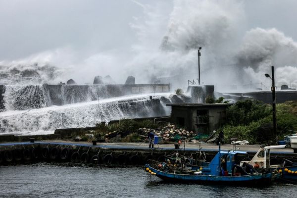
Further flooding for inland rivers
The heaviest falls are expected to be across the inland parts of NSW, particularly the north-west and central slopes, including locations like Parkes, Young and Narrandera.
After widespread rain in the South Australia, Victoria and New South Wales border region yesterday, including 36mm in Renmark, more is on the way today.
Widespread falls of 15 to 30mm are expected for north-west Victoria, inland NSW, and southern Queensland.
Of course, there could be more if you find yourself under a storm.
"We could see six-hourly totals of 60 to 70 millimetres, which could cause flash flooding," Mr How said.
But the big risk tomorrow is the likely exacerbation of major floods already underway in inland NSW and southern Queensland.
"We have seen the floodwaters move through places like Gunnedah, Dubbo, Tamworth, Wee Waa in the past couple of days," Mr How said.
"The rivers really haven't had a chance to come down after the previous rainfall events and this rainfall is just basically going to exacerbate the flooding that's already there and start to see those rivers rise even further."
Wet for the east coast on Thursday
By Thursday, the rain is expected to push across to the coast, in a depressingly similar set-up to what we saw time and time again last wet season.
Mr How says there is the potential for heavy falls along the coast and the risk of flooding for some coastal rivers.
"The cold front will weaken into a trough but the high-pressure system over the Tasman Sea will block it from moving off too quickly," he said.
They are keeping a close eye on where exactly the low and the trough rest, just a few kilometres in its position can have a big impact on rainfall.
"There is a risk of heavy falls, depending on where that trough is, anywhere from South Coast, Illawarra, Hunter up into the Mid North Coast," Mr How said.
But to be very clear we are not looking at a Lismore 2.0 on the east coast this week.
"Definitely not," Mr How said.
"We are not expecting those triple digits, like what we saw in Lismore.
"But, of course, the forecast heading to spring and summer is that we can expect above average rainfall generally."
The system is expected to get a wriggle on on Friday but it is likely to be showery in its wake.
"So it's looking like quite a showery run heading into the long weekend for Sydney and the coast," Mr How said.
There is a chance of showers all the way into next week.
Canberra will catch the edge of the showers, but away from the east coast it should be mostly dry.
Perth and Adelaide are looking partly cloudy, Melbourne should be mostly sunny, Hobart is expecting a sunny morning although clouding up in the afternoon and Darwin is Darwin: Sunny and 35C.
Showers for the bounce
Saturday morning in Melbourne is looking cool and cloudy with the chance of showers. But with a bit of luck things will clear up for the AFL grand final.
"The bulk of the showers are moving through by the afternoon, there is still a chance of a shower or two at the bounce," Mr How said.
"If you are heading to the game, bring a jacket.
"It is Melbourne, there will be those cool southerly winds, especially if you are heading down from Sydney."
But by the time it is all over the only wet stuff of concern should be the champagne or the tears.
Hot in the tropics
The other weather to watch is the record high temperatures in the north.
"Maximum temperatures right across the north centre of the country are looking 2 to 5 degrees above average," Mr How said.
Weipa at Cape York hit 38.4 degrees Celsius on Monday — that's the highest September day in 30 years of record keeping.
And a number of other locations about the western Top End and Western NT have set early-season maximum records.
It reached 40.7C at Argyle and Rabbit Flat, 40.5C at Kununurra and 38.2C at Tennant Creek, which has 54 years of records.
"Definitely hot. I'm sure people are looking forward to the start of the wet season," Mr How said.