Temperatures are expected to soar across Britain this week with a chance of thunderstorms after a cooler start to June than expected.
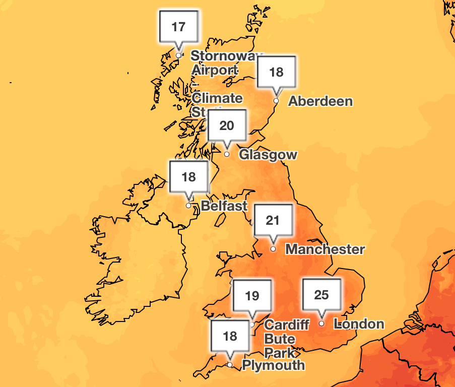
The Met Office has forecasted peaks of 25C on Friday this week in southeast England as temperatures gradually increase across the country.
Newcastle will see balmy 22C heat while York experiences 23C of warmth. Temperatures in Scotland will rise to 21C on towards the end of the week in Berwick-Upon-Tweed, while the rest of the nation will experience warmth averaging in the late teens and early twenties.
The remaining drizzle from last week is expected to gradually clear over the week as the climate begins to feel warmer and more humid, particularly in the South. Rainy spells in the North will gradually clear on Tuesday for bright skies, but thundery showers are expected to move northwards during Thursday and Friday.
The Met Office said “temperatures are on the rise” as the weather is set to remain “changeable” over the next few days.
Meteorologist Craig Snell said that a plume of warm air from Iberia and France brought along the chance of thunderstorms with its humidity.
He added: “After Wednesday, we start to draw up some very warm and humid air from Iberia and France, and that will make it quite humid across much of the UK and that humidity will potentially spark off some thunderstorms.
“From late Wednesday and especially into Thursday, we start to see the risk of some thunderstorms around and that will continue as we go through Thursday and Friday and potentially into Saturday as well.
“By the time we get to midweek, it will feel very different out there, with quite humid night times also becoming a good deal warmer than what we have been experiencing over the last couple of nights, so probably borderline uncomfortable for some people by day.”

The humid weather follows on from the UK’s warmest spring on record, and the driest in more than 50 years, according to provisional Met Office figures.
Provisional figures showed this spring’s average temperature of 9.5C was above the long-term climatological average by 1.4C.
Met Office scientist Emily Carlisle has said: “The data clearly shows that recent decades have been warmer, sunnier, and often drier than the 20th century average.
“This spring shows some of the changes we're seeing in our weather patterns, with more extreme conditions, including prolonged dry, sunny weather.”
Today:
After a bright start, skies will turn increasingly cloudy through the day. Rain will spread in from the west, moving across Northern Ireland, Scotland and parts of northern England and Wales. Staying dry and warm in the South.
Outbreaks of rain will continue in the North at first, but will gradually clear to the east in the early hours. Dry and cloudy in the south and increasingly windy.
Tuesday:
Cloudy for most at first on Tuesday, but skies will gradually brighten across northern areas. Cloudier in the south with drizzly showers, but also feeling humid, warm and breezy.
Wednesday to Friday:
Turning increasingly warm and humid, and feeling hot in the south. Plenty of dry and fine weather, but thundery showers will likely move northwards during Thursday and later on Friday.
As the UN Ocean Conference opens in France, a push to turn promises into protection
Nurses to vote on pay deal amid concerns of industrial action
Oyarzabal gives Spain 2-1 halftime lead in Nations League final against Portugal
Professor accused of faking poor IQ test to boost £1m brain injury compensation claim
Prince William calls for urgent action to save oceans ‘diminishing before our eyes’
Why a bat in the attic could see home improvement costs go through the roof