What we learned this morning, Friday 26 January
We’re going to wrap up this live blog for now. Here are the key points:
Cyclone Kirrily was downgraded to a category-two system about 10pm last night as the centre of the storm crossed the coast between Townsville and Ingham
Queensland premier Steven Miles says there has been no loss of life and minimal damage to property
64,000 homes and businesses are without power, with that number expected to rise today
The system is moving west and emergency services say their focus has turned to the heavy rain and flooding that may occur over coming days
In New South Wales, morning temperatures in some areas have reached the low to mid 30s. Tocal, north-west of Williamtown in the Hunter region, was the state’s hottest place this morning at 36C. Temperatures in several parts of the state are forecast to reach the high 30s and low 40s.
This isn’t the end of our cyclone coverage, though, any updates throughout the day will be found in our continuing live news blog:
Updated
Flood warnings
Flood watch warnings remain in place for coastal and inland catchments between Tully and Airlie Beach, as well as parts of the central west and gulf catchments.
The Bureau of Meteorology has advised minor to major riverine flooding will be possible across those areas as the system moves west over the coming days.
The BoM said the system had “an extreme amount of moisture” which would produce heavy rainfall and could lead to life-threatening flash flooding and damaging winds.
A “continued monsoon” would remain in far north Queensland for the latter part of next week, BoM said.
Updated
Help offered on clean-up costs
Queensland’s new disaster recovery minister, Nikki Boyd, said the government would be seeking funding applications for local government areas affected by the cyclone, including Hinchinbrook, Palm Island and Townsville.
She said those funds would assist the local governments with disaster preparedness, as well as any clean-up costs.
Interstate and state emergency personnel remain on the ground to respond to any SES calls as well as to monitor any potential flooding as the system moves inland.
Updated
The Queensland premier, Steven Miles, said Cyclone Kirrily might have passed but far north Queensland is not out of the woods yet.
The system will continue to move west towards the border over the weekend and into early next week, according to the Bureau of Meteorology.
The state disaster coordinator, deputy commissioner, Shane Chelepy, said Georgetown residents on the Etheridge River would be doorknocked and warned about the risks of the rising river.
“We have sufficient aviation fuel, food water for those communities to sustain those communities. And we also have some appropriate plans in place to continue that resupply over the next coming weeks,” he said.
Queensland’s emergency services say the focus now turns to the coming days as the weather moves west.
Rain and flood waters could cause some communities to be cut off in coming days but the government says communities are well prepared.
Murray Watt the federal minister for emergency management says “we’re not out of the woods yet with this possible flooding”.
Steve Miles press conference
Queensland premier Steven Miles has been speaking. He says it has been a “tense” night but no lives have lost and there is minimal property damage.
The worst impacts have been on energy networks, he says,with 64,000 homes without power.
The Bureau of Meteorology says the system will continue to move further west.

Updated
Townsville resident counts her blessings
Maria spent the days before Cyclone Kirrily frantically removing bamboo and trees from her home in Kirwan in the western suburbs of Townsville.
She moved to the property from Melbourne in 2014 and wanted to make sure she was prepared for her first cyclone:
We hired a large trailer to remove 13 metres of dwarf bamboo and eight metres of heliconias ... If we didn’t cut them down, I reckon we would now be picking it all up.
Maria is one of the lucky ones – she hasn’t lost power and had no damage to her home. But she says she now understands how “scary” Cyclone Yasi was back in 2011:
It does worry me what the actual category-three would feel like.
Updated
Water warning
Townsville residents have been urged to conserve water amid extensive power outages affecting water sites across the region.
The Townsville disaster management group said work was under way to address the situation in the aftermath of Cyclone Kirrily.
Updated
‘We’re going to see those temperatures climb’
Gabrielle Woodhouse says the source of all that heat is an air mass that is moving across the state. The unusually warm morning temperatures have also come off the back of a warm night for most of NSW:
From here on in we’re going to see those temperatures climb into the afternoon.
Some of the hottest temperatures into the high 30s and low 40s are expected in the Sydney, Central Coast, Hunter and mid-north coast regions as well as northern inland NSW.
Updated
NSW feels the heat
It’s not yet 10am in NSW and much of the state is heating up, with extreme temperatures expected in some areas later today.
Temperatures have reached 32C at Sydney Observatory Hill and 34C in Richmond.
Gabrielle Woodhouse, a meteorologist at the Bureau of Meteorology, says the hottest parts of the state right now are in the Hunter region, with several locations already hitting temperatures in the mid 30s. Tocal, north-west of Williamtown, has reached 36C. Northern inland NSW is not far behind, with Bourke recording a temperature of 34C at 9.30am:
These temperatures are perfectly normal in the afternoon. The fact that it’s 9.30 in the morning, that’s because we’re really seeing a lot of heat right across NSW.
Updated
Leave roads clear for emergency services, Townsville residents told
Motorists have been urged to stay off the roads as traffic lights are out in Townsville.
Queensland police have asked residents to avoid driving to allow emergency services and energy crews to assess the damage.
Some 55,000 homes are without power in Townsville, with a number of power lines down.
⚠️ Traffic lights out - Townsville ⚠️
— Queensland Police (@QldPolice) January 25, 2024
Motorists are asked to stay off the roads as much as possible today, to allow emergency services and energy crews to assess the damage from Ex-Tropical Cyclone Kirrily. pic.twitter.com/iB2TM76ZMN
Updated
Worst has past in Charters Towers
Residents in Charter Towers can now leave their homes as the cyclone has passed, according to the town’s disaster management group.
Residents are urged to avoid unnecessary travel and to be careful of fallen power lines and debris.
Updated
‘Banding together’
Nick Dametto, local MP for Hinchinbrook, said there would be no Australia Day award ceremonies or council events for January 26. Instead the far north Queensland community will focus on cleaning up the aftermath of the Cyclone Kirrily.
In a Facebook post, Dametto said the community would be instead doing “possibly the most Aussie thing of all”:
That’s banding together to help our mates, to help a [neighbour] and most of all to help a stranger.
Updated
I am passing over to my colleague Lisa Cox now who will continue our rolling coverage.
Wind gusts reached up to 143km/h offshore
The Bureau of Meteorology clocked Tropical Cyclone Kirrily with wind gusts up to 143km/h offshore.
Kirrily was upgraded to severe cyclone status last nigt but dropped back down to category-two later in the evening. Top speeds had dropped to about 107km/h at Alva beach by the time it made landfall.
Around Townsville the strongest gust was about 91km/h.
Senior meteorologist at the BoM Miriam Bradbury told Guardian Australia what was worth noting was “even beyond those top wind gusts, the average winds we were seeing across that period were very, very strong over a long period of time”:
That’s really what contributed to the sort of widespread trees and tree limbs that we’ve seen downed across Townsville, [and] the power outages.
We did see some moderate rainfall, the highest total was 176mm at Paluma, which is just to the north of Townsville. So some moderate to high falls, but it was more about the winds with this cyclone.
The cyclone decayed overnight and is now a tropical low, sitting to the west of Townsville.
It is expected to head west into the Northern Territory. There are still warnings current across large parts of the interior and western Queensland for heavy to intense rain and possible damaging winds:
We do also have flood watches covering most parts of northern Queensland and it’s possible many of those areas could be upgraded to flood warnings over the coming hours and days, as rain continues to move downstream.
Updated
‘Sounded like a ghost howling’
Robyn Johnstone is one of the 40,000 Townsville residents who woke up without power this morning.
Johnstone lives in the suburb of Hermit Park and says she’s thankful she only lost a small tree to Cyclone Kirrily.
On a drive through her neighbourhood this morning, Johnstone surveyed the damage, observing fallen branches and debris littering the roads:
The cyclone sounded like a ghost howling. It was pretty windy. There was lots of rain.
At 28, Johnstone has lived through Cyclone Yasi in 2011 and the 2019 floods. She says her community is feeling pretty optimistic, even with heavy rainfall and strong winds forecast:
People [up here] are pretty resilient. I think a lot of people just think the worst of it is gone.
Updated
Storm downgraded
Ex-Tropical Cyclone Kirrily has been downgraded to a tropical low.
There have been mixed reports of when the cyclone hit Townsville but, according to the Bureau of Meteorology, it was downgraded from a category-three to a category-two about 10pm yesterday as the centre of the system crossed the coast between Townsville and Ingham.
The low-pressure system is projected to continue weakening as it moves inland.
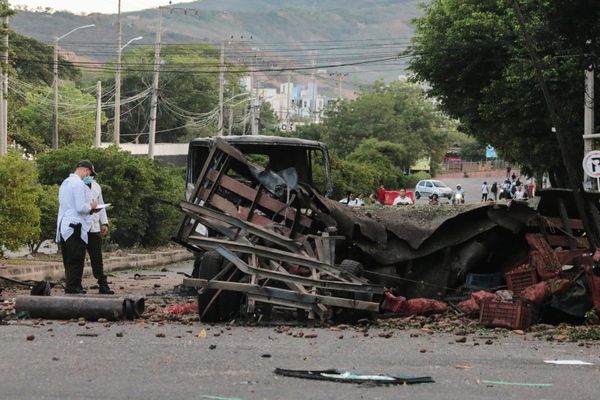
There have been no reported injuries but residents are reporting structural damage and trees down.
Not seeing a lot of structural damage #CycloneKirrily pic.twitter.com/unR1rXUPRZ
— The Wellerman Comes (@GregPankhurst) January 25, 2024
Updated
Disaster management meeting
Queensland’s premier, Steven Miles, will chair a Queensland disaster management committee meeting at 9am local time discussing the impact of ex-Tropical Cyclone Kirrily and provide an update to the media afterwards.
We will endeavour to bring it you live here.
Updated
Some Townsville locals approached Tropical Cyclone Kirrily with a note of humour last night. Reader: stocking up on beers is not advised by this outlet.
Townsville is ready for #CycloneKirrily. pic.twitter.com/JJk7B30ZQo
— Siobhan Heanue (@siobhanheanue) January 25, 2024
Highway flooding
Here is footage of the Bruce Highway, the main route that tracks from Brisbane through Townsville, overnight.
Townsville QLD - North: Bruce Hwy flooding on webcam via https://t.co/BcUj8o3FYb
— Ben John (@benjohn65) January 25, 2024
Severe Tropical #CycloneKirrilyhttps://t.co/l2iVLcyWcW pic.twitter.com/4nX2DmOju5
You can take a look at current hazards, including road damage, on the Queensland Traffic website. Flash flooding is occurring at a number of areas on the coastline, with reported road closures and long delays expected.
Updated
Nearly 60,000 households and businesses without power
Power outages have increased from 55,102 earlier this morning to 59,952 across regional Queensland, according to Ergon energy.
That includes the 45,988 in the Townsville city council area, 8,784 outages in the Burdekin shire, 1,752 in Hinchinbrook shire and 1,486 in Cloncurry shire .
Last night Ergon energy posted on social media it would share updates on outages and restoration when crews were able to safely start moving.
Lotsa debris #CycloneKirrily pic.twitter.com/BYqo7XPJXu
— The Wellerman Comes (@GregPankhurst) January 25, 2024
Residents are reporting trees down – some of them very sizeable.
Few trees down #CycloneKirrily pic.twitter.com/lczTEq3LT7
— The Wellerman Comes (@GregPankhurst) January 25, 2024
Updated
No injuries reported
Federal minister for emergency management Murray Watt says there have been no reported fatalities – or even injuries – as a result of Tropical Cyclone Kirrily.
Kirrily made landfall as a category-two cyclone north of Townsville about 10pm last night, just after being downgraded from a “serious” category-three storm.
It was downgraded to a tropical low early this morning.
But Watt said the danger isn’t over yet, with heavy rain expected across the region.
Ex-TC Kirrily now moving west across Nth Qld, after making landfall just north of Townsville last night. Many people without power, but no reported fatalities or injuries. Heavy rain is expected, with possible flooding on the coast and inland. Pls stay across @BOM_Qld warnings.
— Senator Murray Watt (@MurrayWatt) January 25, 2024
Updated
Heavy rainfall to hit parts of Queensland
To recap, focus is now turning on heavy rainfall to hit parts of Queensland after the crossing of Tropical Cyclone Kirrily.
The cyclone has been downgraded to a tropical low and is continuing to weaken as it turns inland. It’s now north of Charters Towers.
There are seven flood warnings active across the state, including a moderate flood warning for the Paroo River and minor warnings for the Herbert River, Bulloo River and Cooper Creek.
A severe weather warning is active for the northern goldfields and Upper Flinders regions, and for parts of Gulf Country, the north tropical coast and tablelands, Herbert and Lower Burdekin, north-west and central west districts.
The Bureau of Meteorology has warned that the after affects of the cyclone are likely to produce heavy rainfall, with possible damaging winds over parts of the state’s north:
Locally intense rainfall which may lead to dangerous and life threatening flooding is also possible on the northern flank of the tropical low.
Isolated 6-hourly totals between 150 to 180 mm are possible, with 24-hourly totals of around 250 mm also possible. Damaging winds with peak gusts of around 90 km/h are possible within the warning area.
Updated
Pat Dodson ‘a real hero’, Katy Gallagher says
Today is also the final day of Pat Dodson’s career in the Senate.
The WA senator, known as the father of reconciliation, departed parliamentary life with a “sense of sorrow” after the failure of the voice to parliament referendum.
Katy Gallagher says she remembered Dodson at 4am today.
I was thinking was it the day before Australia Day or Australia Day that he was leaving? I will send him a message today to tell him how much we will miss him. The father of reconciliation, a giant in public policy and community service and we will miss him as a work colleague point of view, but we know he has a lot more to contribute.
He is a real hero. I hope he is fishing off the coast of WA, which is one of his favourite places to be.
Updated
‘It is 26 January’
Katy Gallagher is asked whether there is an “air of inevitability” on the date of Australia Day being moved from 26 January, considered a day of mourning by many First Australians.
She replies:
I accept people have different views about it. Australia Day is on 26 January. I am looking forward to a full day of commitments here in the ACT. It is a day where people celebrate but they also remember our shared history and from the government’s point of view, there are no plans to change Australia Day. It is 26 January.
Updated
‘There is no other proposal’
As to getting the legislation through the Senate, which will require the support of the two crossbenchers and the Greens, Katy Gallagher says the easiest way is “for the opposition to back these in”:
If they decide to oppose that and we will leave them to explain that, then we will work with other senators to get it through. This is the proposal we will be taking. There is no other proposal. The one we are taking is the one that the prime minister outlined. When the Senate has to vote on this, the Senate will support billions more dollars going into peoples’ pockets from 1 July because every senator knows just how tough people are doing it, particularly in middle Australia.
Updated
Making a difference to ‘millions more Australians’
The finance minister, Katy Gallagher, has appeared on ABC News Breakfast.
Returning to the broken election promise line, she said:
We have taken this decision because it is the right decision but it is also about putting people first.
Your audience knows there has been many stories around cost-of-living pressure, particularly over the last year, and this plan gets bigger tax cuts into more Australians’ pockets from 1st July and that is what has resulted in us taking this decision.
We accept there is going to be politics around that and we don’t take this decision lightly. At the end of the day, in government, you have got a couple of choices on this regard, we could have done nothing and kept on that track or we could have changed our position and made a difference to millions more Australians, including women and young people who are going to benefit from these changes.
Updated
‘The Greens’ pressure works,’ Adam Bandt says on tax cuts
Back to the stage-three tax cuts, the Greens leader Adam Bandt is appearing on ABC RN, vowing to push Labor harder to support people on low and middle incomes:
Asked whether the party would realistically block reforms which deliver to a larger tax bracket, Bandt says:
People are entitled to expect more from Labor than just being slightly less crap than Scott Morrison.
We had a fundamentally unfair package from Labor, we now have a chance to change that and really tackle inequality and the cost of living and the housing crisis in this country.
Pushed again whether the Greens would pass the legislation if it didn’t secure further reforms, Bandt says “pressure works and the Greens’ pressure works”:
What is Labor’s case for delivering a $4,500 tax cut to the top end while asking everyone else to be satisfied with $15 a week? We dragged Labor kicking and screaming to realise it’s unfair … it’s the Greens job to push for more.
Updated
‘We mourn for the people of Palestine’
The Aboriginal Legal Service, representing NSW and the ACT, has issued a statement using 26 January to “speak up for the people of Palestine” and stand with its people:
In our shared mourning, we uphold the tradition of Aboriginal-Palestinian solidarity in Australia. The ALS is the nation’s oldest free legal service and we have always maintained that everyone deserves to be safe and treated fairly under the law, no matter who you are or where you come from … yet, right now, not all people are safe nor equal under the law.
The legal service says tens of thousands of Palestinians have been killed since the conflict began, with countless more missing:
We mourn for the people of Palestine, from the river to the sea. We mourn for the Israelis who have been killed or are still missing from their families. We mourn the generations of Palestinian children growing up behind concrete walls, barbed wire, and checkpoints … we applaud the thousands of Jewish people in and outside of Israel standing for justice and peace.
It calls on the federal government to step up its public efforts for an immediate and permanent ceasefire, and to work with the international community to “prevent further genocide … including the sustained destruction of Palestinian cultural heritage”:
We call on the Australian government to fast-track official recognition of the state of Palestine.
It should be noted that “from the river to the sea” is a controversial slogan with multiple interpretations, some of them offensive. For more on that, in the UK context, you can read this explainer:
Updated
‘It’s not a day to celebrate’
Many Australians have a complex relationship with 26 January, which is also called Survival Day or Invasion Day.
Our reporter, Rafqa Touma, has collated a guide to protest marches and events you can take a look at, and we also have some wonderful opinion pieces from Paul Daley and Dorinda Cox.
Invasion. Survival. Mourning.
— First Peoples' Assembly of Victoria (@firstpeoplesvic) January 25, 2024
These are just a few of the things mob feel on January 26. It's not a day to celebrate.
To our allies, thanks for standing with us. To mob, stay strong, stay deadly and stay safe ✊🏾
Always was, always will be, Aboriginal land. pic.twitter.com/rFaB5fY4RJ
Updated
First Nations ‘uplift our nation’
Continuing with the prime minister’s address, he turns to our First Nations people, and the “unique privilege” we have to be home to the oldest continued culture on Earth:
Aboriginal and Torres Strait Islander people have loved and cared for this country for over 65,000 years and they continue to uplift our nation.
Over generations, people from every part of the world, from all faiths and backgrounds and traditions, have enriched and enlarged our society and our democracy – adding to our national spirit of aspiration and endeavour … to create a better life and greater opportunity for our children and our grandchildren.
Anthony Albanese says “that story continues today”, pointing to citizenships to be declared, and gives a nod to armed forces and their sacrifice:
Everything we have we’ve built together. We cherish that, we celebrate it, and best of all, each of us has the chance to add to it. Working together, we can make this an even better, stronger, and fairer country. Happy Australia Day.
Unsurprisingly, no talk of changing the date – it was all about unity, multiculturalism and values.
Updated
‘All of us can be proud of how Australia’s diversity strengthens our unity,’ PM says
The prime minister has posted his Australia Day message, set against a nice little backdrop of wattle:
My fellow Australians, today as many of us are celebrating Australia Day, our first thoughts are with those communities battling natural disasters.
Seeing people work together to save lives and rebuild homes and businesses is a powerful reminder that the worst of times reveal the best of the Australian character.
Happy Australia Day. pic.twitter.com/Z9ZqAv08n2
— Anthony Albanese (@AlboMP) January 25, 2024
The PM says Australia’s values of “compassion and respect, courage and kindness” are at the heart of our national identity.
These values and how they shape our nation are what we pay tribute to on Australia Day, indeed when we look at everything happening around the world today, all of us can be proud of how Australia’s diversity strengthens our unity.
Updated
Sydney temperatures could reach as high as 40C
Turning to New South Wales, it’s going to be a sweltering one in Sydney today, with temperatures possibly hitting 40 degrees.
Angus Hines said for most places today will be the last warm day of this current run:
There is a cool gusty southerly change which has already worked its way into southern New South Wales … and that will be wiggling its way northwards throughout the course of the day today, potentially reaching Sydney around 2pm and that will turn a really warm day much, much cooler.
We might drop down from 28, 29 to 25 … but southern parts of Queensland won’t get there today, maybe overnight tonight for a slightly cooler weekend.
Updated
Cyclone wind gusts peaked at 140km/h
Angus Hines at the Bureau of Meteorology told ABC News Breakfast the strongest wind gusts felt by Tropical Cyclone Kirrily peaked at 140km/h at offshore islands and reefs.
On the mainland, gusts peaked at 110 km/h, and in the 90s at Townsville itself:
That’s been enough to cause extensive damage with powerlines add debris down … as we move into today and the next couple of days, the focus shifts away from wind a little bit and towards rainfall and potential flooding as we watch the remnants of the ex-tropical cyclone make its way into inland interior Queensland, bringing a widespread swathe of rain.
We’ve already seen rivers pushing up across Queensland and the river levels still going up, so the possibility of moderate or major flooding does remain, particularly near the path of this ex-tropical cyclone.
Hinds said moving to the weekend, the impacts would continue in western Queensland and the north-west district around Mount Isa.
Updated
‘Remarkably’ few requests for assistance, QFES says
Acting QFES commissioner Stephen Smith joined ABC News Breakfast from Brisbane this morning to discuss the impacts of the cyclone, which has since been downgraded to a tropical low.
Smith said swift water crews hadn’t had to performed any rescues, while there were just 170 requests for assistance – a “remarkably low” figure given the circumstances:
The [requests] were for storm damage, trees down, flooding, those sorts of things you would absolutely expect from an event like this … but the numbers are much lower and that’s a credit to the community.
With approximately 55,000 north Queensland homes reported to be without power, Smith said only just getting into daylight hours, crews would work to restore as many homes as they could “through the day and coming days”:
With trees down, debris down, it takes time. Crews work really hard and we’ve seen that in the last period of time from Tropical Cyclone Jasper very recently – crews working incredibly hard to do that as quickly as they possibly can.
Updated
Townsville residents told it is safe to venture outside
Residents in Townsville have been advised it is safe to leave their homes after the passing of Tropical Cyclone Kirrily.
EMERGENCY ALERT for TOWNSVILLE as at 6am Friday, 26 Jan: https://t.co/krCoCPpxJM
— Qld Fire & Emergency (@QldFES) January 25, 2024
Queensland Fire and Emergency Services posted 6am local time that the weather event had passed and residents could leave their place of shelter:
Avoid unnecessary travel and be aware of damage caused by the cyclone, including fallen powerlines. Listen to local radio.
Updated
Emma McKeon named Young Australian of the Year
Many Australians have been honoured in Australia Day awards for their outstanding achievements.
The Young Australian of the Year award this year is swimmer Emma McKeon – the nation’s most decorated Olympian.
She appeared on ABC Breakfast this morning, expressing her shock at receiving the award. McKeon said the award was equally as special as her many gold medals and achievements in the pool:
It hasn’t really sunk in, but I just hearing the other speeches of the other award winners, you really start to feel how special it is … it’s inspiring and I loved being in the room with all these people.
She said she would use the platform to attempt to “inspire young Australians around the country, just to go after their dreams, no matter whether it’s in sport or anything else”:
I think there are different times throughout life that you can get discouraged and you kind of stop believing in yourself … but I want to encourage people to keep pushing on. I was once in that position of a young kid looking up to incredible athletes doing amazing things and that kind of ignited this dream inside me.
When I decided to keep swimming after Tokyo, I knew that I wasn’t ready to stop yet and I felt like I had more to give so it’s exciting for me now that it’s Olympic year again … it’s definitely in sight now with only six months to go.
Read more about the winners here:
Updated
Sally McManus talks tax cuts
In other news, secretary of the Australian Council of Trade Unions Sally McManus is appearing now on ABC RN to discuss the Labor government’s reformed stage-three tax cuts.
Asked about opposition leader Peter Dutton’s comments that the PM should go to an election and take the proposal to voters, McManus replied:
I think Peter Dutton tried to throw everything at it yesterday and really jumped the shark … he was saying all sorts of things, that this was about a byelection … and missing the main point.
The government has acted to address these cost-of-living pressures and he didn’t want to talk about that. And in fact I think he looked a bit nervous.
Turning to the much-touted line in the media of broken promises, McManus said it didn’t make sense for the federal government to “blindly walk us forward because they promised something ages ago”:
They are delivering the tax cuts, they’ve decided to reconfigure those tax cuts … it’s like someone said to you, ‘I’m going to give you $50 and then they say I’ve decided I can give you $100’ – for most Australians, that’s exactly what happened.
Updated
‘The story isn’t over’
Miriam Bradbury, senior meteorologist at the Bureau of Meteorology, just appeared on ABC RN.
She noted the cyclone’s impact “wasn’t so much a rain event as a wind event”, with the highest gusts felt in offshore reefs:
Residents will be waking up to quite a bit of debris on the road. From here the important thing to note is … the impacts expected in the coming days are covered by a severe weather warning … reflecting the path we expect that ex-tropical cyclone to take.
The worst is over in terms of the absolute strongest winds that are expected but the story isn’t over.
Surprised at just how little rain we're seeing with this storm. Have experienced some fairly strong gusts in the past few minutes however along with some explosive power flashes quite close to our location 🌀#CycloneKirrily pic.twitter.com/v0pyECNNRB
— Jason H (AU) 🇦🇺 (@OreboundImages) January 25, 2024
The highest rainfall was at Peluma north of Townsville, which has lashed with 176mm to 6.30am. Townsville received relatively modest rainfall, at 30mm.
Inland from Mackay, Clark Range was hit with 145mm of rainfall in 24 hours. A number of flood watches are current.
More yachts coming to grief down on the Strand as the back side of #CycloneKirrily continues to pack a punch here in #Townsville 🌀
— Jason H (AU) 🇦🇺 (@OreboundImages) January 25, 2024
☆ Not for media use ☆ pic.twitter.com/UPbZWQ3Vsx
Updated
Flooding risks
With Tropical Cyclone Kirrily downgraded to a tropical low, the focus now turns to heavy rainfall expected to hit parts of Queensland today, bringing the risk of flash and riverine flooding.
⚠️ A Severe Weather Warning has been re-issued for inland North Queensland. Ex-Tropical Cyclone Kirrily is expected to produce heavy to locally intense rainfall and possible damaging winds over the warning area today. Details at https://t.co/m0qLcbkBhG pic.twitter.com/aZugRvQPDd
— Bureau of Meteorology, Queensland (@BOM_Qld) January 25, 2024
The storm surge reached 1.1 metres above usual tide levels at Cape Ferguson, and 0.9 metres at Townsville.
No innundation with #CycloneKirrily crossing before the highest tide of the day. Storm surge reached 1.1 metres above the usual astronomical tide at Cape Ferguson and 0.9 metres at Townsville. Data from: https://t.co/6SVdY6fjEy pic.twitter.com/0G4T4sMx8Q
— Bureau of Meteorology, Queensland (@BOM_Qld) January 25, 2024
Updated
Here is some footage of Townsville as Tropical Cyclone Kirrily crossed the coast.
Tropical cyclone Kirrily crossing the coast. Was wild and windy in Townsville in quick bursts. Calmer now. @10NewsFirstQLD pic.twitter.com/JiWWmDAVV5
— Georgina Hill (@GeorgiHill10) January 25, 2024
Residents reported fallen trees blocking roadways amid strong wind gusts.
Seeing plenty of trees down around the place just to the north of #Townsville. Some stronger wind gusts in the past few minutes with squalls, though nothing too over the top just yet 🌀#CycloneKirrily pic.twitter.com/XecrDfjWC1
— Jason H (AU) 🇦🇺 (@OreboundImages) January 25, 2024
#Townsville feeling the impacts of severe Tropical Cyclone #Kirrily.
— Justin Noonan (@NoonanJustin) January 25, 2024
For licensing contact @SevereWeatherAU pic.twitter.com/iZddxw2HsK
Updated
Power outages
Some 55,102 people are without power in regional Queensland, according to the Ergon Energy network, including 41,138 in the Townsville council area.
Townsville Tropical Cyclone Kirrily takes out the power at Hermit Park.#tropicalcyclone #kirrily #CycloneKirrily #TownsVille #AustraliaDay26Jan #Australia pic.twitter.com/b73BUbgFBT
— Iyarkai (@iyarkai_earth) January 25, 2024
At 8.30pm, Ergon posted on social media:
We’re seeing outages due to winds whipping up debris, and the situation is worsening as Kirrily approaches the coast. The biggest impacts to our network so far are in and around Townsville and Burdekin, where nearly 36,000 customers are off supply.
We’re also recording outages from wind and debris across the Whitsunday, Hinchinbrook, Charters Towers shires, as well as general storms and other network faults affecting Cloncurry, and pockets in the Far North, Central Qld and the South West.
Our teams and their families in Kirrily’s path are bunkering down while this dangerous system roars in. The only priority tonight is safety – getting through this storm – then when it’s safe to start moving around tomorrow, we’ll begin damage assessments.
Updated
The moment of impact
This was Tropical Cyclone Kirrily is it made landfall yesterday evening just after 10pm.
Townsville in the bullseye as Severe Tropical Cyclone Kirrily makes landfall, currently crossing the coast as a category 3 system with wind gusts estimated to be reaching 165km/h near its core. pic.twitter.com/n6cLENuSFs
— Ben Domensino (@Ben_Domensino) January 25, 2024
The prime minister, Anthony Albanese, said the federal government was “working with the Queensland and local governments closely”, with ADF personnel on the ground alongside emergency services.
Cyclone Kirrily is becoming more intense as it makes landfall near Townsville. We are working with the Queensland and local governments closely.
— Anthony Albanese (@AlboMP) January 25, 2024
Our ADF personnel have already been assisting with preparation – and remain on standby to assist local emergency services. pic.twitter.com/L2nGSeHpYq
Updated
Warning to stay indoors
Queensland Fire and Emergency Services has warned residents in areas impacted by Tropical Cyclone Kirrily to avoid going outside until it is safe to leave the home:
You don’t want to be out and about while there are fallen trees, powerlines and displaced debris, especially when it is still dark and vision is limited.
As TC Kirrily moves through you should not be outside exploring or inspecting potential damage.
— Qld Fire & Emergency (@QldFES) January 25, 2024
Please stay indoors until you receive advice it is safe to head outside.
You don’t want to be out and about while there are fallen trees, powerlines and displaced debris,… pic.twitter.com/4bPgAn52hJ
While the cyclone has been downgraded, the Bureau of Meteorology warned it was still bringing damaging wind gusts and heavy rainfall.
Tropical Cyclone Kirrily crossed the Queensland coast as a category two system at 10 pm AEST, between Townsville and Ingham, and is now moving over land #CycloneKirrily
— Bureau of Meteorology, Australia (@BOM_au) January 25, 2024
Latest: https://t.co/jlOoTZL1iF or the BOM Weather app. pic.twitter.com/PRqWxJ08iA
Updated
Welcome
Good morning and welcome to our live coverage of the Tropical Cyclone Kirrily, which hit on Townsville last night as a category-three storm.
The cyclone crossed the Queensland coast at 10pm.
It downgraded to a category-two storm and then category one as it made its way inland, the Queensland Bureau of Meteorology said, weakening further to a tropical low by this morning. At midnight the bureau said:
Winds near gale force in Townsville … with gusts to 82km/h. Conditions should ease further in coming hours.
By 4am AEST, it had been downgraded again to a tropical low, with sustained winds near the centre of 55km/h and wind gusts of 85km/h.
The bureau said it could still bring strong winds and heavy rain as it moves inland north-west of Charters Towers. Meteorologist Miriam Bradbury said:
It will carry a lot of that moisture with it, gradually pushing it through central and then more western parts of Queensland.
Read our full story here: