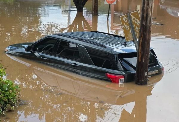
More than 4.7 sq km of inner-Melbourne and swathes of Port Phillip Bay could face the threat of rising sea levels and storm tides fuelled by climate change in the coming decades, complex modelling released by the Victorian government shows.
The Port Phillip Bay coastal hazard assessment, released on Thursday, found that Docklands and Southbank in the Melbourne city council area could face inundation in the scenario of a 1.1-metre sea level rise, during a one-in-100-chance storm-tide event.
The analysis, first reported by the Age, found that a quarter of the Port Phillip council area – which includes St Kilda, Albert Park and South Melbourne – could face inundation under the same scenario.
Risks of inundation increased further during extreme rainfall events and under a scenario in which sea levels rise by 1.4 metres by 2100.

In Geelong, 47 sq km could be at risk of inundation – 4% of the total council area – as the result of a 1.4-metre sea level rise.
The study – commissioned by the state government – outlines the risks that coastal communities on Port Phillip Bay face. It includes modelling, analysis and maps outlining areas at risk of coastal hazard in bayside communities, with 1.3 million Victorians calling coastal areas home.
But Victoria’s environment minister, Steve Dimopoulos, on Thursday said it was important to not be “alarmist” about the report.
“This is a report for the next 80 years, not a report for the next five minutes,” he said.
“I wouldn’t be asking any community to be up in arms and concerned other than just to be informed and work with land managers and us to take mitigation efforts.”
Dimopoulos said the government had already funded councils around the bay to undertake their own mitigation strategies. He pointed to the government’s $140bn investment in coastal mitigation strategies such as sea walls since 2014.
The hazard assessment investigated the impacts of sea level rise, inundation, erosion and rising groundwater levels for communities around the bay.

The study found the flood-prone areas of Port Phillip Bay were Point Lonsdale, Queenscliff, Swan Bay and Portarlington to the south-west, Werribee and Altona to the north-west, Southbank and Port Melbourne to Elwood in the north and Mordialloc, Patterson Lakes and Martha Cove in the east and south-east.
The report will spark a debate over potential planning changes and inundation overlay in Victoria. Earlier this week, the premier, Jacinta Allan, said climate change-driven flooding and extreme weather events meant the state would need to consider the best locations for new housing.
“What used to be a one-in-100-year event for communities like Rochester, they’ve now had three big flooding events in 10, 11 years,” she told the ABC.
The reports were prepared independently of government by agencies, including the CSIRO.
The CSIRO report found the major hazard faced by coastal communities across the world was sea level rises.
It said rising sea levels would probably reduce the effectiveness of protective infrastructure such as sea walls and marinas. It found a higher sea-level rise would be caused by stronger tides, bigger waves and changes in the level of groundwater.