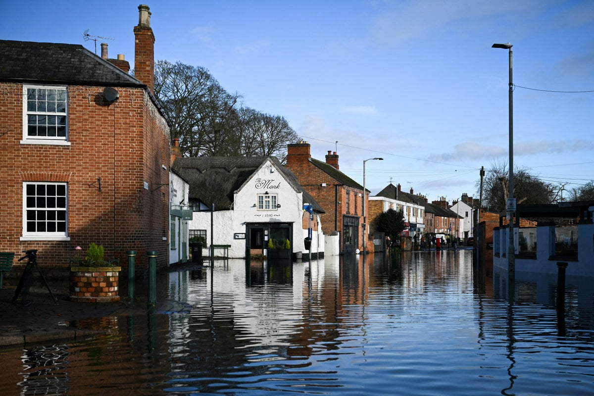
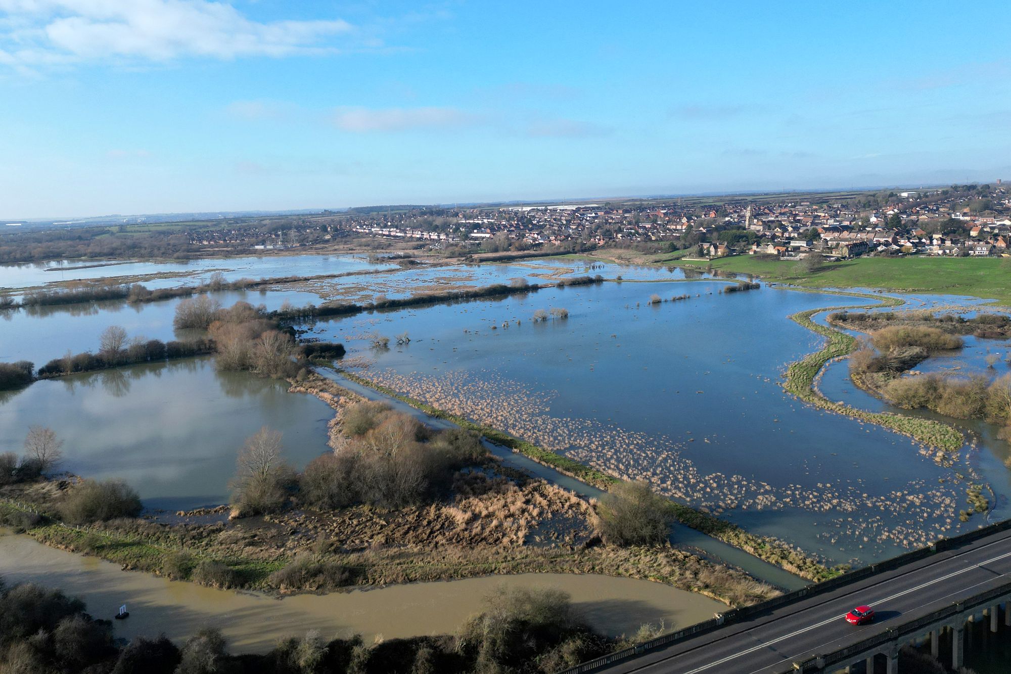
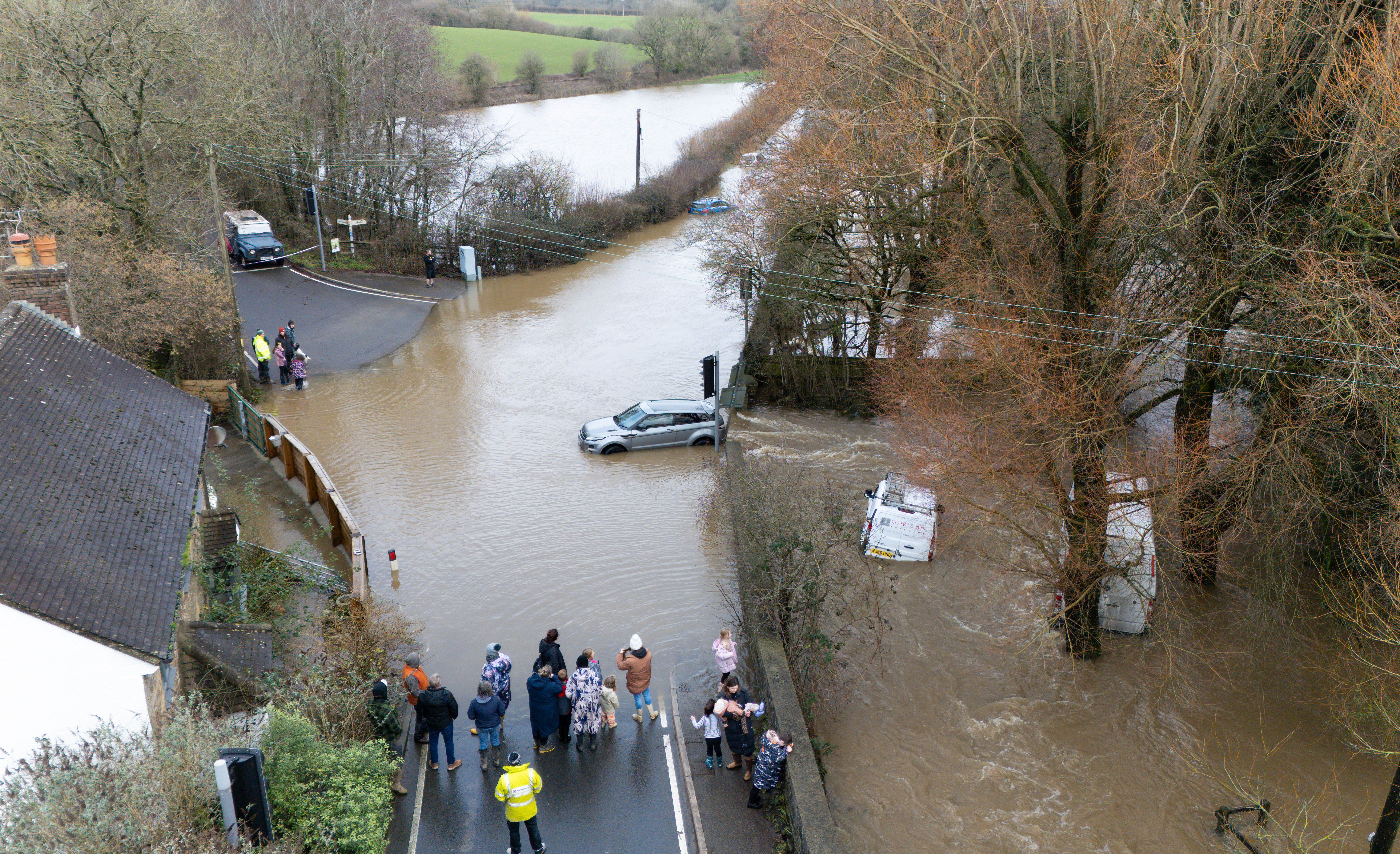
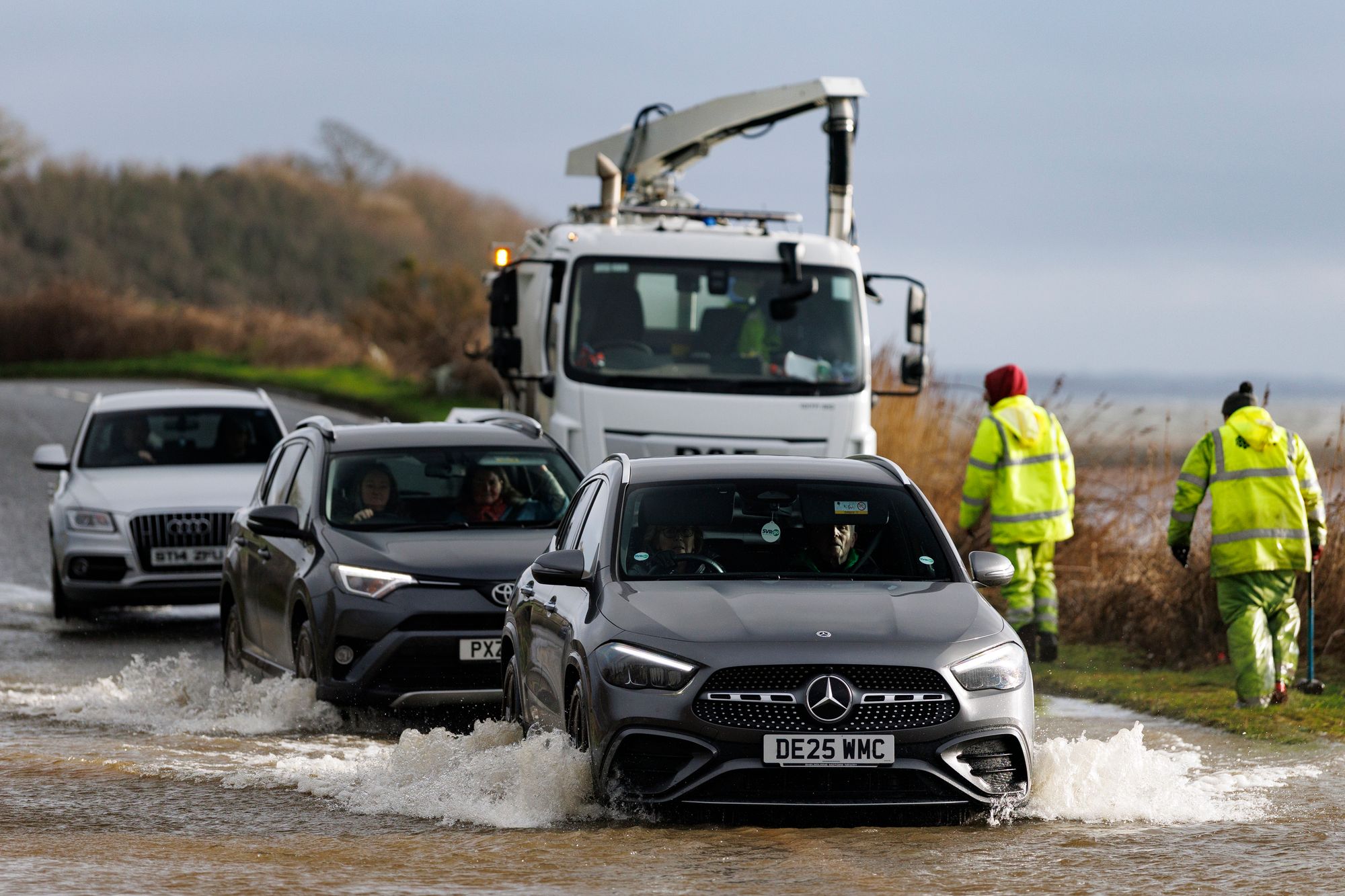
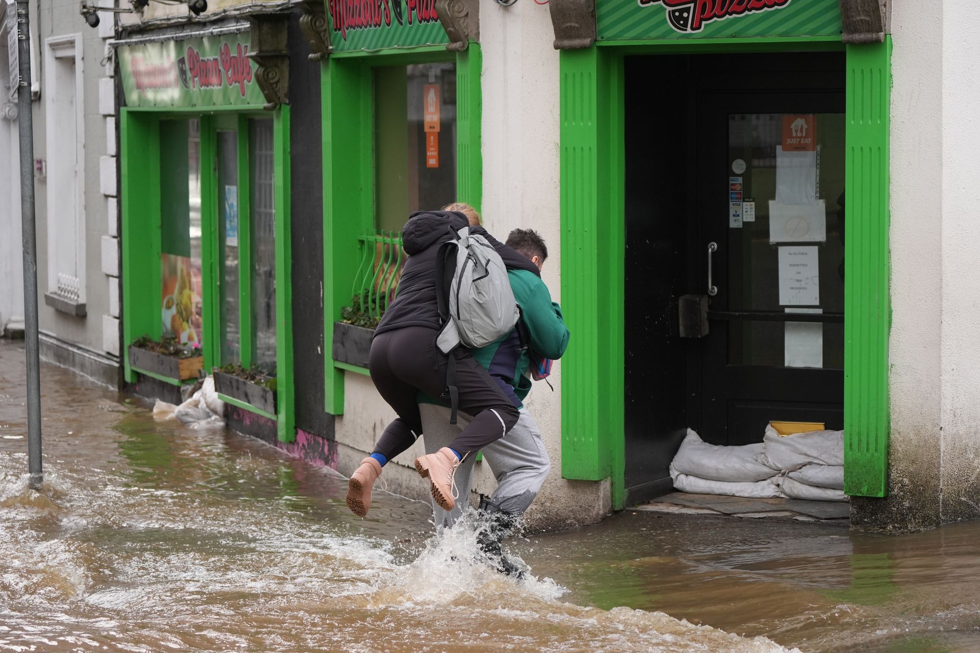
Further flooding is expected in the wake of Storm Chandra on Thursday and Friday, as fears grow that heavy rainfall could bring the worst flooding seen in more than a decade.
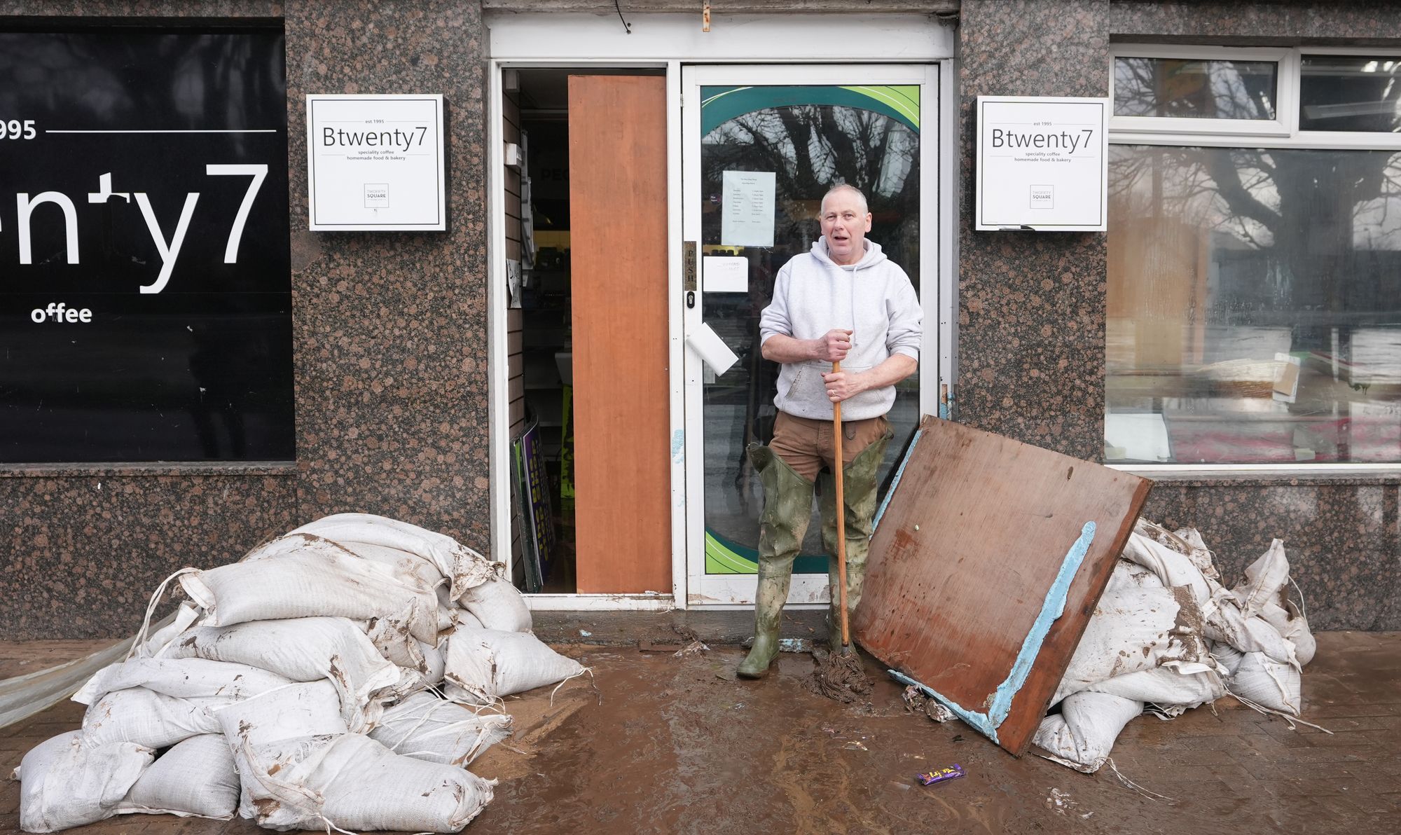
Already, more than 60 properties across England have been flooded following the storm earlier this week, while a major incident was declared on Somerset on Tuesday.
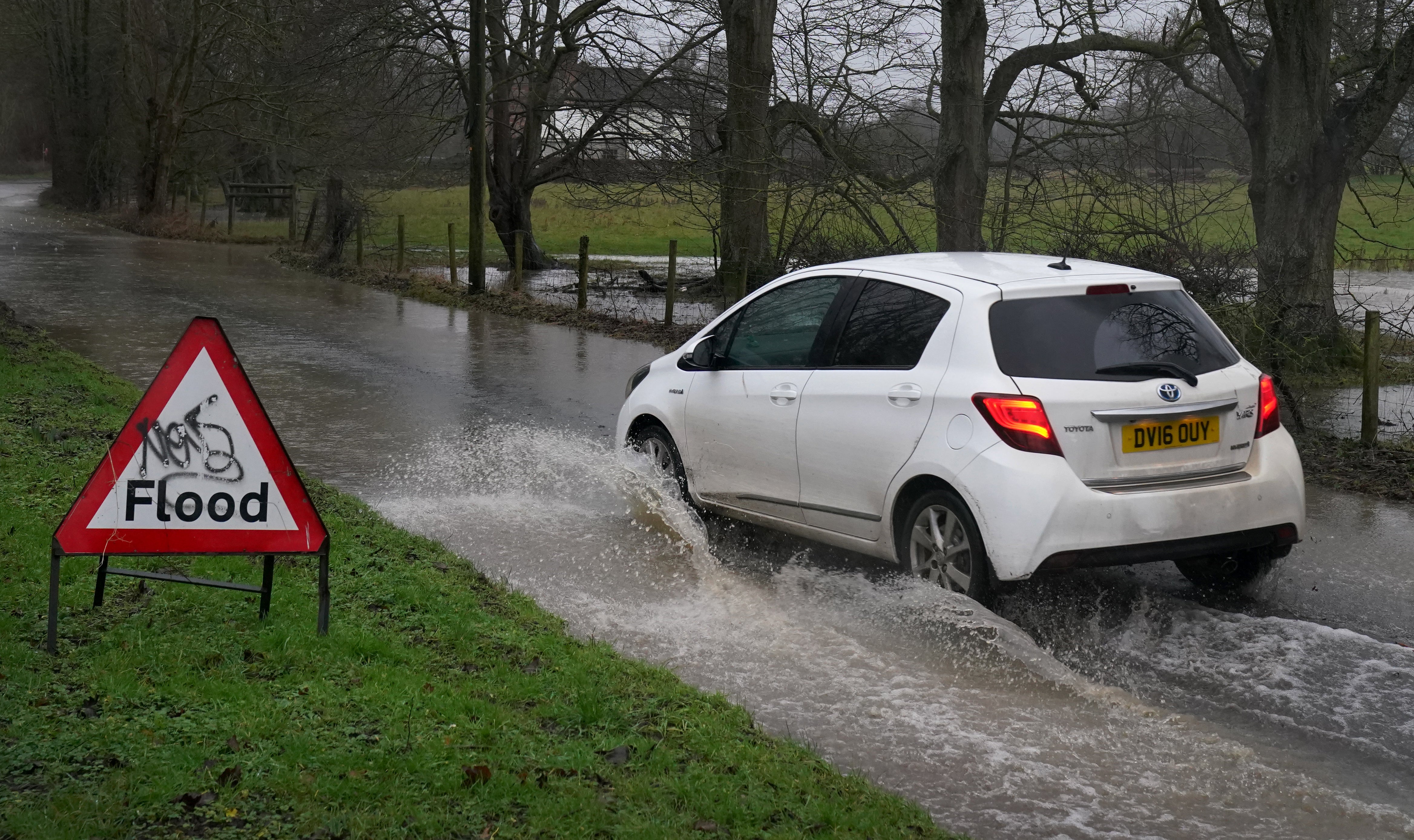
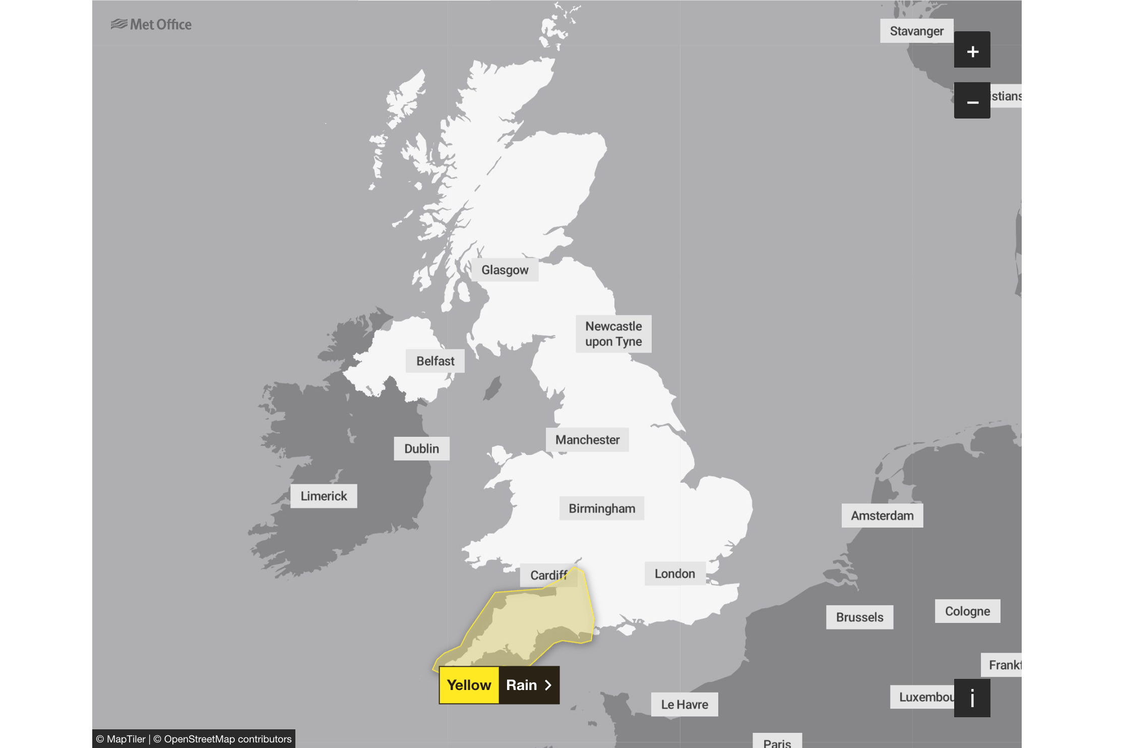
On Thursday, with dozens of flood warnings still in place, the Met Office issued a warning for rain in the south west of England from noon until Friday. Rain will be falling on already saturated ground, leading to concerns of further flooding.
Among those likely to be impacted are Lesley and John Parker, a retired couple living on the Somerset Levels, who described the conditions as the scariest they had seen since severe flooding in 2014.
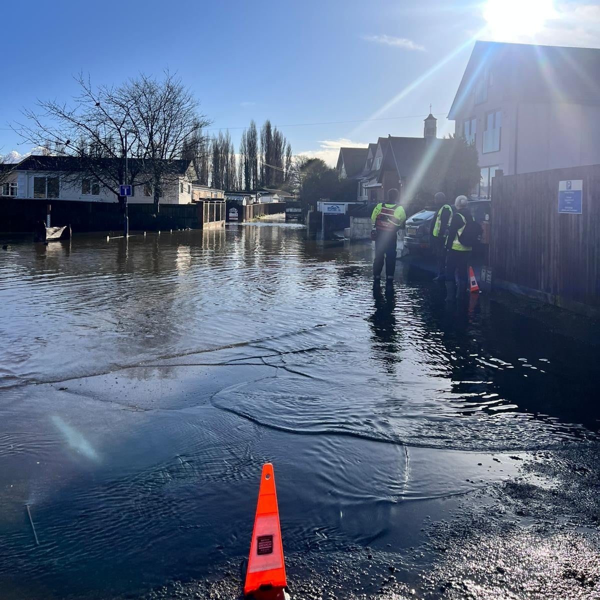
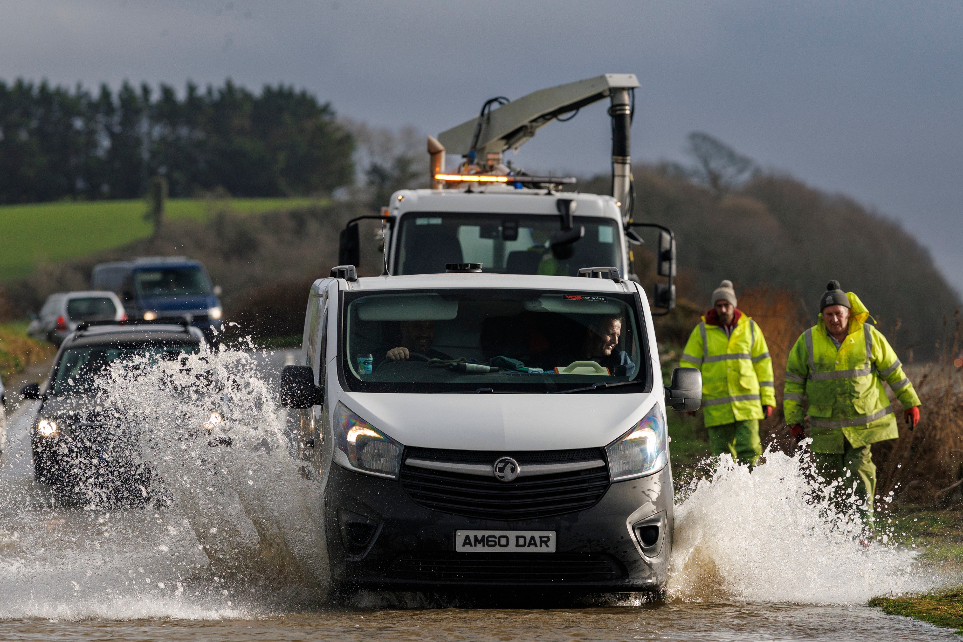
Roads in the West Country have also been blocked by flooding, while National Rail has warned of railway disruptions up until Friday.
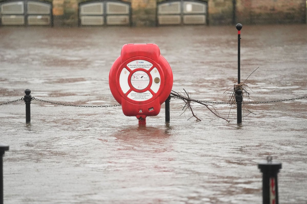
On Thursday morning, 76 flood warnings were in place where flooding is expected, most in the south west of England. A severe flood warning for “danger to life” was issued at Ilford Bridge Home Park in Dorset, where residents have been forced to evacuate.
Key Points
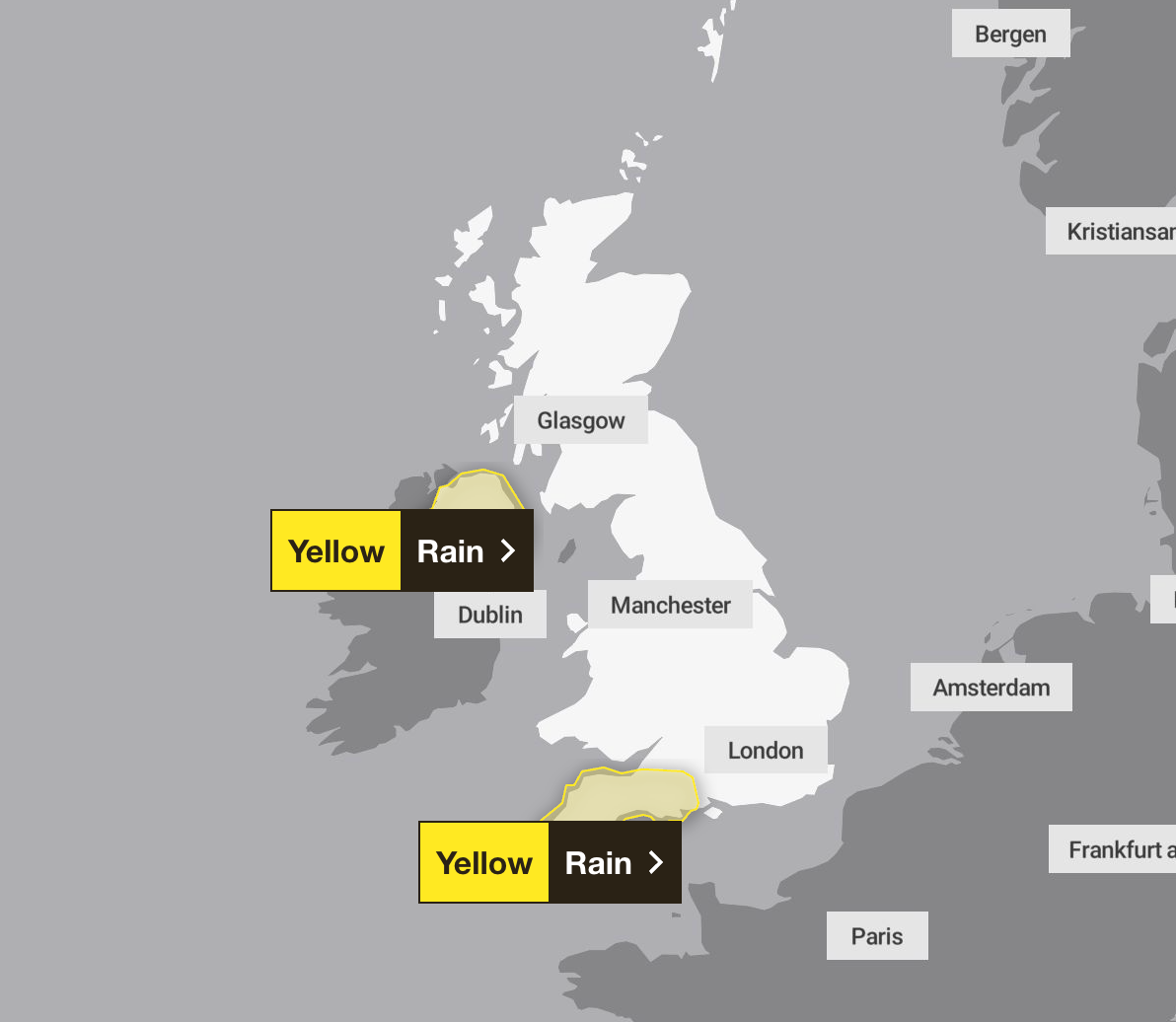
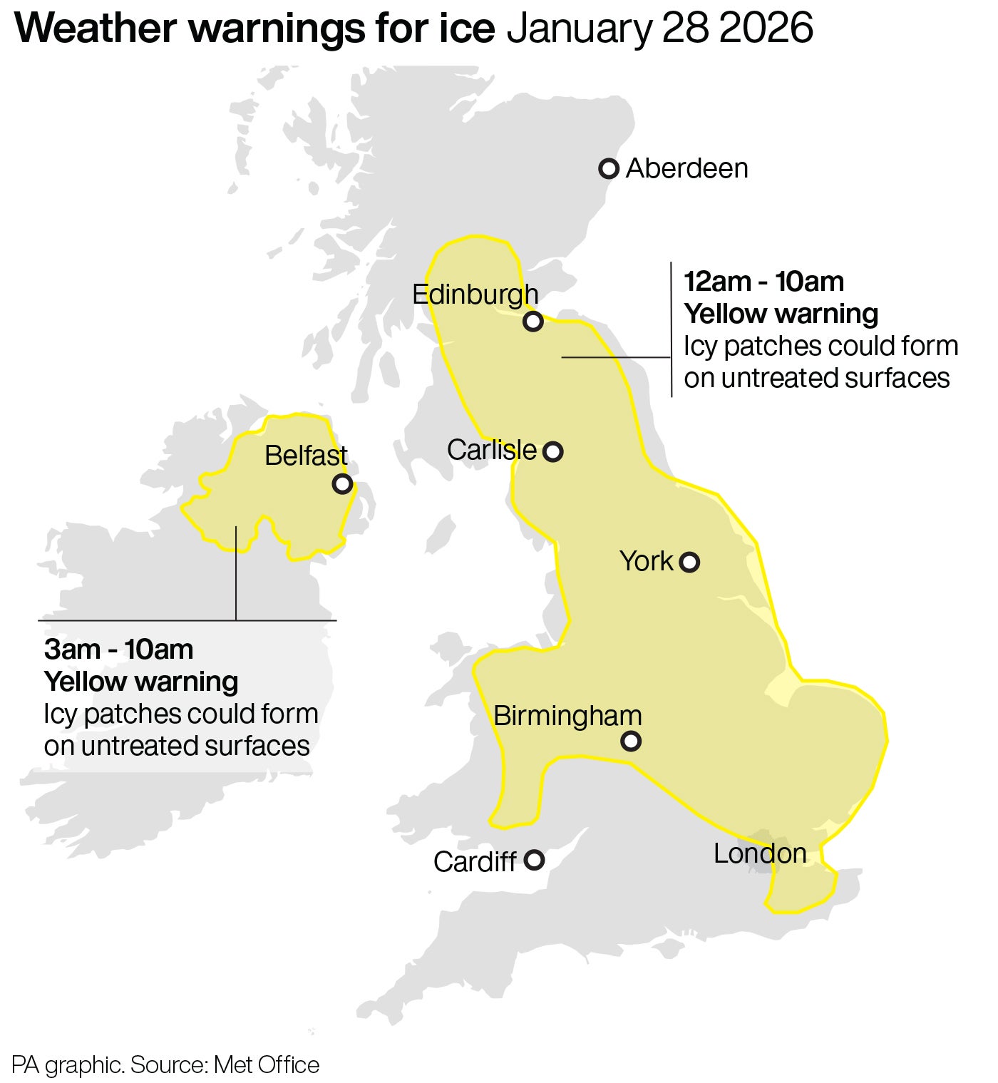
- A yellow weather warning issued for Thursday
- Two yellow weather warnings issued for Friday
- A 'major incident' of flooding declared in Somerset
- Severe disruption continues for trains in Devon and Somerset
- Schools remain closed in Devon and Somerset
Cloudy and foggy start to Thursday
05:00 , Shaheena UddinA cloudy start to Thursday with some fog, this slow to clear in places 🌫️
— Met Office (@metoffice) January 28, 2026
Feeling chilly with rain and hill snow continuing in NE Scotland ❄️
By midday, showers in the far southwest will be replaced by heavy rain, spreading eastwards later and adding to ongoing flooding ⚠️ pic.twitter.com/fHHb4NE98D
Explainer: What was driving Storm Chandra?
04:00 , Shaheena UddinStorm Chandra was formed from a deepening Atlantic low that tracked eastwards, bringing in a vigorous fetch of moist air from the southwest, according to the Met Office.
As it neared the UK the system escalated, carrying unusually strong easterly winds to parts of Northern Ireland, as well as strong gusty winds to the Isles of Scilly, Cornwall and southwestern Wales, which had already suffered damage from Storm Goretti.
Storm Chandra also pushed persistent and heavy rainfall into parts of Dorset, Somerset and Devon. An Amber warning for rain reflected the worries around the expected rainfall accumulations.
Drivers urged to carry floodkits due to heavy rain
03:00 , Shaheena UddinThe Met Office have warned drivers and residents in affected areas to prepare a floodkit, to help in the event that their home, business or car becomes damaged.
It is not safe to drive or walk or swim through floodwater, avoid it where possible and if you are affected by fast flowing or deep water call 999 and wait for help.
Preparing a floodkit should include:
- Insurance documents and list of contact numbers
- Torch & spare batteries
- First aid kit and any prescription medicines
- Warm waterproof clothes and blankets
- Bottled water and snacks
- Battery or wind-up radio
- Supplies for looking after your baby or pet
Highest UK rainfall totals from Storm Chandra
02:00 , Shaheena UddinA number of sites exceeded 60 mm, with the wettest locations seeing over 110 mm of rain:
- White Barrow, Devon – 115.1 mmThe highest total recorded during Storm Chandra, with sustained heavy rainfall through the morning of 27 January.
- Katesbridge, County Down – 114.8 mmA remarkably high total for Northern Ireland, highlighting the storm's broad footprint. Katesbridge also appears frequently in the hourly high‑rainfall records, showing consistent heavy bursts.
- Banagher, Caugh Hill, Londonderry – 83.2 mmAnother significant total in Northern Ireland, illustrating how Chandra’s associated rainfall band pivoted northwards.
- Dartmoor Training Centre, Devon – 75.7 mm,
- Brookfield Farm, Devon – 73 mm,
- Princetown Prison, Devon – 68.2 mm,
- Bellever, Dartmoor – 67.6 mm,
- Glen Ample, Stirlingshire – 66.6 mm.
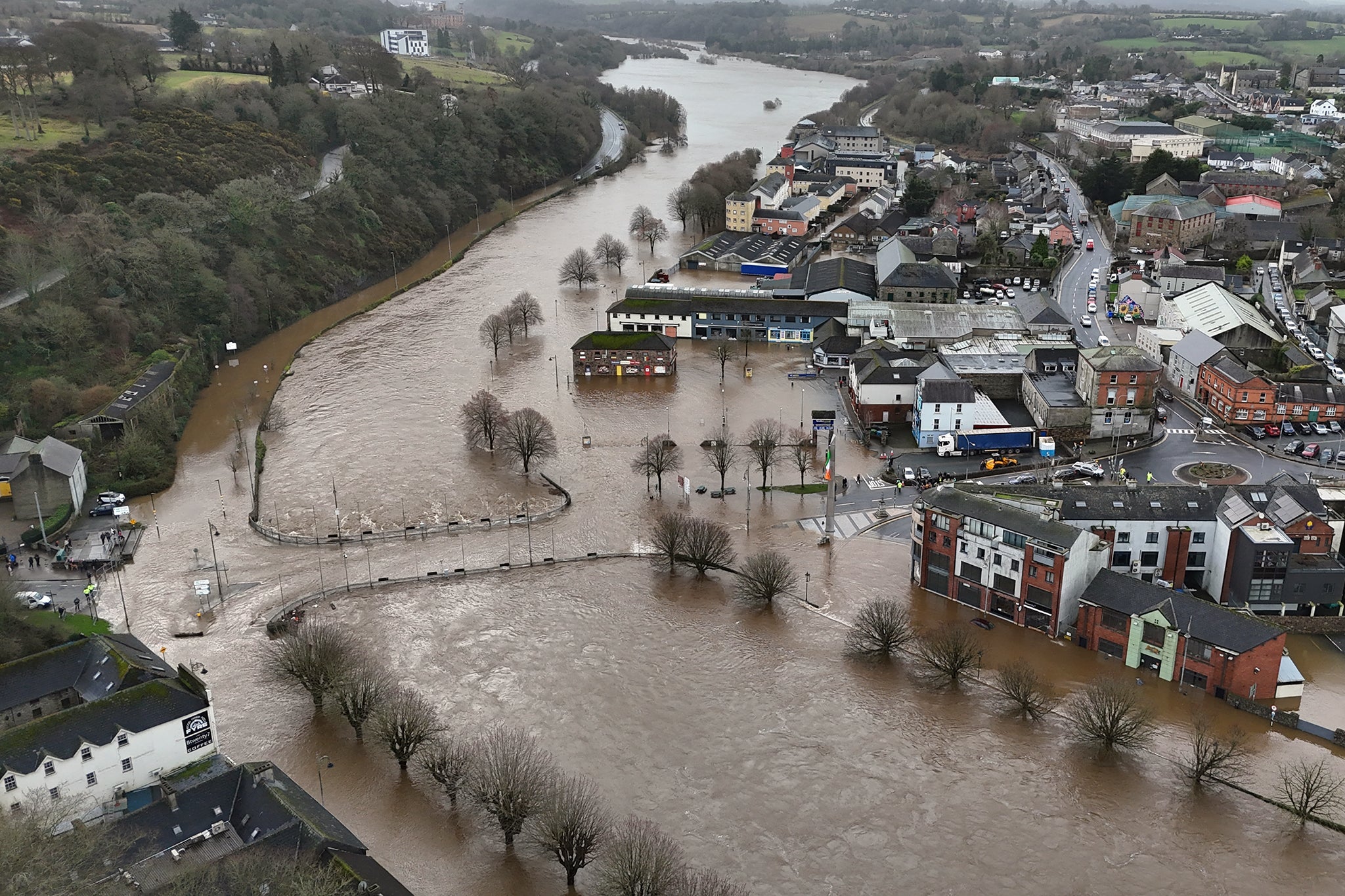
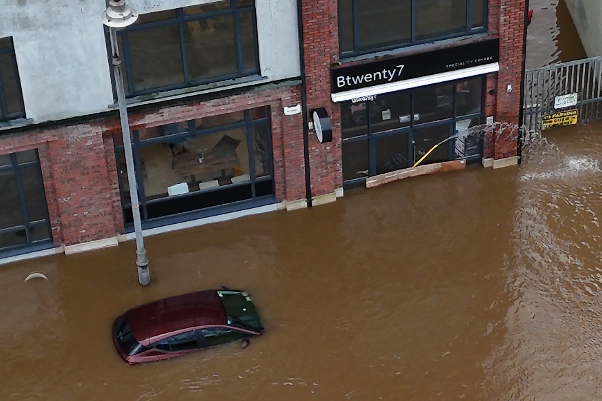
Storm Chandra map: Where heavy rain and flooding hit UK after ‘danger to life’ warning issued
01:00 , Shaheena UddinStorm Chandra has brought weather chaos this week with strong winds, heavy rain and snowbattering much of the UK, with the Met Office issuing further yellow warnings to Friday.
Read more:
Storm Chandra map: Where flooding hit today after ‘danger to life’ warning
Met Office shares tips for staying safe during flooding
00:00 , Shaheena UddinThe Met Office advises following these siz simple steps to protect your home or business:
- Check the flood advice in your area to know when and where flooding will happen
- Charge mobile phone devices
- Park your car outside the flood zone
- Prepare a flood kit to help you cope in the event of flooding to your home and business
- Store valuables up high, including electrical devices, important documents and furniture
- Turn off gas water and electricity supplies
Watch: 'Danger to life' warnings issued across UK and Ireland
Wednesday 28 January 2026 23:00 , Shaheena UddinFive tips for driving in fog
Wednesday 28 January 2026 22:00 , Shaheena UddinFog and low cloud is expected overnight, which could cause some difficult travel conditions.
RAC and National Highways have partnered with Met Office to share five tips for driving in fog:
1. Make sure you’re familiar with how to operate your front and rear fog lights
2. Do not use full beam lights, as the fog reflects the light back, reducing visibility even further
3. Follow the ‘two-second rule’ or even increase the gap to four seconds
4. Ensure the heater is set to windscreen de-misting and open all the vents
5. If visibility is very limited, wind down your windows at junction and crossroads
A married couple had to be rescued from their home by boat due to almost waist-high water
Wednesday 28 January 2026 21:45 , Shaheena UddinA married couple based in Antrim had to be rescued from their house by boat after flood water rose to almost waist-high.
David Leatherman and Jim Cunningham have since spoken about their frustrations in how the Department for Infrastructure (DFI) has handled the damage caused to their home by Storm Chandra.
Jim Cunningham told ITVX that the couple were "psychologically destroyed" by the damage to their house.
Speaking of the disaster Mr Leatherman said: "I came home and the water just was rising, and by 4PM, it was right up to our waists”, as reported by ITVX.
Mr Leatherman phoned the DFI and was told he would be put on a list. He then spotted two DFI staff walking up the street as the flood reached the telegraph pole there and asked them what they were planning to do about it.
The staff responded that they were trying to contact their boss but haven’t been able to get through to him and would come back in half and hour but they next showed up, according to Mr Leatherman.
Minister for Infrastructure (DfI) Liz Kimmins MLA met with the two men who were pulled to safety. She said to ITVX: "What happened yesterday in Riverside was "devastating" to all those who were impacted." She explained that the department received thousands of calls on Tuesday alone.
She added: “Our staff are working day and night, and we're trying to stretch our resources as far as possible, including deploying staff from different business areas within the department to try and support that.
"The pressure that we were feeling right across the north yesterday was really, really felt. Everyone was stretched trying to deal with what was coming at us from all different angles. That's not an excuse, I suppose it's just to say that's the reality of what we are dealing with on a very regular basis, and we have to make sure that we're targeting resources properly."
Met Office shares forecast map for Thursday
Wednesday 28 January 2026 21:30 , Shaheena UddinWill there be some 🌥️ or some more 🌧️ in the 4cast tomorrow? pic.twitter.com/OfB1kUSGlN
— Met Office (@metoffice) January 28, 2026
Further rain warnings issued for Ireland as Minister accuses forecasters of 'guarding' information
Wednesday 28 January 2026 21:00 , Shaheena UddinNew weather warnings for rain have been issued in Ireland, as communities hit by heavy flooding earlier in the week assess the damage.
Met Eireann has issued a Status Yellow rain warning for counties Dublin, Carlow, Kilkenny, Wexford, Wicklow, and Waterford which will be in effect all day Thursday.
A Yellow-level rain warning has also been issued by the Met Office for Northern Ireland, from midnight until 6pm on Friday.
Minister for Housing and Local Government James Browne said that information should not be “guarded” and he had asked Met Eireann to look at how they assess what level of weather warning is warranted.
He told South East Radio’s Morning Mix that Met Eireann needed to improve communications and said he was “really frustrated that some state agencies seem to think that it’s their duty to somehow withhold information”.
“We will be bringing Met Eireann in and say that, look, there needs to be an understanding here that information is not to be guarded, information is to be put out there and we need to do a much better job at communications,” he said.
“Also what we’ve asked Met Eireann to do is to look at how they bring these warnings – yellow, orange, red warnings – it’s based on a mathematical formula whereas in other countries they use the mathematical formula, but then they also make a judgment call and I there needs to be a greater use of that judgment call as well, I think in terms of being able to warn people of what is coming down the line.”
Labour’s climate spokesperson Ciaran Ahern responded to Mr Browne’s comments saying they were “extraordinary” and “ridiculous”.
“At a time when many areas across the country are flooding due to this Government’s failure to fund flooding defence systems that have been called for for years, this blatant attempt to distract and deflect must be called out,” he said.
“Storm Chandra must be a wake-up call for all of us but particularly those with a seat at the Cabinet table.”
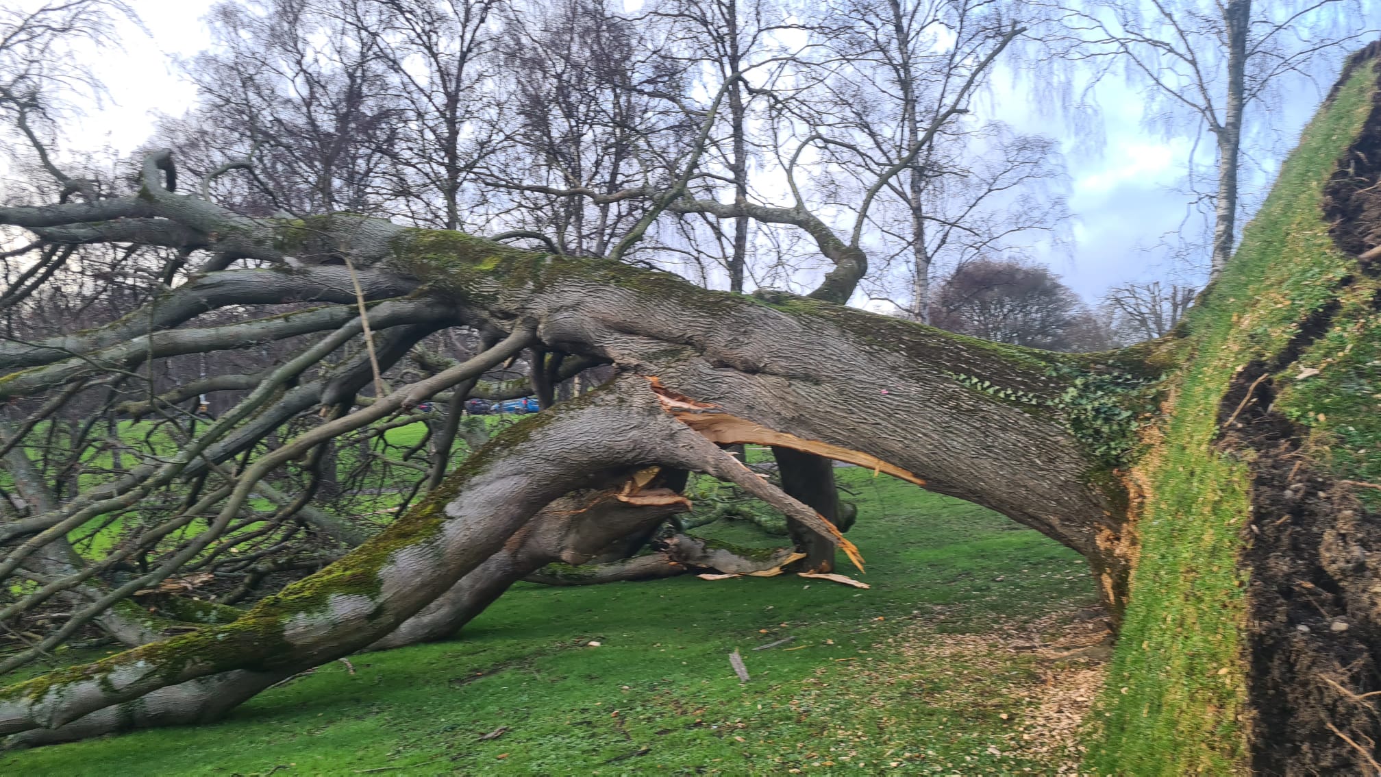
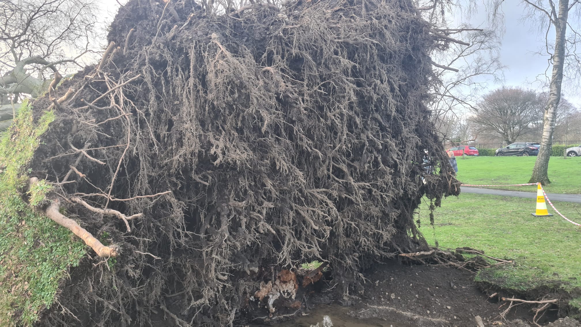
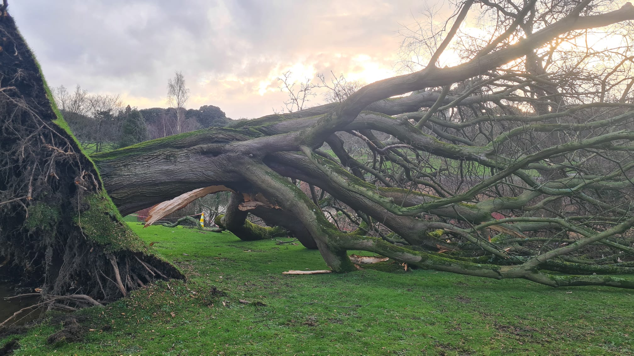
In pictures: An uprooted tree in Dublin
Wednesday 28 January 2026 20:30 , Shaheena UddinRivers burst their banks, including the Slaney in Co Wexford and the Dodder in Dublin, with fallen trees reported across the island.
Storm Chandra sparks disruption across train network with GWR and ScotRail hit
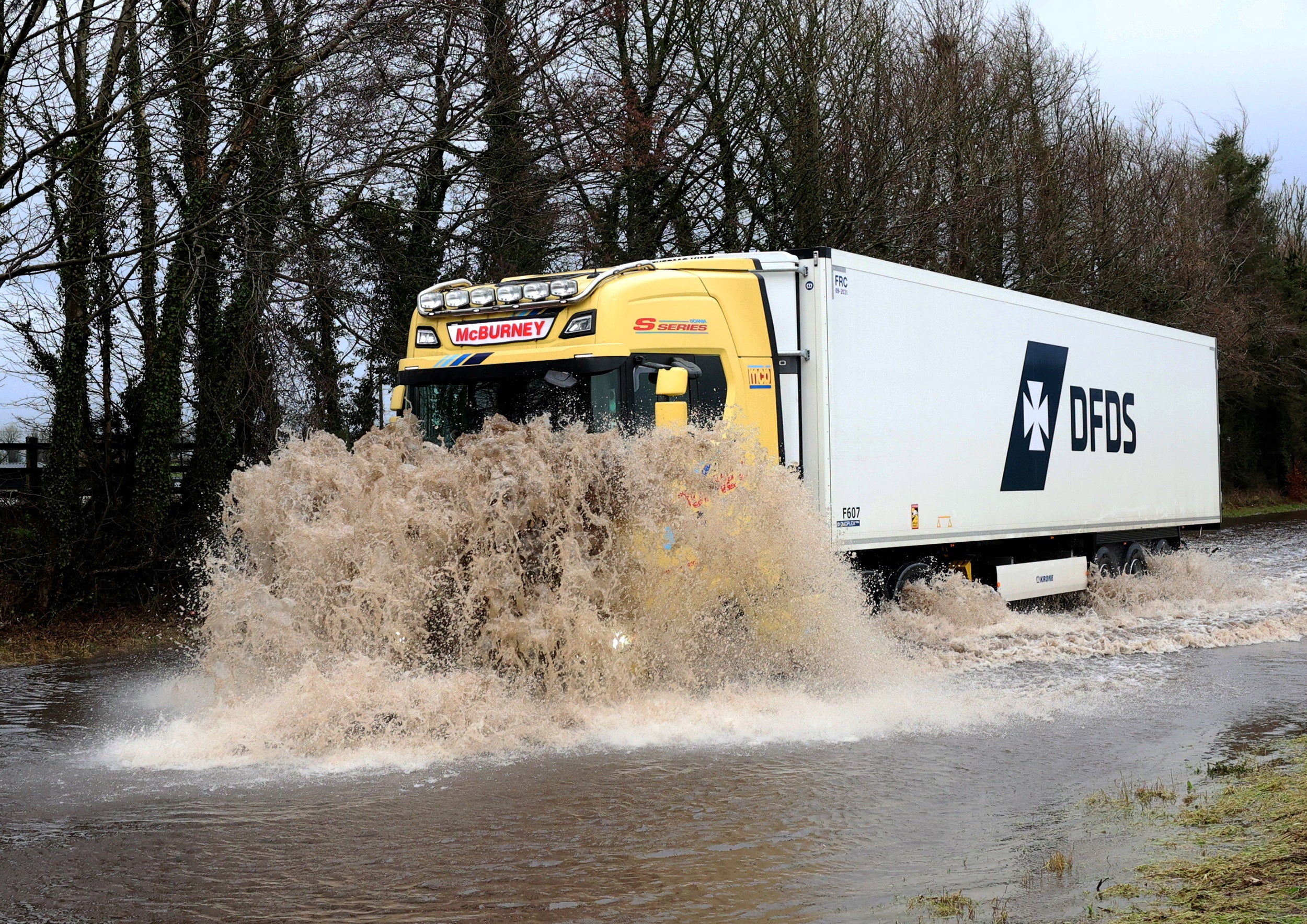
Wednesday 28 January 2026 20:00 , Shaheena UddinTravel misery is set to continue for days for people in southwest England – with transport chaos continuing around the rest of the UK.
Following on from Storm Chandra, the Met Office has issued a Yellow weather warning for rain across Cornwall, Devon, Dorset and into Somerset and Wiltshire.
The Independent’s Travel correspondent, Simon Calder, reports:

Storm Chandra sparks disruption across train network with GWR and ScotRail hit
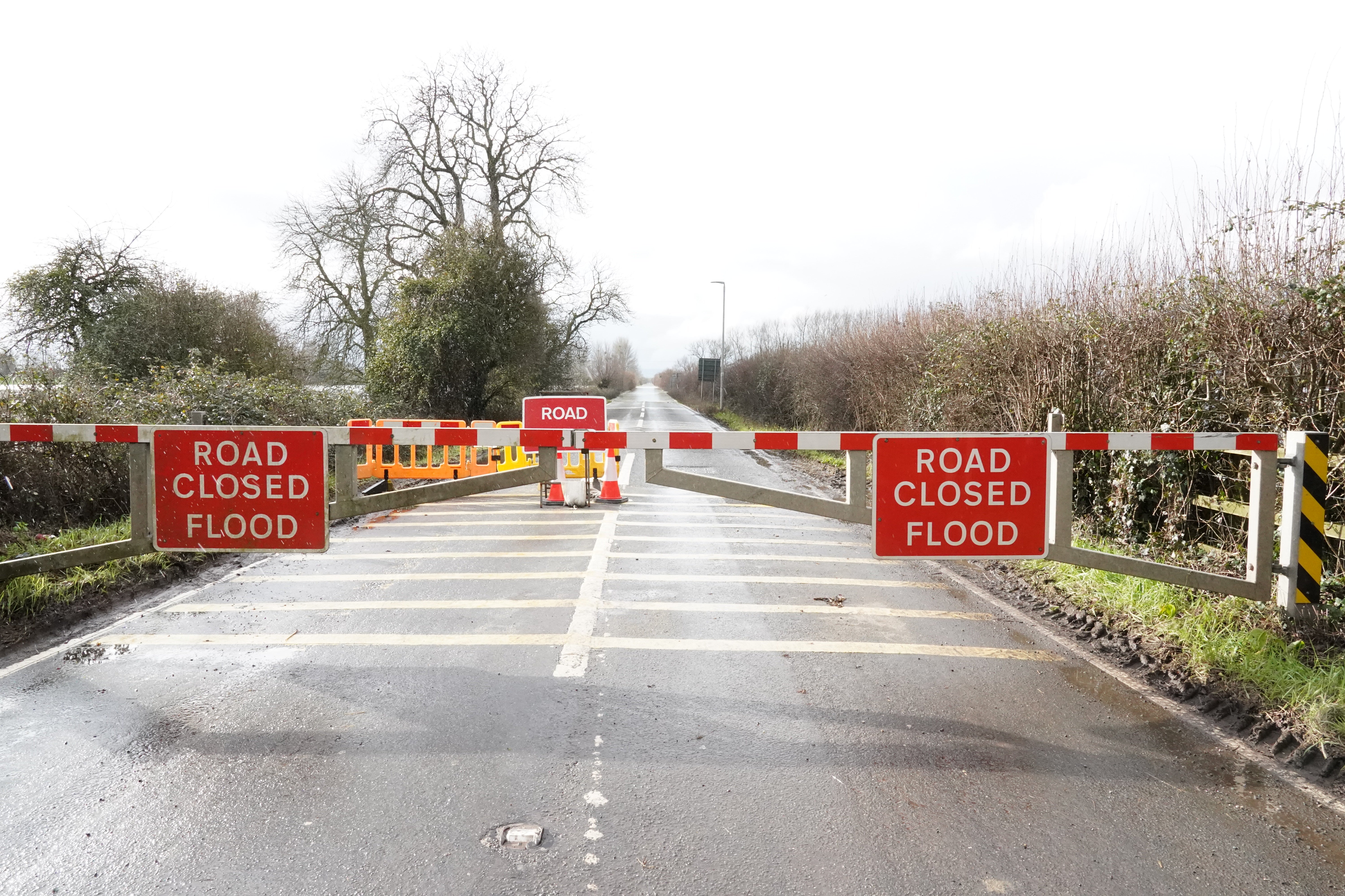
Road closures in Somerset due to flooding
Wednesday 28 January 2026 19:30 , Shaheena UddinSeveral roads have been closed in Somerset due to flooding:
- Devon - M5 - One lane closed and slow traffic due to emergency repairs and flooding on M5 Southbound from J28 A373 Honiton Road (Cullompton / Service Area) to J29 A30 Honiton Road (Exeter / Honiton).
- Podimore - A303 - One lane closed due to flooding on A303 Westbound from A37 (Podimore Roundabout, Podimore) to A3088 (Cartgate Roundabout, Stoke Sub Hamdon). Traffic is coping well.
- Burrowbridge - A361 New Road - A361 New Road both ways closed due to flooding between Stathe Road (Burrowbridge) and Cuts Road (East Lyng).
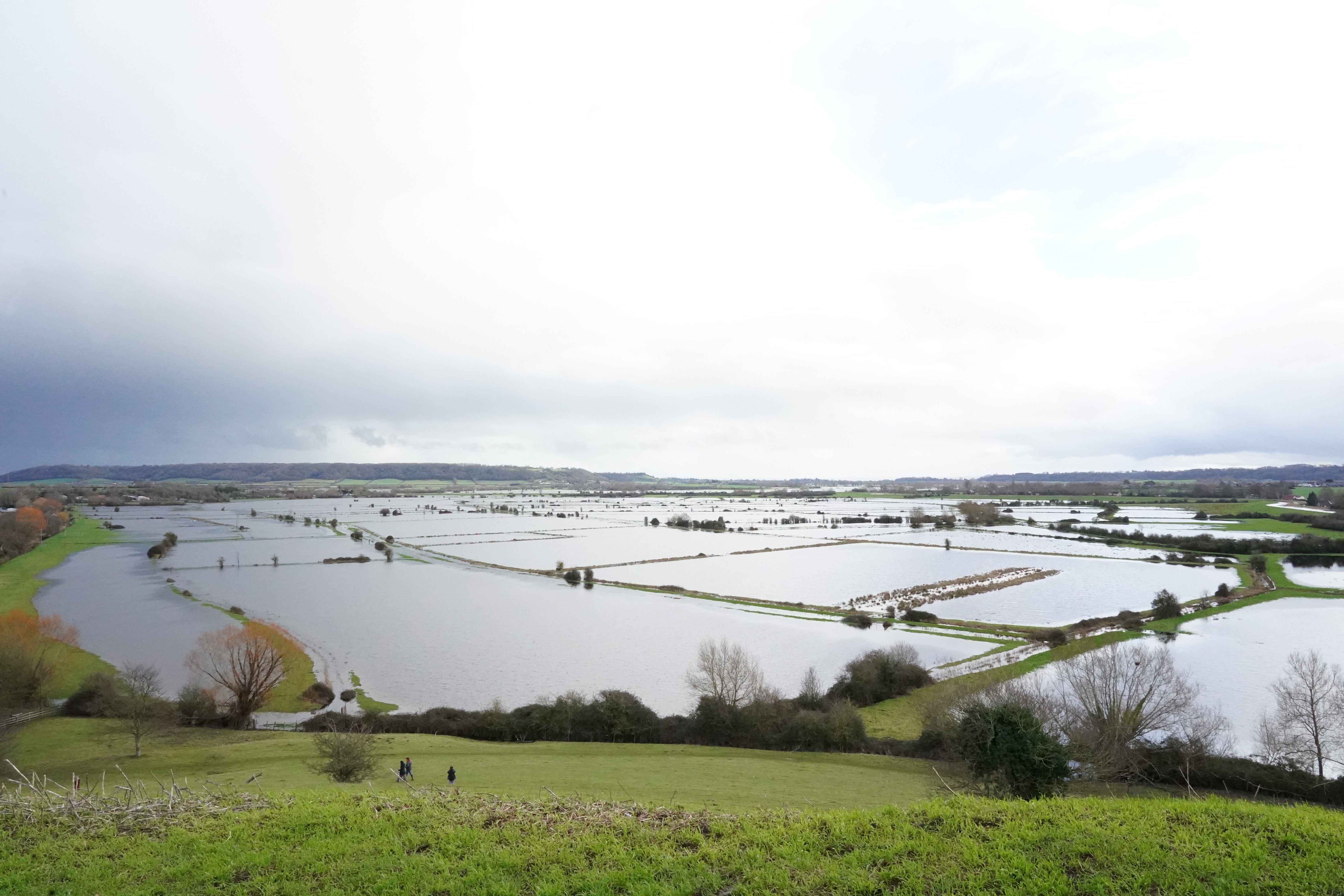
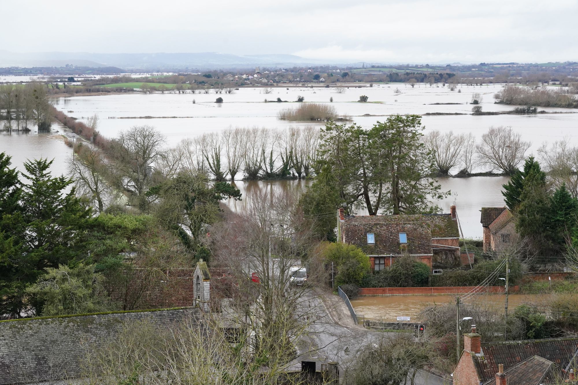
Retired couple fear 'scariest' floods in over a decade
Wednesday 28 January 2026 19:00 , Shaheena UddinA retired couple based on the Somerset Levels, where a “major incident” was declared on Tuesday, fear heavy rainfall on Thursday could bring the worst flooding in over a decade.
Lesley and John Parker, who live in the village of Burrowbridge, Somerset, have installed flood defences around their home in the hopes of containing the water, which they worry will come “straight up through the floor”.
Mr and Mrs Parker said the conditions are the scariest they have seen since their home was devastated by flooding in 2014, when 3ft of water inside the house forced them to evacuate.
The couple said they have been mostly “left to (their) own devices”, and believe the Environment Agency has done “too little too late” to save their home of 14 years.
Mr Parker said: “The thing was, in 2014, the whole process was much slower, it was almost like slow motion.
“Whereas this has happened so fast that nothing has actually been set up yet.”
On Wednesday, the couple installed a flood barrier provided by their local rotary club and stuffed sandbags outside the entrances to their home.
A spokesman for the Environment Agency said: “Our incident response has been ahead of the curve – not behind it. Staff have been working hard 24/7 to protect people and property.”
A 'major incident' of flooding in Somerset
Wednesday 28 January 2026 18:30 , Shaheena UddinIn Somerset, a major incident was declared on Tuesday after Storm Chandra caused flooding to roads and properties.
Somerset Council said an estimated 50 properties had been affected by flooding across Ilminster, West Coker, Taunton, Mudford and West Camel.
Council leader Bill Revans said: “The weather forecast remains challenging so we will be working with colleagues in the emergency services to ensure we are prepared should the situation continue to deteriorate.”
What is causing all the wet weather?
Wednesday 28 January 2026 18:00 , Shaheena UddinWondering what's causing all the wet weather? pic.twitter.com/jxIfcFuRA3
— Met Office (@metoffice) January 28, 2026
Dorset council issues severe hazard alert after road blocked
Wednesday 28 January 2026 17:30 , Shaheena UddinDorset council have issued a severe hazard incident alert in West Parley, Bournemouth.
The A347 New Road is currently blocked both ways with queueing traffic after the River Stour bridge.
On Wednesday, a severe flood warning was issued for the Lower Stour at Iford Bridge Home Park, where residents were told to evacuate their properties “as soon as possible” and to pack an overnight bag with any essential items such as medications.
Staff from Bournemouth borough council and emergency services are onsite to assist residents. Residents were also advised to move family, pets and cars to safety and turn off gas, electricity and water if it is safe to do so.
River levels are forecasted to be higher than November 2024, peaking at 3.66m at approximately 2pm on Wednesday 28 January.
Environment Agency warns to 'stay vigilant' as flooding risk continues
Wednesday 28 January 2026 17:00 , Shaheena UddinThe Environment Agency has informed people to remain vigilant to the risk of flooding as further yellow rain warnings come into place as a result of Storm Chandra.
Weather conditions are forecasted to remain unsettled for Thursday and Friday, as the Met Office issued warnings across both days in the south of England and Northern Ireland on Friday.
An estimated 63 properties across England have been flooded, and almost 10,900 protected through Environment Agency action, a spokesman said.
On Wednesday, a severe flood warning was issued for the Lower Stour at Iford Bridge Home Park, where residents were told to evacuate their properties “as soon as possible”.
Chris Wilding, flood duty manager at the Environment Agency, said: “Our thoughts are with all those affected by Storm Chandra, including those whose homes and businesses have sadly been flooded.
“Significant river flooding impacts are probable in parts of the south west of England today. Further flooding impacts are also expected for parts of England on Thursday and into early Friday morning.
“Environment Agency teams are out on the ground, including in Somerset, to reduce the impact of flooding and support those communities affected.
“We urge people not to drive though flood water – it is often deeper than it looks and just 30cm of flowing water is enough to float your car.”
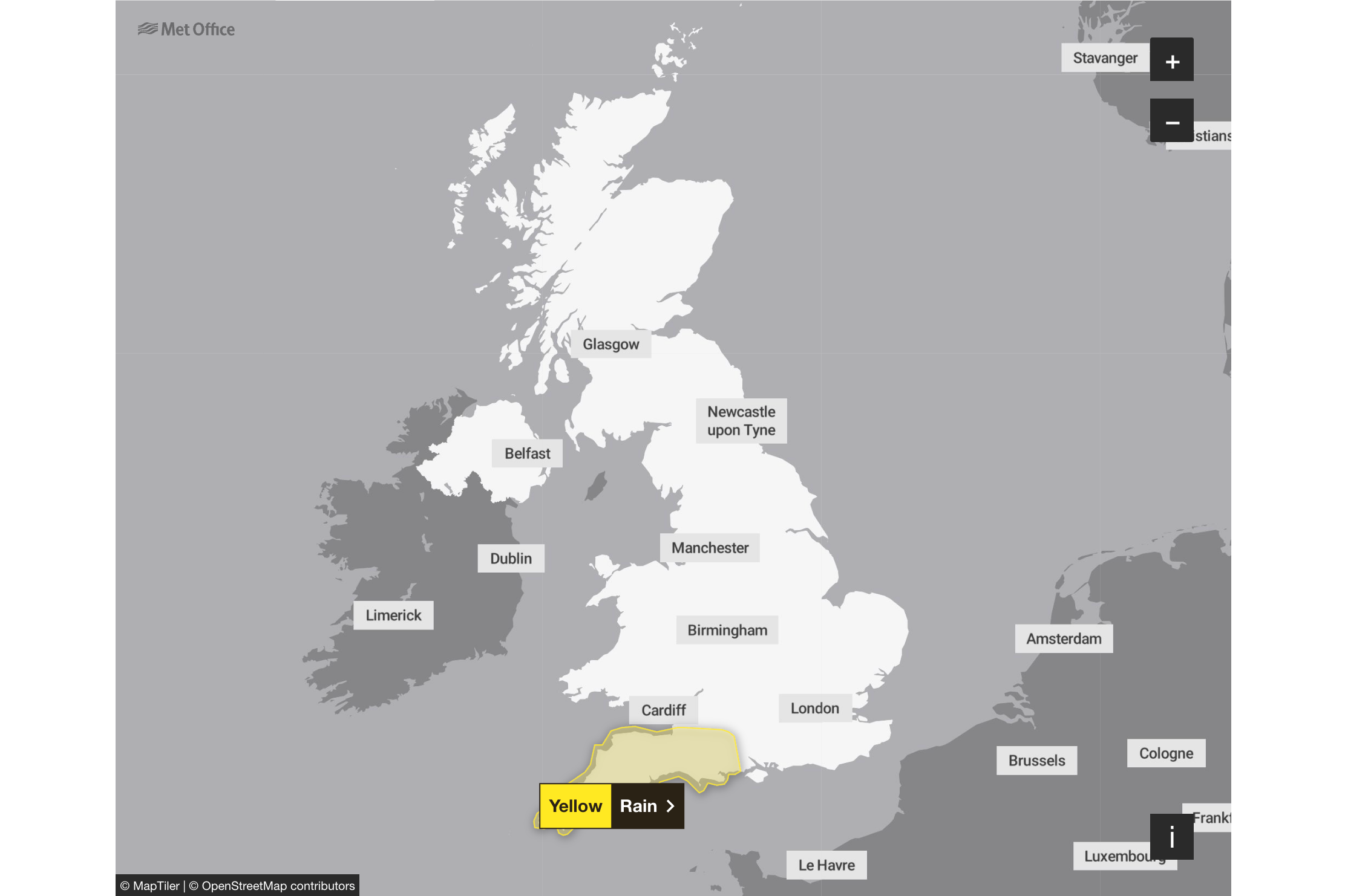
Yellow weather warning issued for Thursday
Wednesday 28 January 2026 16:30 , Shaheena UddinThe Met Office issued a yellow weather warning for rain to begin at noon on Thursday and continue until 3am on Friday.
The forecasters predict this further rain to lead to some travel disruption and intensify flooding in some areas. Spray and flooding on roads may make journey times longer, impacting bus and train services, as well as affecting some homes and businesses.
The national weather service said: “A band of rain will arrive across Cornwall on Thursday afternoon then move northeast across the warning area through the evening and clearing during early Friday.
“The rain is only likely to last for a few hours in any one location but will be at heavy at times. A further 10-15 mm of rain is expected fairly widely, but some locations, most likely in the south of the area, could see 20-25 mm.
“The likelihood of impacts from these rainfall amounts is higher than normal due to saturated ground and ongoing flooding following Storm Chandra.”
UK five day weather forecast
Wednesday 28 January 2026 16:15 , Shaheena UddinThe Met Office has forecasted that the rest of this week will remain rather cloudy, with possible showers predicted on Thursday.
Wednesday evening:
Low cloud and fog forming across many eastern and central areas overnight, with some patchy rain possible where the cloud is thickest. Elsewhere, a few clear spells and some patchy frost are likely, although occasional showers may affect the southwest.
Thursday:
Rather cloudy and breezy with some rain and hill snow lingering in the northeast, whilst showers give way to more persistent rain towards the southwest. Some brighter breaks developing elsewhere.
Outlook for Friday and the weekend:
Friday looks unsettled with brisk winds. Rather cloudy skies giving outbreaks of rain for many. Brighter and becoming less breezy for most over the weekend, albeit with scattered showers still.
Watch: River Slaney burst its banks as Storm Chandra batters Ireland
Wednesday 28 January 2026 16:00 , Shaheena UddinFurther rain warnings issued for Ireland as clean up under way at flood-hit town
Wednesday 28 January 2026 15:41 , Holly EvansNew rain warnings have been issued as communities hit by heavy flooding earlier in the week assess the damage.
Met Eireann has issued a Status Yellow rain warning for counties Dublin, Carlow, Kilkenny, Wexford, Wicklow, and Waterford which will be in effect all day Thursday.
The Irish forecaster warned that heavy rain, combined with saturated grounds and high river levels, could lead to more flooding.
A Yellow-level rain warning has also been issued by the Met Office for Northern Ireland, from midnight until 6pm on Friday.
The warnings come as the clean up begins in areas hit by heavy flooding earlier in the week caused by Storm Chandra.
Heavy winds and torrential rain on Tuesday caused significant disruption across the island of Ireland, including power outages, flight cancellations and 300 school closures in Northern Ireland.
Rivers burst their banks, including the Slaney in Co Wexford and the Dodder in Dublin, with fallen trees reported across the island.
Watch: 'Danger to life' warnings issued across UK and Ireland
Wednesday 28 January 2026 15:22 , Holly EvansMore heavy rain forecasted to hit Northern Ireland
Wednesday 28 January 2026 15:04 , Holly EvansThe Met Office have warned that further heavy rain is forecast to hit Northern Ireland in the coming days.
A yellow warning for rain in place from midnight until Friday evening, with any rain again falling on saturated ground.
The wettest conditions are likely to be over Antrim and Down, with potential for many areas to see 10-25 mm of rainfall, with 40-60 mm over some hills.
⚠️ Yellow weather warning issued ⚠️
— Met Office (@metoffice) January 28, 2026
Further rain across Northern Ireland falling on already saturated ground
Friday 00:00 – 18:00
Latest info 👉 https://t.co/QwDLMfRBfs
Stay #WeatherAware⚠️ pic.twitter.com/pdqAax2BbW
'Nobody seems to do anything about it,' says Dorset resident
Wednesday 28 January 2026 14:37 , Holly EvansAnn Mallett, who has gone to stay with her family after being evacuated from the Iford Bridge Home Park, near Christchurch in Dorset, said flood alleviation measures needed installing at the park after the latest incident.
“It’s obviously going to get worse every year and nobody seems to do anything about it,” she told the Press Association.
“We are OK because we are over to our sons to stay, but some people don’t have that.
“It’s just a flipping nuisance really.
“They have switched the electricity off and I did a big shop about a week ago. I should not have done really.”
Multiple ferry sailings cancelled in the Channel
Wednesday 28 January 2026 14:19 , Holly EvansIn the English Channel, Brittany Ferries has cancelled Wednesday sailings from Poole both Cherbourg and Bilbao in Spain.
DFDS Ferries has cancelled multiple services linking Jersey with Portsmouth and St-Malo, but an additional round-trip from the Channel Island to the French port is scheduled for Thursday.
Caledonian MacBrayne ferries in the Western Isles of Scotland continue to be disrupted “due to forecast strong winds and sea swell”.
Affected routes include the link from Oban to Barra. Calmac warns: “Sailings are at a heightened risk of disruption or cancellation at short notice.”
Dorset resident evacuated from home experienced flooding in 2013
Wednesday 28 January 2026 14:10 , Holly EvansResident Martin Sadler, who was among those evacuated from the Iford Bridge Home Park, near Christchurch in Dorset, told the Press Association: “I was there in 2013 and my home was flooded then.
“Subsequent to that the homes were raised by about 65cms.
“I feel quite safe actually now that the home is safe from flooding.
“I think they are turning the electricity off, and so that’s a bit difficult to be comfortable without that.
“I stayed there until it got a bit risky and I left. I left before I got wet feet.”
Lorry driver dies after crashing into river in Hampshire
Wednesday 28 January 2026 13:58 , Holly EvansA lorry driver died in the New Forest after crashing into a river on Tuesday in the aftermath of Storm Chandra.
Hampshire Police said a man, who was in his 60s, was pronounced dead at the scene of the incident in North Gorley.
“We were called just after 1pm on Tuesday to a report that a lorry had gone into a river off Ringwood Road in North Gorley,” a force spokesman said.
“Sadly the driver, a man in his 60s, was pronounced deceased at the scene.
“Inquiries are ongoing to establish the circumstances surrounding his death.”
Full list of UK schools closed today as Storm Chandra brings ‘extensive’ flooding and ice warnings
Wednesday 28 January 2026 13:45 , Holly EvansHundreds of schools across the UK remain closed today as Storm Chandra continues to bring dangerous conditions and nearly 100 flood warnings.
Over 350 schools are now confirmed to be closed in Northern Ireland, while dozens remain shut across the South West of England.
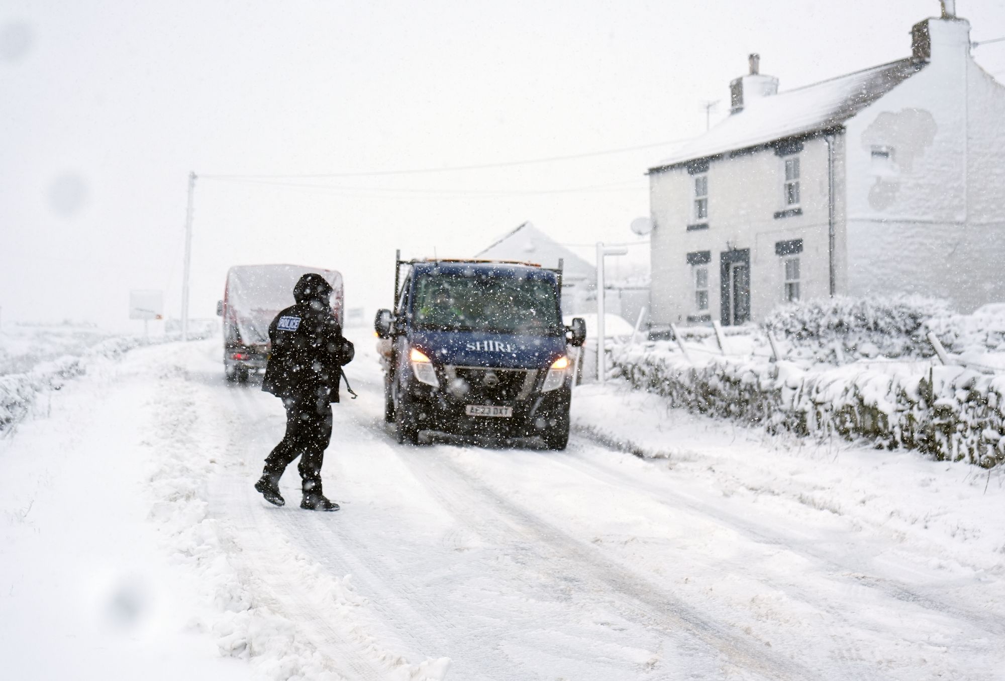
Northern Ireland is experiencing severe weather, with yesterday’s amber warning being replaced with an ice warning that covers all regions.
Read the full article here:
Full list of UK schools closed today as Storm Chandra brings flooding and ice warning
In pictures: Flooding in Northamptonshire
Wednesday 28 January 2026 13:25 , Holly Evans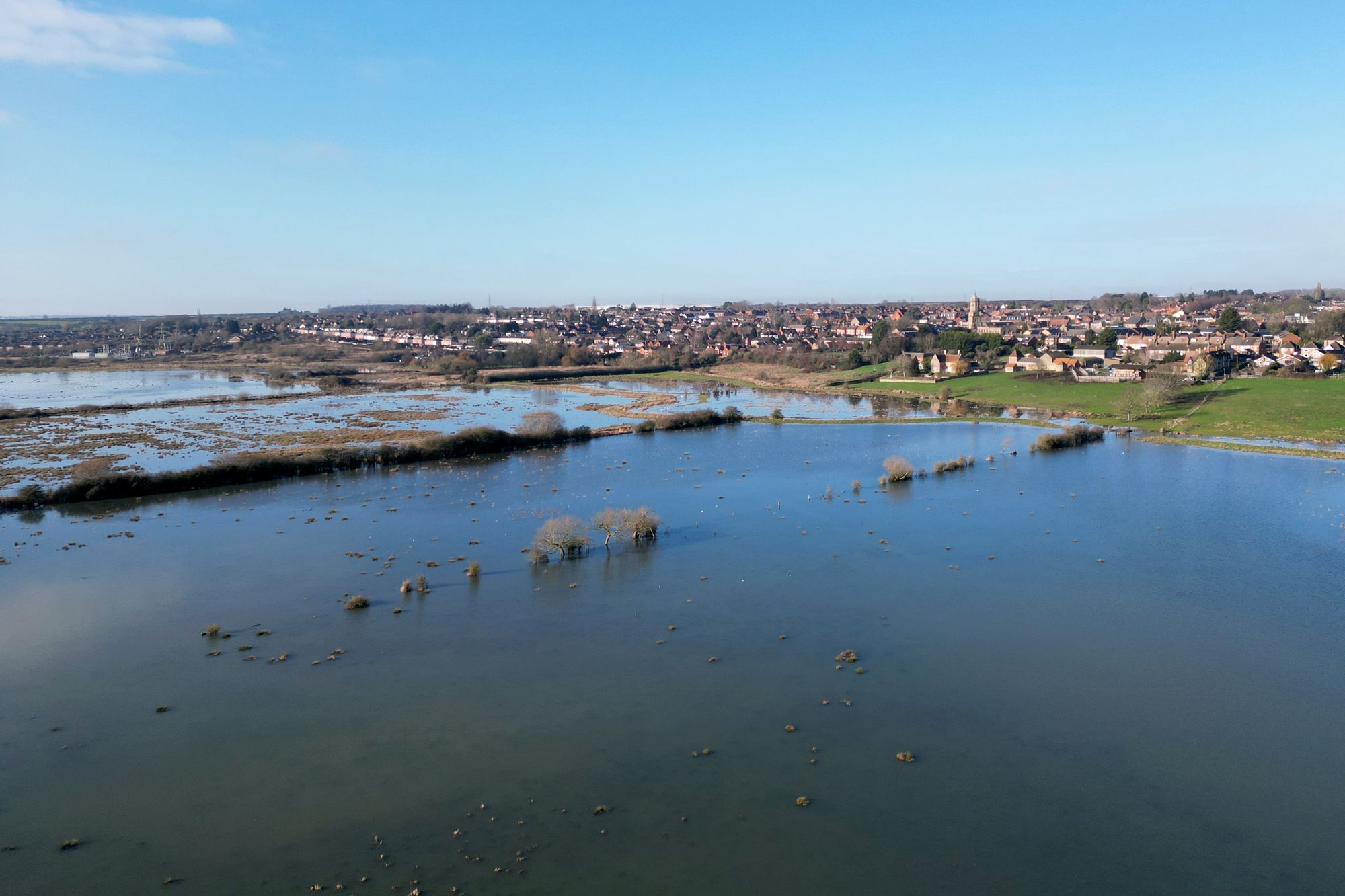
Storm Chandra sparks disruption across train network with GWR and ScotRail hit
Wednesday 28 January 2026 13:00 , Holly EvansTravel misery is set to continue for days for people in southwest England – with transport chaos continuing around the rest of the UK.
Following on from Storm Chandra, the Met Office has issued a Yellow weather warning for rain across Cornwall, Devon, Dorset and into Somerset and Wiltshire.
Forecasters say: “Further rain on Thursday afternoon to early Friday is expected to lead to some transport disruption and exacerbate flooding in places.”
These are the key locations experiencing transport chaos.
Read the full article from Simon Calder here:
Storm Chandra sparks disruption across train network with GWR and ScotRail hit
Fire chiefs call on government to establish funding framework for flooding response
Wednesday 28 January 2026 12:35 , Holly EvansFire chiefs are warning that the flood risk in England is rising faster than the legal and funding framework in place to support the emergency response.
The National Fire Chiefs Council has called on the Government to consult on establishing a statutory duty for fire and rescue services in England to respond to flooding incidents which pose a risk to life.
Council chairman Phil Garrigan said: “Firefighters routinely carry out water rescues, evacuate residents and support communities during major flooding events, and they will continue to do so because that is what the public rightly expects.
“But as climate change drives more frequent and severe flooding, it is no longer credible for this life-saving work to sit outside a clear statutory framework.
“England is increasingly exposed to flood risk, yet fire and rescue services are being asked to respond without the legal clarity or funding that exists elsewhere in the UK.”
Heavier rain to hit the south-west on Thursday
Wednesday 28 January 2026 12:19 , Holly EvansMatthew Lehnert, Chief Meteorologist at the Met Office said: “On Thursday, showers in southwest England will be replaced by a more organised area of rain when the next system reaches the south of Cornwall around Thursday lunchtime.
“There’s a Yellow Warning for rain in place from noon until Friday morning, with the focus for heavier rain across southwest England as the wet conditions spread northeast across the warning area.
“The rain is only likely to last for a few hours in each location but will be heavy at times. 10 to 15 mm is likely quite widely, but in some areas, particularly towards the south coast, a further 20 to 25 mm is possible.
“This rain will fall onto already saturated ground, compounding the impacts of Storm Chandra, so we’re encouraging people to stay up to date with the latest forecast and follow any advice from the emergency services and local authorities.”
⚠️ Yellow weather warning UPDATED ⚠️
— Met Office (@metoffice) January 28, 2026
Further rain across southwest England falling on already saturated ground
Thursday 12:00 – Friday 03:00
Latest info 👉 https://t.co/QwDLMfRBfs
Stay #WeatherAware⚠️ pic.twitter.com/K1BaELgrhx
Landslip and flooding causes chaos in Somerset
Wednesday 28 January 2026 11:56 , Holly EvansMultiple road closures were in force across Somerset due to flooding, a landslip and a tree being down, with eight schools in the county also closed.
In Somerset, nine schools were closed because of the weather.
Meanwhile, in Devon, Storm Ingrid caused a large sinkhole measuring eight metres x 3.5 metres to appear near the railway line between Dawlish and Teignmouth.
The line will be closed between Exeter St Davids and Newton Abbot overnight on Wednesday for repairs.
There is also disruption to rail services in Cornwall, Devon and Somerset as a result of flooding.
In pictures: Residents at a caravan park evacuated
Wednesday 28 January 2026 11:40 , Holly Evans

Residents in Dorset told to pack overnight bags ahead of potential flooding
Wednesday 28 January 2026 11:11 , Holly EvansStaff from Bournemouth, Christchurch and Poole Council (BCP Council) are at a home park in Dorset that is at risk of flooding, to help residents evacuate.
Residents were told to pack a bag with essential items such as medications and prepare to be away from their properties overnight.
Power to the site, which has 80 homes, is expected to be impacted by flooding.
The Environment Agency told residents: “Move family, pets and cars to safety and turn off gas, electricity and water if it is safe to do so.”
River levels are expected to peak at 3.66m at approximately 2pm on Wednesday, it added.
Residents evacuated as danger to life flood warning issued in Dorset
Wednesday 28 January 2026 11:01 , Holly EvansResidents at a caravan park in Dorset have been told to evacuate their properties “as quickly as possible” as a severe flood warning is in place due to Storm Chandra.
Severe flooding, with “deep and fast flowing” water, is expected at Iford Bridge Home Park near Christchurch, Dorset as levels on the River Stour rise.
The Environment Agency issued the severe flood warning – meaning danger to life – on Wednesday morning.
It said: “Severe flooding is expected today and flood water is expected to be deep and fast flowing.
“Flooding is expected on January 28 2026.
“River levels are rising and require residents to evacuate as quickly as possible.”
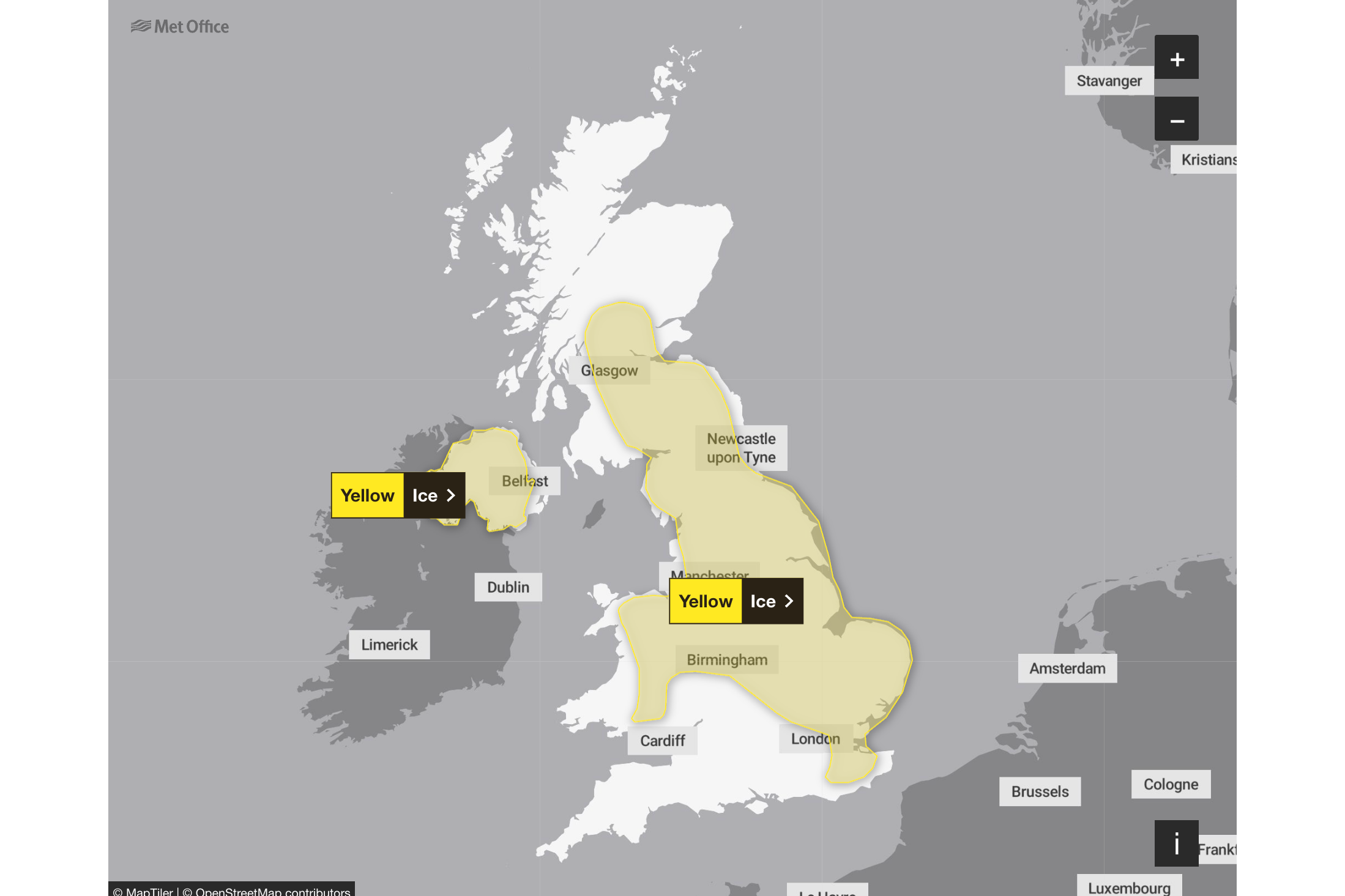
Two yellow weather warnings issued for Friday
Wednesday 28 January 2026 10:50 , Holly EvansFresh yellow weather warnings have been issued for Friday, as the UK continues to face heavy rainfall in the aftermath of Storm Changra.
The Met Office have issued a warning for Northern Ireland lasting from midnight until 6pm, while another warning has been issued for south-west England from midnight on Thursday until 3am on Friday.
The forecaster warned that spells of heavy rain could lead to some transport disruption and flooding in places.
Railway disruption continues in Scotland
Wednesday 28 January 2026 10:20 , Holly EvansDisruption continues on railway lines across Scotland, with ScotRail warning that speed restrictions are imposed.
On social media, they warned: “Lines may also be disrupted as a result of debris being blown onto the track, or fallen trees.”
⚠️Severe weather is causing disruption to services running on various routes across the ScotRail network.
— National Rail (@nationalrailenq) January 28, 2026
▪️To allow trains to travel safely through areas impacted by the poor weather, speed restrictions may be imposed. Lines may also be disrupted as a result of debris being…
Watch: River Slaney burst its banks as Storm Chandra batters Ireland
Wednesday 28 January 2026 09:58 , Holly EvansSomerset Council warn that weather 'remains challenging'
Wednesday 28 January 2026 09:42 , Holly EvansSomerset Council said on Tuesday evening that an estimated 50 properties have been affected by flooding across Ilminster, West Coker, Taunton, Mudford and West Camel.
Council leader Bill Revans said: “The decision to declare a major incident at this stage means we are well placed to respond to this ongoing situation.
“Storm Chandra brought more than 50mm of rain to parts of Somerset last night, on top of already saturated land, and this has caused widespread disruption.
“Please avoid travelling if you can and never attempt to drive through flood water.
“The weather forecast remains challenging so we will be working with colleagues in the emergency services to ensure we are prepared should the situation continue to deteriorate.”
Met Office issues advice for icy conditons
Wednesday 28 January 2026 09:23 , Holly EvansWith two yellow weather warnings in place for ice across the UK, the Met Office has issued tips for staying warm and guidance for those looking to travel.
- Avoid travel if possible
- If you must drive check the Highway Code for advice on driving in ice and snowy weather. A summary of the advice is: Take care around gritters. Don't be tempted to overtake. Slow down - it can take 10 times longer to stop in snowy or icy conditions, so allow extra room. Use the highest gear possible to avoid wheel spin. Manoeuvre gently and avoid harsh braking and acceleration. If you start to skid, gently ease off the accelerator and avoid braking. If braking is necessary, pump the brakes don't slam them on. If you get stuck, stay with your car and tie something brightly coloured to your aerial
- If you go outside wear several layers of clothing and keep dry to prevent loss of body heat. Watch out for signs of hypothermia - uncontrollable shivering, slow/slurred speech, memory lapse and drowsiness and frostbite - loss of feeling in and pale appearance of fingers, toes, nose and ear lobes. Keep moving your arms and legs to help the blood circulate
- Be aware of black ice. It isn't always visible and so can be an even greater hazard for both motorists and pedestrians. Black ice may be formed when rain or drizzle fall on a road surface which is at a temperature below zero
Full list of UK schools closed today as Storm Chandra causes disruption
Wednesday 28 January 2026 09:14 , Holly EvansHundreds of schools across the UK remain closed today as Storm Chandra continues to bring dangerous icy conditions and nearly 100 flood warnings.
Over 350 schools are now confirmed to be closed in Northern Ireland, while dozens remain shut across the South West of England.
Read the full article here:
Full list of UK schools closed today as Storm Chandra continues to cause disruption
What is the five day weather forecast?
Wednesday 28 January 2026 08:56 , Holly EvansHere’s a look at the five day weather forecast:
Today:
Fog and ice will clear leaving most places dry with sunny spells. However, the north and east of Scotland will have patchy rain and mountain snow, and Northern Ireland, southwest Wales and southwest England will be breezy with some showers.
Tonight:
Low cloud and fog forming across many eastern and central areas overnight, with patchy rain. Hill snow northeast Scotland. Breezy, with showers in the southwest. Frost under clearer spells elsewhere.
Thursday:
Rather cloudy and breezy with some rain and hill snow lingering in the northeast, whilst showers give way to more persistent rain towards the southwest. Some brighter breaks developing elsewhere.
Outlook for Friday to Sunday:
Friday looks unsettled with brisk winds. Rather cloudy skies giving outbreaks of rain for many. Brighter and becoming less breezy for most over the weekend, albeit with scattered showers still.
Two ice warnings remain in place
Wednesday 28 January 2026 08:39 , Holly EvansTwo ice warnings remain in place until 10am covering vast areas of the UK, with the Met Office warning that patchy ice is likely to form on untreated surfaces.
They cover Northern Ireland, central Scotland, the Midlands, the east of England, London and the South East, the north of England and parts of Wales.
“Clearing skies Tuesday night will allow temperatures to fall below freezing soon after midnight and on Wednesday morning.
“After the recent wet weather, icy patches are likely to develop on some untreated surfaces,” a Met Office spokesperson said
National Rail warn of disruptions until Friday
Wednesday 28 January 2026 08:23 , Holly EvansGreat Western Railway advised passengers not to travel between Exeter St Davids and both Okehampton and Barnstaple, with services in Somerset and Cornwall cancelled on Wednesday.
ScotRail said speed restrictions were expected to remain on services between Edinburgh, Inverness and Glasgow Queen Street until 10am on Wednesday, while National Rail warned of disruptions until Friday.
STORM CHANDRA: 0615
— GWR (@GWRHelp) January 28, 2026
We’re really sorry to those impacted by disruption due to flooding on our network.
Please check your journey before you travel at https://t.co/MbUMtXXr1G where you can see full information on all lines affected.
Tickets for today will be valid tomorrow and… pic.twitter.com/XymtI1P1bJ
Devon and Cornwall trains: Severe disruption continues
Wednesday 28 January 2026 08:02 , Simon CalderThe Great Western rail network is in disarray in Devon and Cornwall due to Storm Chandra. Rail firm GWR says: “Back-to-back storms have brought persistent heavy rain and widespread flooding across the region, forcing the closure of several rail lines.”
The links from Exeter St Davids to Barnstaple and Okehampton in Devon are closed, as are the Cornish lines from Liskeard to Looe and Par to Newquay.
GWR is telling passengers: “Poor road conditions mean bus replacement services cannot be provided on these routes at this stage. Should conditions improve, replacement bus services will be provided where possible. These branch lines are likely to remain closed for several days and no rail services will operate.”
Further disruption awaits, with the Night Riviera sleeper train between London Paddington and Penzance cancelled in both directions on Wednesday night.
The rail firm said: “Following Storm Ingrid, a large sink hole has appeared near the railway between Dawlish and Teignmouth. The railway line will be closed between Exeter St Davids and Newton Abbot from 7pm on Wednesday 28 January to allow the work to take place and will reopen at 7am on Thursday 29 January.
“Services will continue to run between London and Exeter St Davids and Penzance and Newton Abbot.
Some good news: the main line from the capital has just reopened between Taunton and Exeter St Davids. It was previously closed “due to deep, fast-moving floodwater”.
Schools remain closed in Devon and Somerset
Wednesday 28 January 2026 07:45 , Holly EvansA number of schools have remained closed for the second day in the wake of Storm Chandra, as heavy rain caused widespread flooding in the south-west of England.
According to the council website, 12 schools remain closed or partially closed in Somerset, while 4 remain shut in Devon.
Reasons given to parents include local flooding resulting in staff being unable to reach the premises.
Hundreds of flood warnings in place after Storm Chandra
Wednesday 28 January 2026 07:34 , Holly EvansHundreds of flood warnings and alerts are in place after Storm Chandra brought heavy rain across the country.
A major incident was declared in Somerset on Tuesday evening, with the council stating that the risk of flooding on the Somerset Levels and Moors “remains high as rainwater moves through the system”.
On Wednesday morning, there were 99 flood warnings, where flooding is expected, and 260 flood alerts, where it is possible, across England.
In Wales, there were three flood warnings and 16 flood alerts in place, while there were eight flood warnings and eight flood alerts in place across Scotland.
The Met Office shares forecast maps for Wednesday
Wednesday 28 January 2026 06:00 , Shaheena UddinAs #StormChandra clears away, find out what will be in the 4cast for tomorrow 👇 pic.twitter.com/JkQW9QANyk
— Met Office (@metoffice) January 27, 2026
In pictures: An uprooted tree in Dublin
Wednesday 28 January 2026 21:12 , Shaheena UddinRivers burst their banks, including the Slaney in Co Wexford and the Dodder in Dublin, with fallen trees reported across the island.
What is the four day weather forecast?
Wednesday 28 January 2026 05:06 , Holly EvansHere’s a look at the four-day weather forecast:
Today:
Patchy fog in the east at first. Outbreaks of showery rain possible in the southwest and northeast, otherwise dry for many with some sunny spells. Breezy, but generally less windy.
Outlook for Thursday to Saturday:
Staying unsettled with further showers or longer spells of rain, particularly in the southwest and eastern Scotland. Some drier interludes too, particularly in the east. Feeling chilly in brisk winds.
Recap: Heavy rain and floods batter Ireland as tens of thousands remain without power
Wednesday 28 January 2026 05:00 , Shaheena UddinHundreds of schools were closed and tens of thousands of people are without power on Tuesday as Storm Chandra battered the island of Ireland.
There were also travel disruptions caused by the strong winds and torrential rain.
In Northern Ireland more than 300 schools were closed and there was a yellow rainfall alert in place for counties Armagh, Down, Fermanagh, Londonderry and Tyrone.
Storm Chandra map: Where heavy rain and flooding could hit UK today with ‘danger to life’ warning issued
Wednesday 28 January 2026 04:00 , Shaheena UddinStrong winds, heavy rain and snow are forecast across much of the UK on Tuesday, the Met Office has warned, as the newly named Storm Chandra brings weather chaos.
Storm Chandra is expected to hit with “very strong winds”, which may damage buildings and dislodge tiles that could cause life-threatening injuries.
Several weather warnings have been issued, including an amber warning for wind along the east coast of Northern Ireland and including Belfast.
The Independent reporter Shaheena Uddin writes:
Storm Chandra map: Where flooding could hit today with ‘danger to life’ warning
Storm Chandra sets new January daily rainfall records in several places
Wednesday 28 January 2026 03:00 , Shaheena UddinThe Met Office have announced that several sites have provisionally set new January daily rainfall records due to Storm Chandra.
Plymouth (Mountbatten) has set a new record despite over 100 years of observations, while Katesbridge has provisionally recorded its wettest day on record with 100.8mm of rain.
Several sites have provisionally set new January daily rainfall records, some are shown in the table below 👇
— Met Office (@metoffice) January 27, 2026
Katesbridge has provisionally recorded its wettest day on record, while Plymouth (Mountbatten) also saw a notable record at a site with over 100 years of observations pic.twitter.com/9zFGBsoUYi
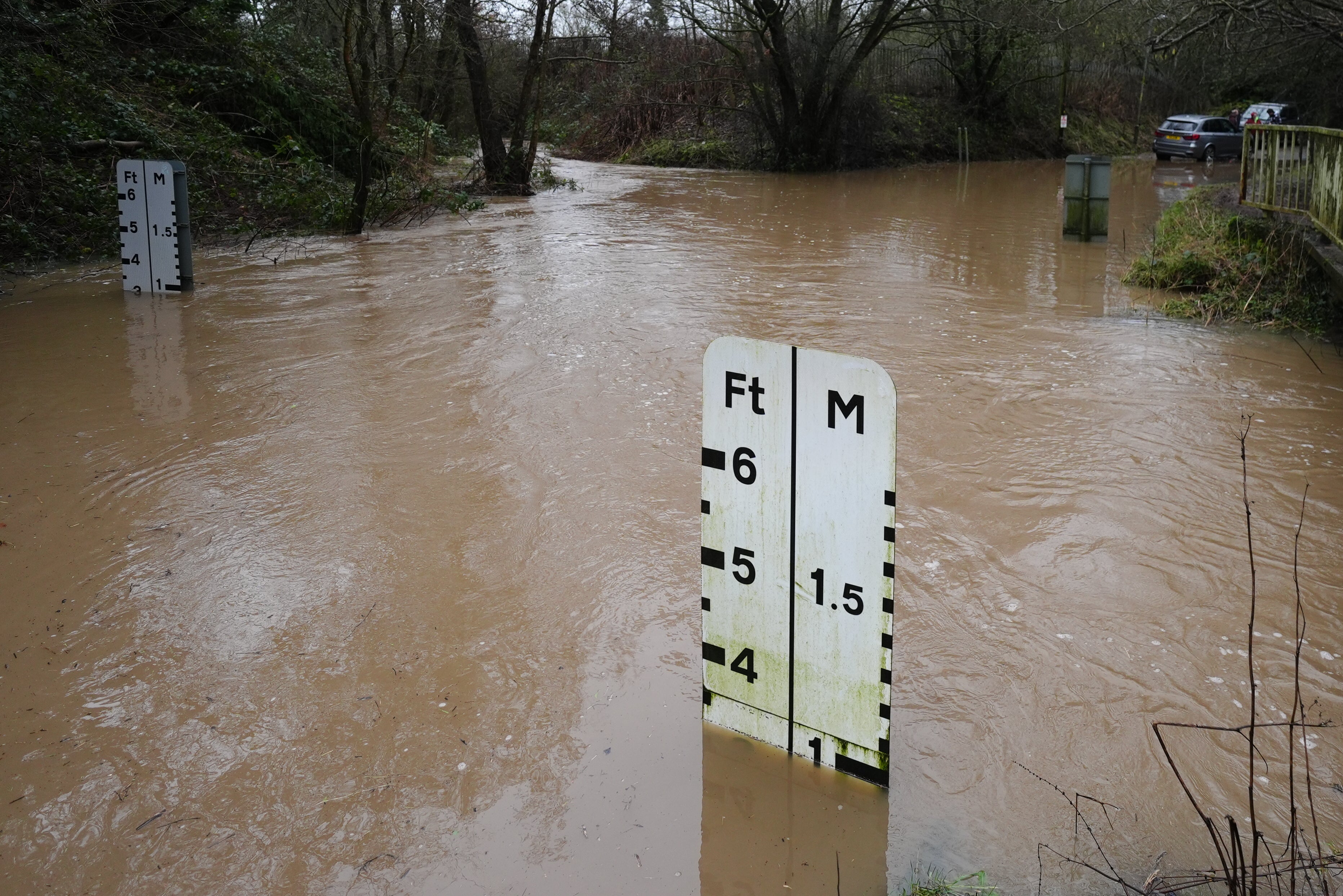
River Otter reaches record level of 2.83m due to floodwater
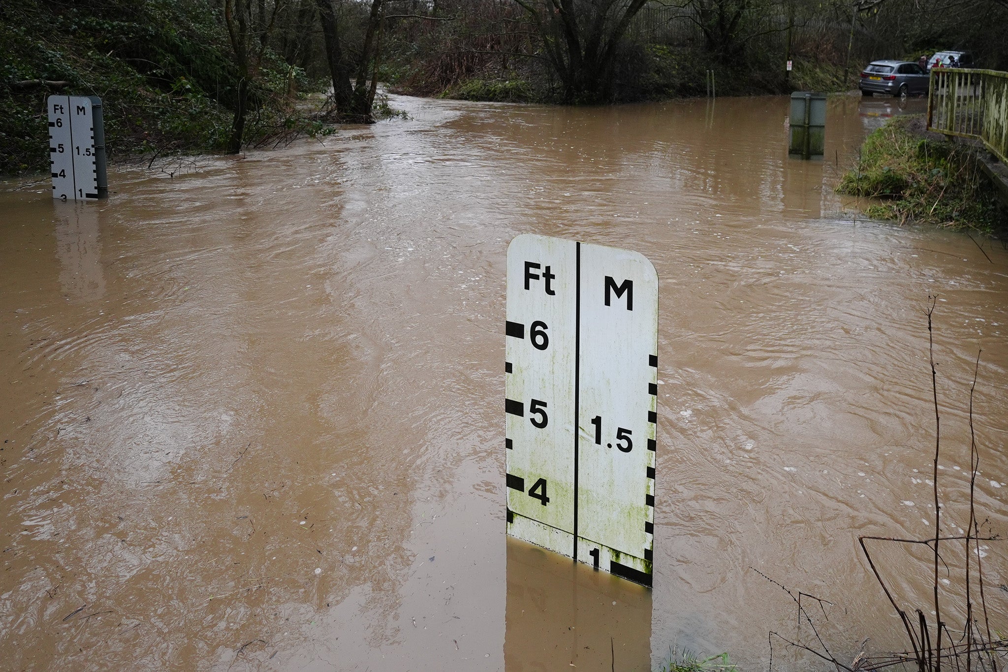
Wednesday 28 January 2026 02:00 , Shaheena UddinThe Environment Agency said the River Otter at Fenny Bridges, close to Ottery St Mary, has reached its highest recorded level, surpassing the previous record set in December 2000.
Levels reached 2.81m on December 7 that year but were at 2.83m at 5.45am on Tuesday, with a severe flood warning issued five minutes later due to predicted overtopping of flood defences.
A spokesman said: “Storm Chandra brought significant rainfall across Devon and Cornwall overnight, falling on already saturated ground.
“East Devon received 67mm of rain in the last 12 hours, with 88mm recorded at Whitebarrow on Dartmoor. Across south and mid Devon, rainfall averaged 40-50mm.
“There are currently 33 flood alerts and 39 flood warnings in force across Devon and Cornwall. Approximately 20 properties have flooded at various locations, with this number expected to rise.”
Drivers urged to carry floodkits due to heavy rain
Wednesday 28 January 2026 01:00 , Shaheena UddinThe Met Office have warned drivers and residents in affected areas to prepare a floodkit, to help in the event that their home, business or car becomes damaged.
It is not safe to drive or walk or swim through floodwater, avoid it where possible and if you are affected by fast flowing or deep water call 999 and wait for help.
Preparing a floodkit should include:
- Insurance documents and list of contact numbers
- Torch & spare batteries
- First aid kit and any prescription medicines
- Warm waterproof clothes and blankets
- Bottled water and snacks
- Battery or wind-up radio
- Supplies for looking after your baby or pet
Recap: Woman hospitalised after tree falls on car in Co Fermanagh
Wednesday 28 January 2026 00:00 , Shaheena UddinA woman was taken to hospital after a tree fell on a car in the Snowhill Road area, Lisbellaw.
The Northern Ireland Ambulance Service said it received a 999 call shortly after 8am on Tuesday, following reports of an RTC.
The PSNI have said her injuries are not believed to be serious. A spokesperson added: "NIAS tasked one Emergency Ambulance to the scene.
"Following assessment and initial treatment at the scene, 1 person was taken to South West Acute Hospital, by Ambulance."
The PSNI said the Snowhill Road in Enniskillen is blocked by fallen trees.
A spokesperson said: "A woman was taken to hospital after a tree fell on a car on Snowhill Road, Lisbellaw at around 8.30am this morning.
"At this time her injuries are not believed to be serious. The Snowhill Road remains blocked by fallen trees and should be avoided by motorists at present."
Storm Chandra impact hits airports and flights
Tuesday 27 January 2026 23:00 , Shaheena UddinThe Independent’s travel correspondent Simon Calder reports:
Storm Chandra is continuing to sweep across the UK, causing significant disruption to flights.
The worst-hit airport is Belfast City, which is in the middle of the area affected by the Met Office amber warning for high winds. At least 27 flights across the Irish Sea to Great Britain have been grounded: 18 Aer Lingus Regional links to a range of British airports, as well as nine British Airways arrivals and departures serving London.
The Scottish airline Loganair has grounded 20 flights, including links from:
- Manchester to Newquay
- London Heathrow, Manchester and Liverpool to the Isle of Man
- Glasgow to Barra, Campbeltown, Islay and Tiree
Under air passengers’ rights rules, travellers whose flights are cancelled are entitled to be flown to their destination as soon as possible on any airline, and to be provided with meals and hotels until they get there.
Watch: BBC presenter calls out weather man after he forgets Storm Chandra name
Tuesday 27 January 2026 22:00 , Shaheena UddinA 'major incident' of flooding declared in Somerset
Tuesday 27 January 2026 21:15 , Shaheena UddinA “major incident” of flooding was declared in Somerset, as agencies ramp up their response to Storm Chandra.
Somerset Council, the Environment Agency and emergency services have been working closely to aid communities affected by heavy rain and extensive flooding overnight.
The major incident has been declared as a precautionary measure to allow resources to be distributed, should the response need to be escalated.
Although the weather is forecasted to be drier tomorrow, the risk of flooding on the Levels and Moors is still high as rainwater moves through the system. Further flood warnings are expected to be issued in areas such as Moorland.
Met Office shares 4 tips for staying safe in ice
Tuesday 27 January 2026 21:00 , Shaheena UddinWhen there is an ice warning in place, the Met Office have shared some advice on things to be aware of...
1. What if you need to drive somewhere?
Icy, wintry weather can cause delays and make driving conditions dangerous, follow these few simple steps to prepare before journeys:
- Plan your route.
- Check for delays and road closures.
- Leave more time to prepare and check your car before setting off.
- Check wipers, tyres and screen wash.
- Pack essentials in your car (warm clothing, food, drink, blanket, torch).
- Take a fully charged mobile phone
- Pack an in-car charger.
2. How to drive safely on ice
It is safer not to drive in icy conditions, but if you absolutely must drive, keep yourself and others safe by:
- Looking well ahead for potential hazards and keep your speed down.
- Accelerating, braking, steering and changing gear as smoothly as possible to reduce the risk of a skid.
- Using a higher gear may be more appropriate to help grip on packed ice.
- Using a higher gear helps manage engine power making it easier to find traction.
3. What if you’re walking or cycling?
- Plan to leave the house five minutes earlier than normal. Not needing to rush reduces your risk of accidents, slips and falls.
- If making a journey on foot, try to use pavements along main roads which are likely to be less slippery. Similarly, if cycling, try and stick to main roads which are more likely to have been treated.
- Take extra care when walking on untreated pavements and prepare for journeys by wearing footwear with a good grip.
- Where possible do not cycle on untreated roads as accidents are more likely.
4. Look out for elderly relatives or neighbours
During icy and cold weather there are some simple ways you can support elderly relatives or neighbours:
- Check to see if they need any practical help and that they are well.
- Make sure they have enough food supplies in case they cannot go out.
- Offer to clear their paths when you clear yours and spread salt. You can use ordinary table or dishwasher salt - a tablespoon for each square metre you clear.
In pictures: Heavy rainfall brings widespread flooding
Tuesday 27 January 2026 20:30 , Shaheena Uddin
‘Further disruption possible’ after Storm Chandra causes flooding and power cuts
Tuesday 27 January 2026 20:00 , Shaheena UddinForecasters have warned of possible further disruption as Storm Chandra continues to batter Ireland on Tuesday evening.
Wind and rain warnings are in place for Northern Ireland until midnight on Tuesday, while a nationwide wind warning is in effect in the Republic, along with a rain warning for south-eastern counties, until 11pm.
Hundreds of schools were shut and tens of thousands of people were left without power after the storm swept across the island of Ireland.
The poor weather is likely to continue into Wednesday morning, with the Met Office issuing a yellow-level ice warning for all of Northern Ireland between 3am and 10am.
In the Republic of Ireland, ESB said around 20,000 homes, farms and businesses lost power due to the storm.
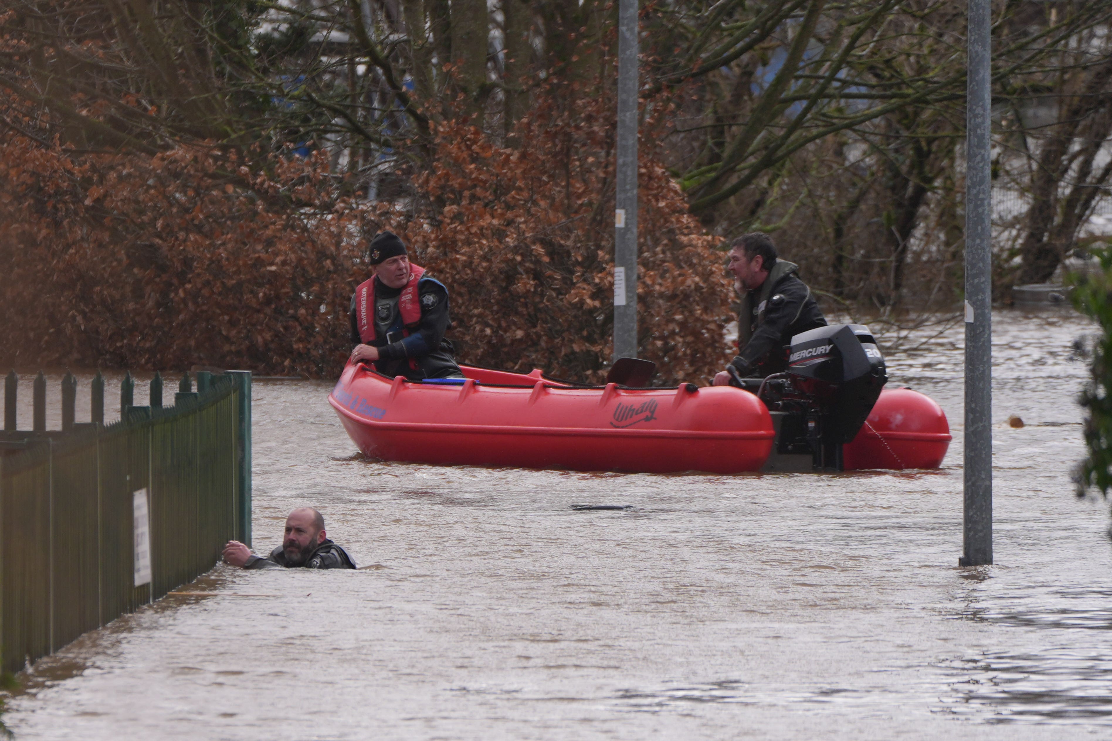
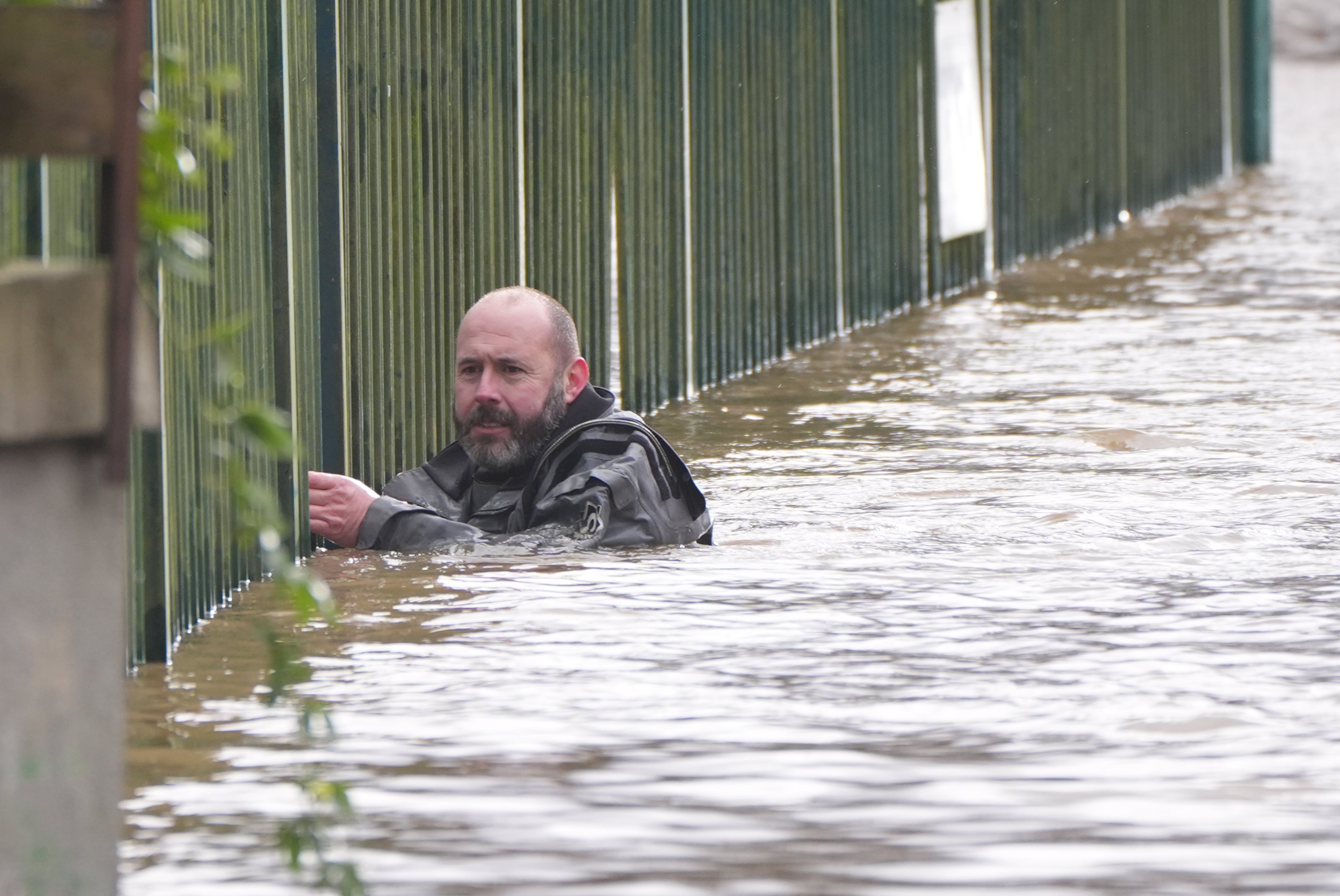
In pictures: Search and Rescue team wading through floodwater to save people
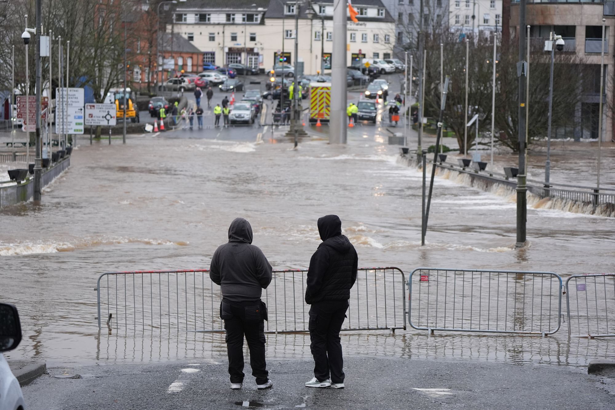
Tuesday 27 January 2026 19:44 , Shaheena UddinEnniscorthy in Co Wexford was particularly severely hit on Tuesday after the river Slaney burst its banks – marking the sixteenth time the town has flooded since 2001.
Grandmother Elaine Grant described how she, her daughter Casey and her three-week-old grandson were rescued from an apartment in Enniscorthy after it flooded.
Slaney Search and Rescue brought along an empty boat to the apartment block so they could bring along items for the newborn.
“(The baby) slept the whole way through,” she told RTE Radio, as she called for Government measures for the flood-prone town.
The Government announced an Emergency Response Payment to provide support to people living in properties in Co Wexford.
Dublin Fire Brigade said it had responded to a number of flooding incidents in the capital, after the River Dodder burst its banks, while in Dundalk, firefighters rescued two crew members of an ambulance which was stuck in floodwater under the Castletown Road railway bridge at around 6am.
88 flood warnings were issued today
Tuesday 27 January 2026 19:30 , Shaheena UddinThe Environment Agency issued 88 flood warnings on Tuesday for areas where flooding was expected.
The government organisation also issued 251 flood alerts for regions where flooding was possible.
In the last 24 hours 93 flood warnings were removed.
Local flooding is also possible more widely from rivers in parts of England from Wednesday to Friday. Land, roads and some properties may flood and there may be travel disruption.
On Thursday local flooding is possible but not expected from surface water and rivers in parts of England. Properties may flood and there may be travel disruption.
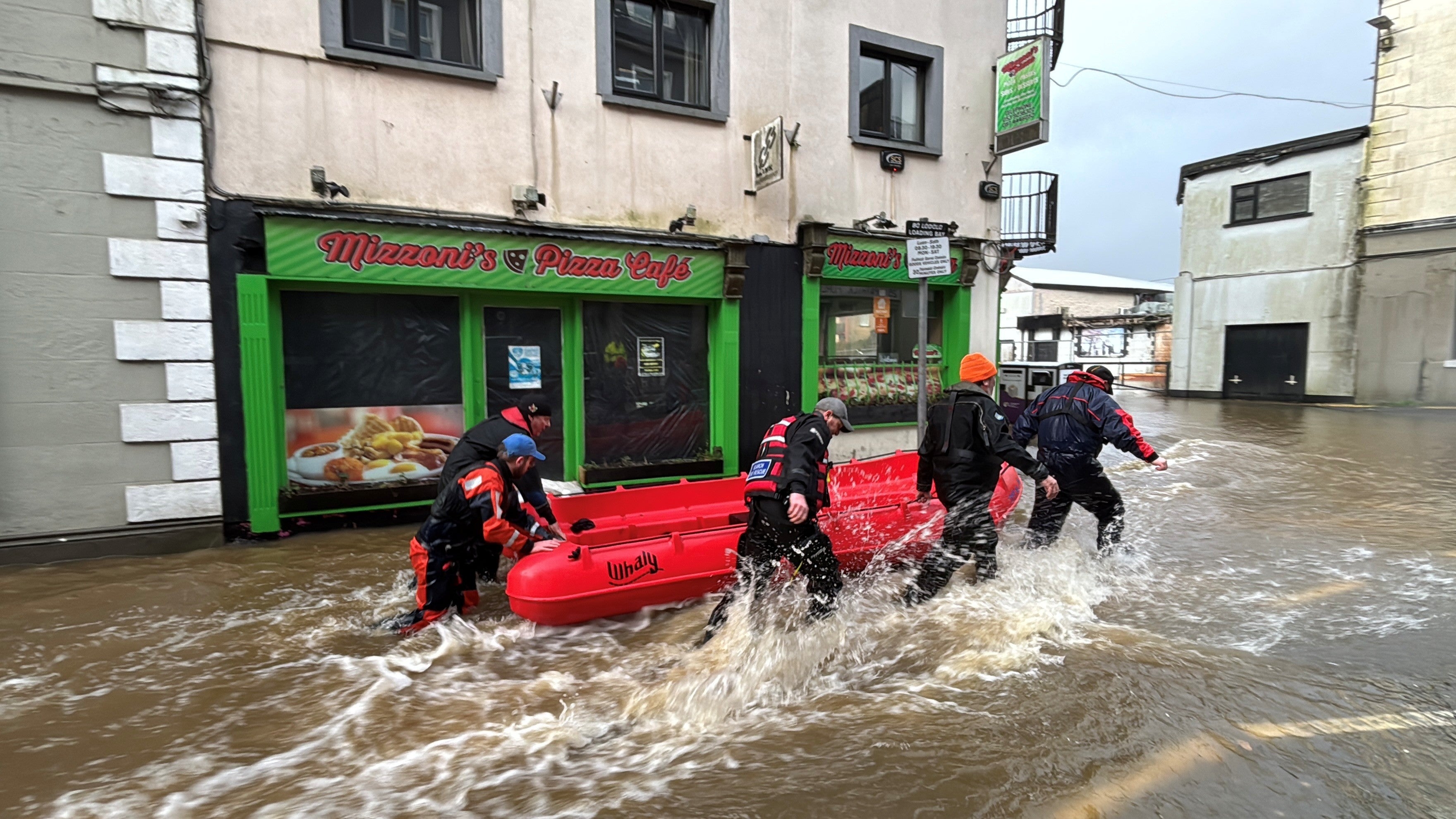
In pictures: Severe flooding across the UK and Ireland
Tuesday 27 January 2026 19:00 , Shaheena Uddin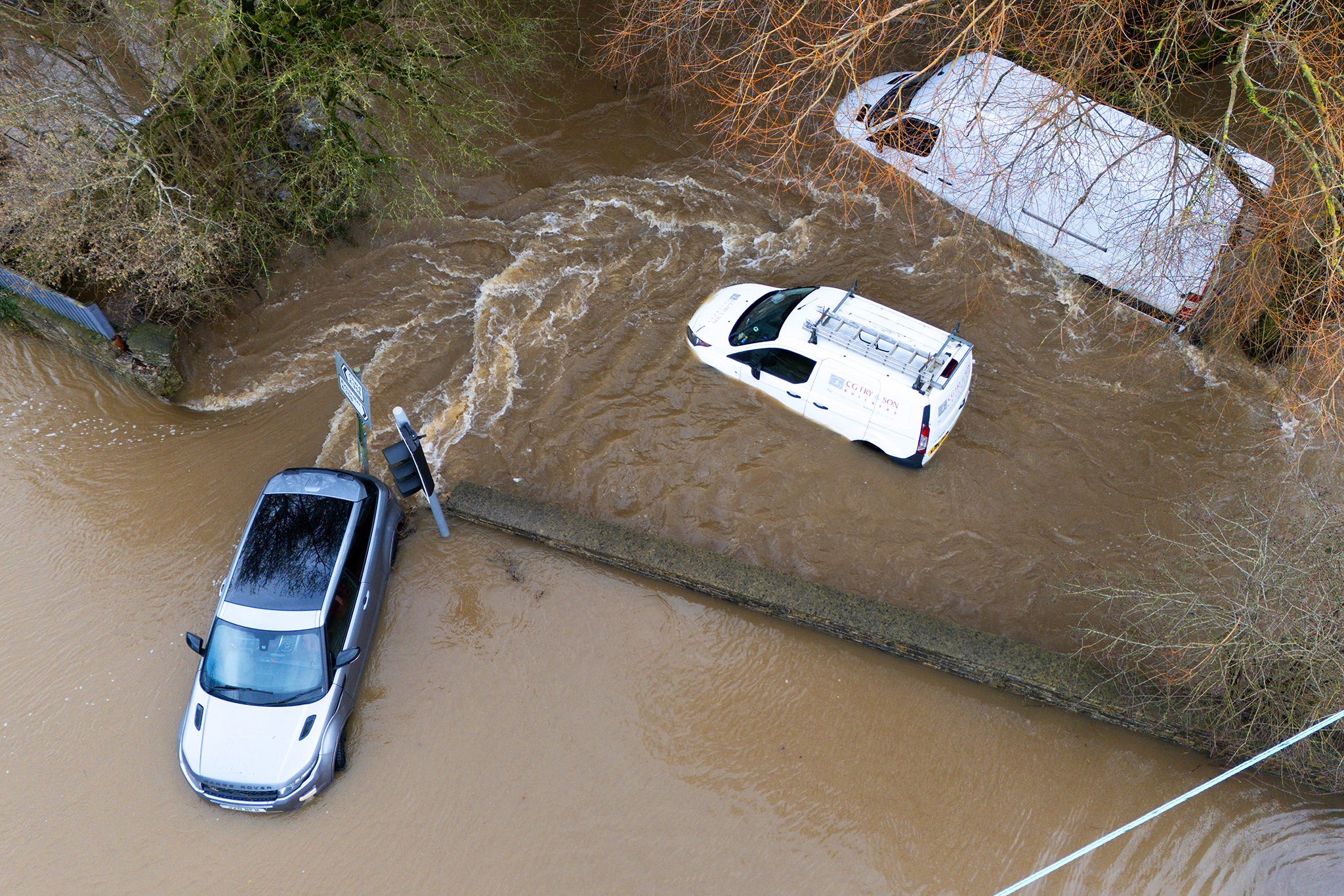
How to prepare a winter kit for car
Tuesday 27 January 2026 18:30 , Shaheena UddinIt's worth packing a few necessities in your car's boot to make sure you're prepared in case of getting stuck in cold and wintry weather.
RAC experts have shared the following advice on what to put in your car winter kit:
- Ice scraper and de-icer
- A large torch with spare batteries or a wind-up torch
- Paper road atlas
- In-car phone charge
- Warm clothes and blankets
- High-visibility clothing
- Jump leads
- Empty fuel can
- Food and drink
- Shovel
- Warning triangles
- Sunglasses
What rights do you have to compensation for cancelled or delayed flights?
Tuesday 27 January 2026 18:00 , Shaheena UddinAs passengers face delayed or cancelled flights on Tuesday due to Storm Chandra, The Independent’s travel correspondent Simon Calder takes a look at what rights you have to compensation.
You can read his analysis below:

Can you get a refund for cancelled or delayed flights? Your rights explained
Latest radar of rain and showers this evening
Tuesday 27 January 2026 17:45 , Shaheena UddinTake a look at where the rain and showers are this evening in the latest radar📡 pic.twitter.com/yM0n2o74xY
— Met Office (@metoffice) January 27, 2026
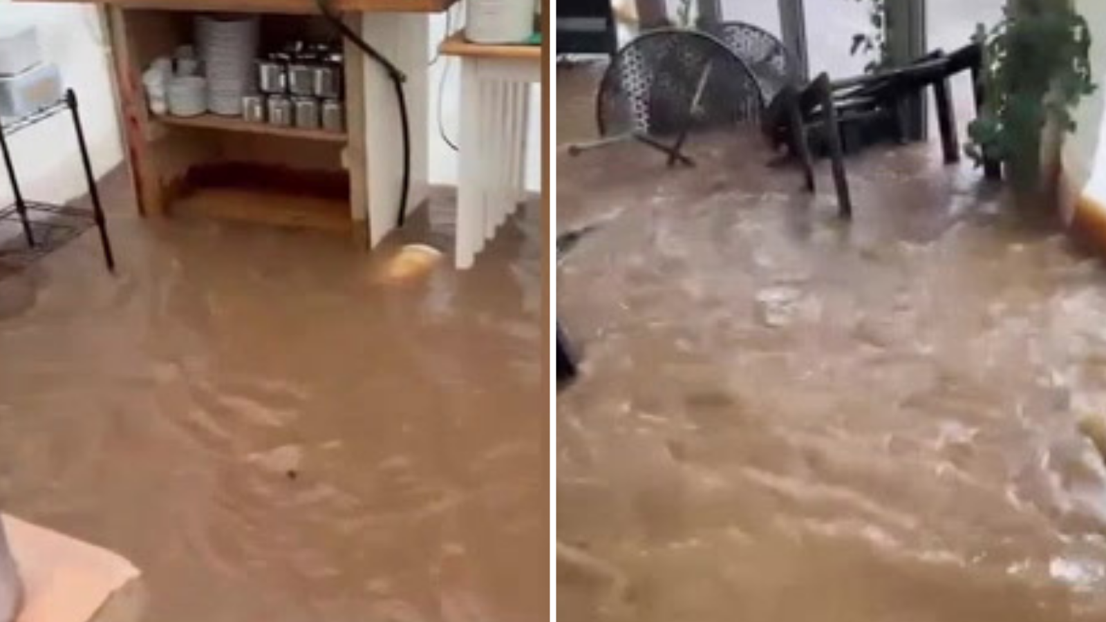
Watch: Otterton Mill devastated by Storm Chandra flooding
Tuesday 27 January 2026 17:30 , Shaheena UddinWhat is the forecast like for the rest of this week?
Tuesday 27 January 2026 17:15 , Shaheena UddinStorm Chandra is expected to clear with possible icy stretches predicted overnight, according to the Met Office.
This Evening and Tonight:
Rain and hill snow is likely to clear to the north, and the weather will turn drier for many, with just a few showers in the south.
The forecasters predict it to be windy in the north at first, but winds will gradually ease. It is likely to feel cold with a few icy stretches on untreated surfaces.
Wednesday:
There are two yellow warning issued for ice in parts of Northern Ireland and another affecting central England, the East Midlands, the east of England, London and South East England, North East England, North West England, Scotland and Lothian borders, Strathclyde, Wales, West Midlands, and Yorkshire and Humber.
Forecasters expect patchy fog in the east at first. They predict there to be outbreaks of showery rain in the southwest and northeast, but it will otherwise be dry for many with some sunny spells. Breezy, but generally less windy.
Outlook for Thursday to Saturday:
Staying unsettled with further showers or longer spells of rain, particularly in the southwest and eastern Scotland. Some drier interludes too, particularly in the east. Feeling chilly in brisk winds
Local flooding is possible but not expected from surface water and rivers in parts of England on Thursday. Properties may flood and there may be travel disruption, according the Environment Agency in England.
Rain and hill snow predicted to move into the far northeast of Scotland this evening
Tuesday 27 January 2026 17:00 , Shaheena Uddin#StormChandra continues to move northwards this evening with rain and hill snow moving into the far northeast of Scotland ⚠️
— Met Office (@metoffice) January 27, 2026
Heavy showers in parts of Northern Ireland and southwest England & Wales 🌧️
Otherwise, turning colder with clear skies and easing winds 🥶 pic.twitter.com/U6dFJfmf5S
Met Office issues travel advice for driving in storms, rain and strong wind
Tuesday 27 January 2026 16:45 , Shaheena UddinThe Met Office have issued travel advice for the following weather conditions:
Rain and flooded roads:
- If heavy downpours are expected, avoid starting your journey until it clears.
- If you can, choose main roads, where you are less likely to be exposed to fallen branches and debris and flooding.
- Roads will be more slippery than usual in wet weather – be sure to give yourself more time to react when approaching a hazard. Increase your following gap to at least four seconds from the moving traffic in front.
- If the road is flooded, turn around and find another route. The number one cause of death during flooding is driving through flood water, so the safest advice is turn around, don’t drown.
- Although the water may seem shallow, just 12 inches (30cm) of moving water can float your car, potentially taking it to deeper water from which you may need rescuing.
- Flood water also contains hidden hazards which can damage your car, and just an egg-cupful of water sucked into your car’s engine will lead to severe damage.
- Never drive through flood water. Turn around.
Low visibility:
- Use dipped headlights if visibility is seriously reduced.
- Even moderate rain can reduce your ability to see and be seen. A good rule of thumb is ‘if it’s time for your wipers, it’s time to slow down’.
- Keep your eyes peeled on the road at all times as spray from other vehicles can suddenly reduce your visibility. Remember it affects others too, so anticipate their actions and be prepared.
Strong winds:
- Gusts of wind can unsettle vehicles – grip your steering wheel firmly with both hands. This is particularly important when planning to overtake.
- Keep an eye out for gaps between trees, buildings or bridges over a river or railway – these are some of the places you are more likely to be exposed to side winds.
- Ensure that you maintain enough room either side of your vehicle so you can account for it being blown sideways.
- Remember to give vulnerable road users including cyclists, motorcyclists and pedestrians more room than usual. They are more likely to be blown around by side winds – always keep a safe distance.
In pictures: Storm Chandra floods roads in Ireland
Tuesday 27 January 2026 16:30 , Shaheena Uddin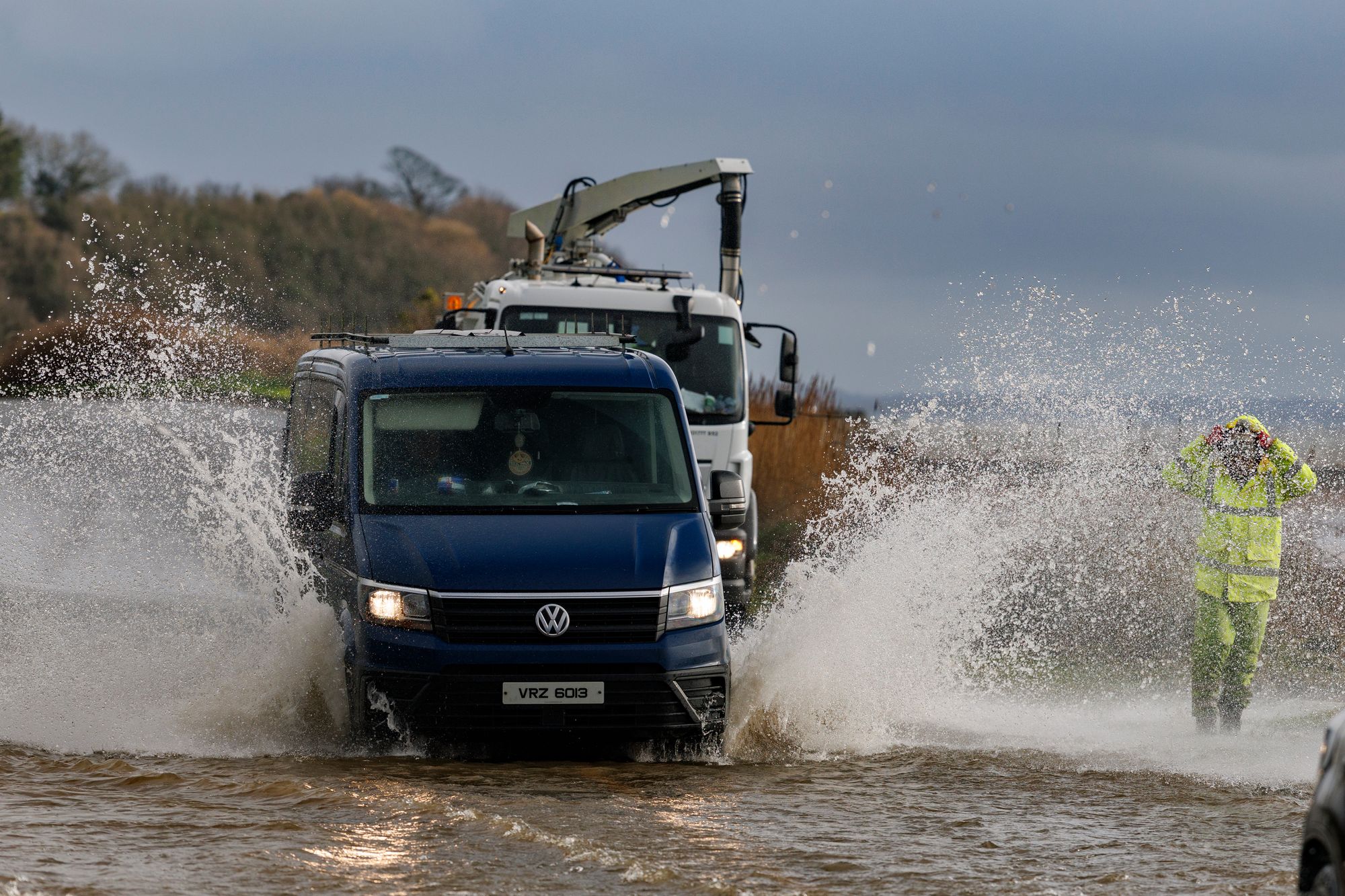
Storm Chandra triggers travel chaos across railways, roads, flights and ferries
Tuesday 27 January 2026 16:15 , Shaheena UddinTravel chaos has returned as Storm Chandra sweeps across many parts of the UK. Dozens of flights and ferry sailings have been cancelled, and several rail lines blocked.
The Independent’s Travel correspondent, Simon Calder, reports:

Storm Chandra triggers travel chaos across railways, roads, flights and ferries
Watch: Dozens of flights cancelled and thousands without power as UK hit by ‘horrendous’ flooding
Tuesday 27 January 2026 16:00 , Shaheena UddinSchools shut and thousands experiencing power cuts in Ireland
Tuesday 27 January 2026 15:45 , Shaheena UddinStorm Chandra has battered the island of Ireland, causing hundreds of schools to close and leaving tens of thousands of people without power.
Torrential rain has caused travel disruptions and flooded roads. Strong winds have also knocked down several trees across the nation.
The public have been warned of danger to life from flying debris, large waves at coasts, travel disruption, buildings damage, flooding, fallen trees, and possible power cuts.
In Northern Ireland, more than 300 schools have been closed.
There is a yellow rainfall alert currently in place for all six counties.
There is an amber warning for wind until 9pm in Antrim, Down and Derry, and the yellow rain warning is in effect until midnight.
Northern Ireland Electricity said the number of households without power peaked at 9am when 10,000 properties were without supply.
In the Republic of Ireland, ESB said around 20,000 homes, farms and businesses lost power as a result of the storm.
Translink has warned that passengers should allow for delays and possible disruption to their journey.
Strangford Lough Ferry Service is currently cancelled, the crew is onsite and will resume service when it is considered safe.
Summary of the latest yellow and amber weather warnings
Tuesday 27 January 2026 15:30 , Shaheena UddinThe Met Office has issued several yellow and amber warnings for rain, snow and wind this week.
Want a quick summary of the latest warnings? Look below 👇
— Met Office (@metoffice) January 27, 2026
Want more details? Look here 👉 https://t.co/QwDLMfRBfs
Stay #WeatherAware⚠️ pic.twitter.com/ikzqsc1GdP
Katesbridge has its wettest day on record
Tuesday 27 January 2026 15:15 , Shaheena UddinSeveral sites have provisionally set new January daily rainfall records, according to the Met Office.
Katesbridge has provisionally recorded its wettest day on record with over 100 mm of rainfall recorded.
Plymouth (Mountbatten) also saw a notable record of 43.2 mm at a site with over 100 years of observations.
Other records include: Hurn with 44.4mm, Dunkeswell Aeordrome with 52.8 mm, Cardinham, Bodmin with 44.4 mm and Shobdon Airfield with 27.8 mm.
In pictures: Heavy rainfall brings widespread flooding
Tuesday 27 January 2026 15:05 , Holly EvansBelfast university closes due to weather conditions
Tuesday 27 January 2026 14:55 , Holly EvansQueen's University Belfast has closed its campus today due to the amber weather warning.
In a post on social media, the university said that safety and wellbeing of students was the “top priority” and that teaching had been moved online.
Student support services remain available remotely while the McClay Library is due to reopen at 9pm this evening.
Your safety and wellbeing are our top priority. That's why the University campus will be closed tomorrow, Tuesday 27 January, due to the amber weather warning across Northern Ireland.
— Queen's University Belfast 🎓 (@QUBelfast) January 26, 2026
Where appropriate and possible, teaching will move online for our students and your School or… pic.twitter.com/GuTNsHOlI7
Woman hospitalised after tree falls on car in Co Fermanagh
Tuesday 27 January 2026 14:43 , Holly EvansA woman has been taken to hospital after a tree fell on a car in the Snowhill Road area, Lisbellaw.
The Northern Ireland Ambulance Service said it received a 999 call shortly after 8am on Tuesday, following reports of an RTC.
The PSNI have said her injuries are not believed to be serious. A spokesperson added: "NIAS tasked one Emergency Ambulance to the scene.
"Following assessment and initial treatment at the scene, 1 person was taken to South West Acute Hospital, by Ambulance."
The PSNI said the Snowhill Road in Enniskillen is blocked by fallen trees.
A spokesperson said: "A woman was taken to hospital after a tree fell on a car on Snowhill Road, Lisbellaw at around 8.30am this morning.
"At this time her injuries are not believed to be serious. The Snowhill Road remains blocked by fallen trees and should be avoided by motorists at present."