Satellites have seen smoke from Canadian wildfires gathering over the midwestern United States just days after space-based imagery spotted smoke creeping across the Atlantic into Europe.
The gathering smoke over the Midwest comes from fires that have been burning in the Canadian province of Quebec for weeks. It was spotted from orbit by the Geostationary Operational Environmental Satellite East (GOES-East) satellite, also known as GOES-16, operated by the U.S. National Oceanic and Atmospheric Administration (NOAA).
The Cooperative Institute for Meteorological Satellite Studies at the University of Wisconsin-Madison (UW-Madison CIMSS) shared the images on its Twitter feed Thursday (June 29), also showing fog that the smoke will help to perpetuate.
Related: Satellite photos show US East Coast engulfed by smoke from Canadian wildfires
#GOESEast reveals extensive wildfire #smoke and a large network of valley fog plus a few thunderstorms in the northeast U.S. this morning. The smoke, which extends south over Georgia and the Carolinas, will help keep much of the fog around. Find out at https://t.co/wkVtVDAbwc pic.twitter.com/h8EXNpNm4XJune 29, 2023
"GOESEast reveals extensive wildfire smoke and a large network of valley fog plus a few thunderstorms in the northeast U.S. this morning. The smoke, which extends south over Georgia and the Carolinas, will help keep much of the fog around," UW-Madison CIMSS wrote.
The smoke from the wildfires has pushed hundreds of miles into the U.S. and is causing a drop in air quality in areas from the mid-Atlantic to the Northeast and parts of the Upper Great Lakes to "unhealthy" and even "very unhealthy" levels on the U.S. Air Quality Index (AQI), according to AirNow.
According to the AQI, which was established by the U.S. Environmental Protection Agency (EPA), the unhealthy or "red" air quality level is defined as posing the risk that some people may experience health effects, with members of sensitive groups potentially experiencing more serious ones. The very unhealthy or "purple" level constitutes a health alert, with the risks of adverse health effects for everyone.
Unhealthy levels of smoke are expected for a wide swath of the Midwest today. Smoke from wildfires in Canada is impacting the area.If you have to be outside, take breaks indoors and consider using an N-95 mask to help reduce the smoke you breathe in.https://t.co/CVx9g8Hm1q pic.twitter.com/ewig73ubQ7June 28, 2023
Sharing a near-surface smoke concentration forecast for noon on Thursday on its Twitter feed, the U.S. National Weather Service (NWS) emphasized that precautions should be taken to mitigate potential adverse health effects.
The NWS wrote: "Unhealthy levels of smoke are expected for a wide swath of the Midwest today. Smoke from wildfires in Canada is impacting the area. If you have to be outside, take breaks indoors and consider using an N-95 mask to help reduce the smoke you breathe in."
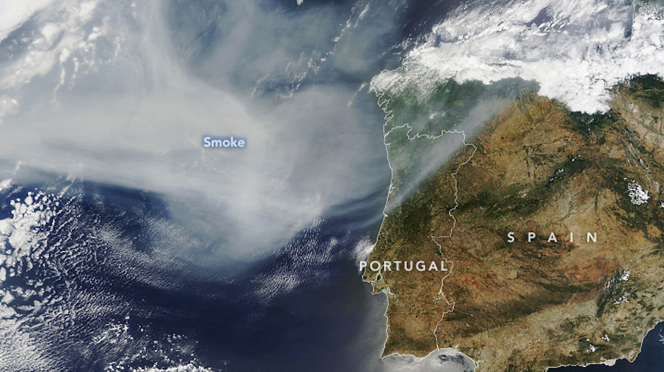
On Monday (June 26), the NASA Earth Observatory revealed an image collected by the Moderate Resolution Imaging Spectroradiometer (MODIS) instrument on NASA's Terra satellite of smoke drifting over the Atlantic, darkening skies over Spain and northern Portugal.
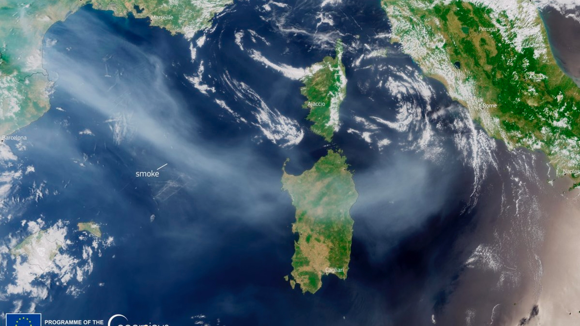
Canadian wildfire smoke has also reached other European countries. On Thursday morning, the Twitter account of Copernicus EU — the Earth-observation component of the European Union Space Program — shared an image taken by the Sentinel 3 satellite on Wednesday (June 28) that showed smoke reaching the Italian island of Sardinia.
Because the smoke is higher in the atmosphere over the European countries affected, people in those countries are unlikely to experience the same hazardous conditions arising in Canada and the U.S.