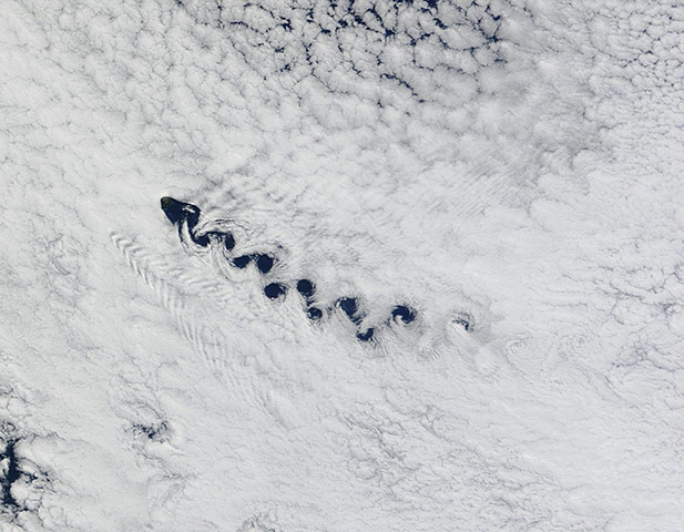
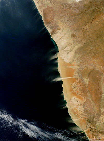
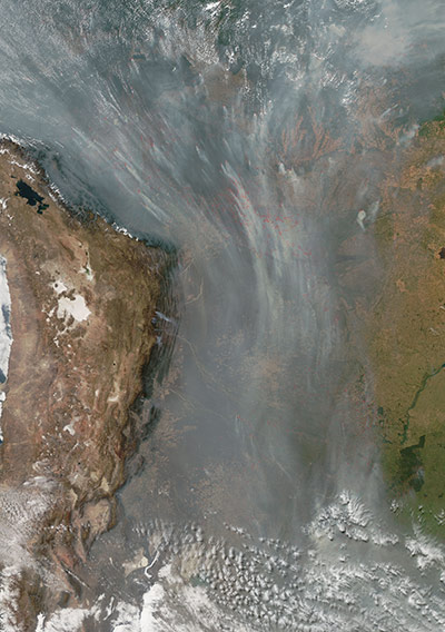
Creating a striking design which looks a bit like a serpent swimming through clouds, curling patterns of eddies are formed as air flows around and over the island of Tristan de Cunha in the South Atlantic. These spiraling cloud patterns, caused when prevailing ocean winds encounter an island, are known as von Karman vortices or 'vortex streets'. Home to about 275 people, Tristan de Cunha is considered to be the most remote inhabited island in the world, lying 2,816km (1,750 miles) from South Africa, the nearest land, and 3,360km from South AmericaPhotograph: Terra/MODIS/NASACloudless skies allow a clear view of dust and hydrogen sulfide plumes along the coast of Namibia. Multiple dust plumes blow off the coast toward the ocean, most or all of them probably arising from streambedsPhotograph: Terra/MODIS/NASAAqua satellite detected 148,946 fires in this image on August 23, 2010. The fires are outlined in red. Most of the fires are concentrated in Bolivia, where the governments of two states had declared a state of emergency because of widespread fires three days earlier. Scores of fires also burn in Brazil, Paraguay, and Argentina. While some fires do occur naturally in Bolivia, most of these fires were probably set deliberately to clear land for crops or pasturePhotograph: Aqua/MODIS/NASA
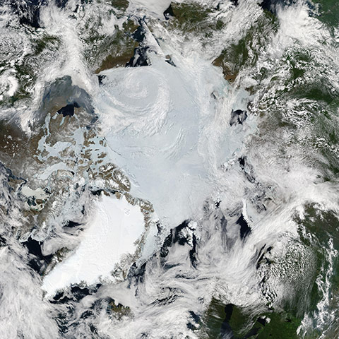
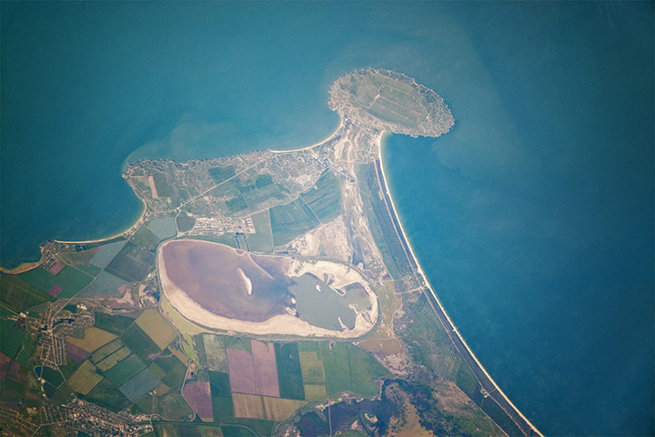
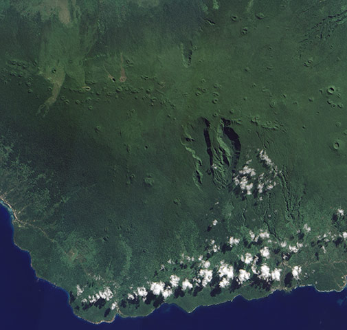
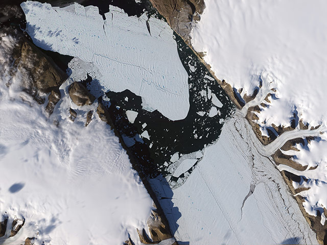
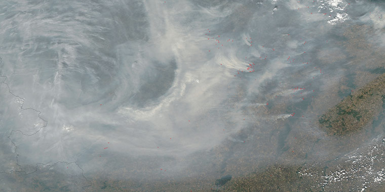
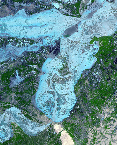
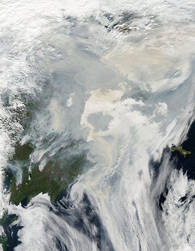
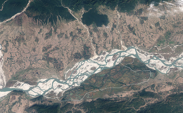
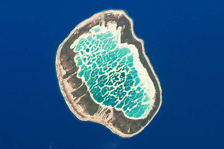
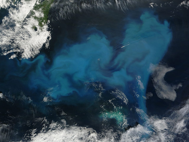
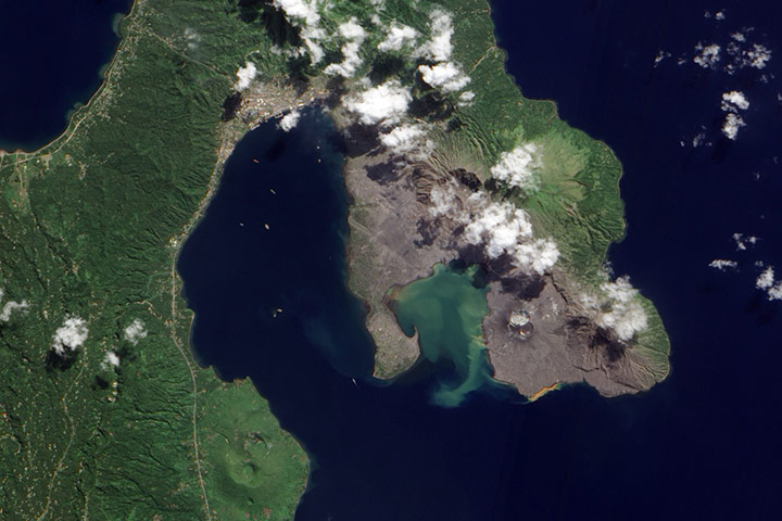
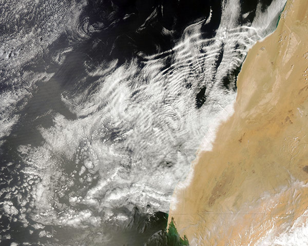
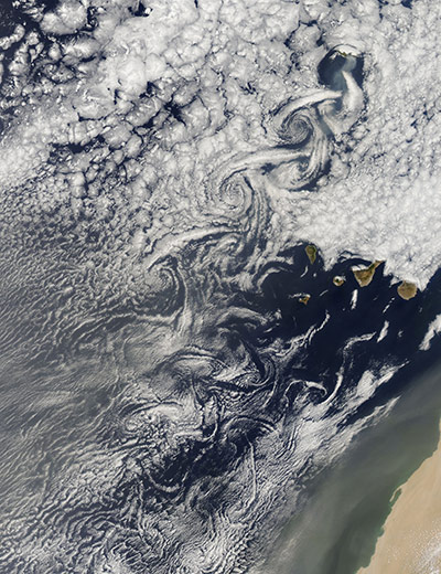
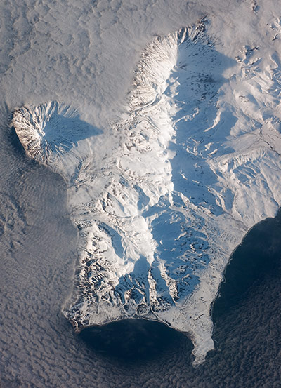
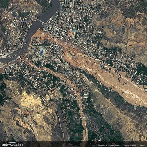
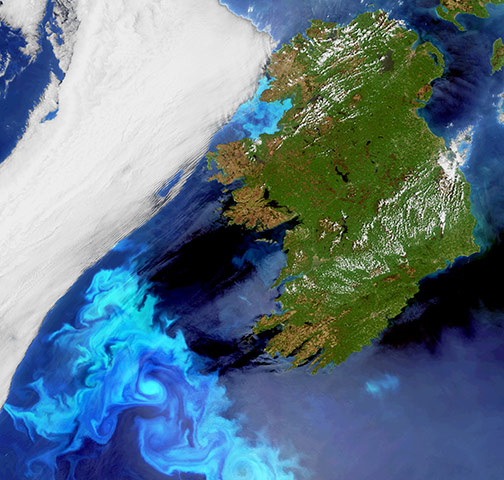
Clear skies in late June 2010 allow sunlight to melt snow and ice in the Arctic. The conditions mean unfiltered sunlight can reach the Arctic’s land and sea surfaces at a time of near round-the-clock daylightPhotograph: Aqua/MODIS/NASACape Kazantip is a prominent headland on the Kerch Peninsula, which defines the southern shore of the Sea of Azov and the east extension of the Crimean Peninsula. It has been the warm holidaying destination for generations of Ukrainians and Russians. Green and brown fields show intensive agricultural activity in the area, and salt ponds are visible at the west end of the shallow Lake Aktashskoye at the centre of the imagePhotograph: ISS/NASAHurricane Danielle churns in the Atlantic Ocean on 23 August, 2010. Winds reached speeds of 100mph (160kph)Photograph: NASAAt the western end of the Samoan Island chain lies Savai'i. Stretching more than 649sq miles, Savai'i is one of the largest landmasses in Polynesia. The mountainous island is a shield volcano that reaches its highest altitude 6,095 feet near the center of the island. The region's tropical, humid climate sustains vegetation that carpets much of the islandPhotograph: NASADust blows eastward out of the Taklimakan desert, China. The tan-colored dust plume flutters like a giant scarf across hundreds of kilometers of arid landscape. Source points for the plume are not obvious in this image, but the dust likely arose in the desert's western reaches. The Taklimakan is the largest shifting-sand desert in the worldPhotograph: Aqua/MODIS/NASAThe ice island that calved off the Petermann Glacier in northwestern Greenland on 5 August, 2010, continues its slow migration down the fjord 11 days later on 16 August. Although slivers of ice have loosened around its edges, the ice island has largely retrained its original shape. The island, which has rotated counterclockwise since the calving, also retains the crevassed structure of the Petermann GlacierPhotograph: ALI/EO-1/NASAFires continue burning around Moscow on 7 August, 2010, prompting locals to stay indoors or venture out only with gauze masks. Red outlines indicate active fires, and multiple fires cluster east of Moscow, many of them sending their smoke over the city. Smoke almost completely hides the land surface throughout this scene. Carbon monoxide levels in the capital city were several times the maximum allowable limit. Meanwhile, firefighters fought 577 fires covering 193,516 hectares (747square miles)Photograph: NASACloud-free image over the city of Sukkur, Pakistan, captured on 18 August, 2010. Sukkur, a city of 500,000 residents located in southeastern Pakistan's Sindh Province, is visible as the grey, area in the lower left centre of the image. It lies along the Indus River, Pakistan's longest, which snakes vertically from north to south through the image and is the basis for the world's largest canal-based irrigation systemPhotograph: Terra/ASTER/NASAIntense fires continue to burn in the boreal forests of eastern Siberia on 1 August, 2010. The fires span the borders of Russia's Chukotskiy, Magadan, and Koryakskiy provinces. Burning in coniferous (evergreen) forests, the fires blanketed northeastern Siberia with thick brown smoke. The smoke hugs the ground near the fires, filling valleys, and soars over clouds farther away from the flames. On August 1, the smoke flowed north from the fires and over the Arctic Ocean. A wide view of the Arctic shows the smoke crossing the Bering Strait and clouding skies over northern AlaskaPhotograph: Aqua/MODIS/NASAIn the state of Assam, in the northeastern corner of India, Kaziranga National Park protects a few hundred square miles of the Brahmaputra River's natural floodplain. In the fertile soil washed down from the Himalaya Mountains during the yearly floods, lush grasses grow up to 20 feet high, making the park a paradise for grazing animals and their predators. The river flows west through braided channels interspersed with sandy islands. The grassy expanse of the park to the south is dotted with pools of waterPhotograph: NASAThe Tuamotu Archipelago is part of French Polynesia, and forms the largest chain of atolls in the world. This photo features Mataiva Atoll, the westernmost atoll of the Tuamotu chain. Mataiva Atoll is notable in that its central lagoon includes a network of ridges (white, image centre) and small basins formed from eroded coral reefs. Mataiva means 'nine eyes' in Tuamotuan, an allusion to nine narrow channels on the south-central portion of the island. The atoll is sparsely populated, with just a single village Pahua located on either side of the only pass providing constant connection between the shallow (light blue) water of the lagoon and the deeper (dark blue) adjacent Pacific Ocean. Much of the 10km-long atoll is covered with forest (greenish brown). Vanilla and copra (dried coconut) are major exports from the atoll, but tourism is becoming a larger part of the economyPhotograph: ISS/NASAPhytoplankton are microscopic organisms that live in watery environments. When conditions are right, they undergo explosive population growth, creating blooms visible from space. Such a bloom occurred in the North Atlantic Ocean, off the coast of Newfoundland on August 9, 2010. The paisley pattern of peacock blue owes its colour to phytoplankton. Phytoplankton thrive at high latitudes, especially in the spring and summer when abundant sunlight spurs photosynthesis, and relatively calm seas allow the tiny organisms to congregate in sunlit waters. Blooms can last for weeks even though an individual phytoplankton lifespan may be just a few daysPhotograph: Terra/MODIS/NASAVolcanic cones and settlements mingle along the margins of the Rabaul Caldera on the northeastern tip of Papua New Guinea's New Britain Island. Shaped like a giant cauldron, the caldera is the remaining rim of an ancient volcano. Small volcanic cones, some of which are still active, sit on the rim. Spanning roughly 8 by 14 kilometers (5 by 9 miles), the caldera is flooded by Blanche Bay. The largely submerged caldera long formed a natural harbour for what had been New Britain's largest city, but a major eruption forced the evacuation of Rabaul City in 1994Photograph: ALI/EO-1/NASARipple-like wave clouds dominate a complex pattern located over the Atlantic Ocean, off the coast of the western Sahara. A wave cloud is created by atmospheric standing waves. A moist atmosphere allows clouds to form at the crests of the otherwise invisible waves, but the clouds evaporate in the descending part of the waves. Here, a pattern of swirling vortices can be seen in several areas, including underneath the cloud waves. These are called von Karman vortices, and are formed as wind flow is interrupted by the Canary Islands, which lie to the north of imagePhotograph: Aqua/MODIS/NASAThe steady south, southwest flow of bright white clouds on the Portuguese trade winds is dramatically interrupted by the island of Maderia and by the Canary Islands, resulting in swirls and eddies on the leeward side of each island. In the northeast corner of the image, the island of Maderia, Portugal, rises 1,862 meters (6,109 feet) above the ocean surface. On the day this image was captured, large fires were burning on the island and a wide plume of gray smoke can be seen trailing from the islandPhotograph: Aqua/MODIS/NASAThe Kuril Island chain is built from a line of volcanoes, an island arc, that extends from Russia’s Kamchatka Peninsula to northern Japan. Arcs of volcanic islands form along an active boundary between two tectonic platesPhotograph: ISS/NASATucked between the steep slopes of the Min Shan and the Bailong River in northwest China, the city of Zhouqu has a picturesque location. But on 8 August, 2010, unusually intense monsoon rains triggered devastating landslides and floods that buried a densely populated area in the centre of the city. More than a thousand people died. This detailed image shows the largest slide in the lower part of the city on 10 August. The slide terminates in a brown fan that extends into the Bailong River. Mud surrounds several of the buildings near the river's edge and branches into adjacent streets Photograph: WorldView-2 satellite/DigitalGlobeElectric blue-coloured plankton blooms swirl in the North Atlantic ocean off Ireland. Plankton, the most abundant type of life found in the ocean, are microscopic marine plants that drift on or near the surface of the sea. While individually microscopic, the chlorophyll they use for photosynthesis collectively tints the surrounding ocean waters, providing a means of detecting these tiny organisms from space with dedicated 'ocean colour' sensorsPhotograph: Envisat/MERIS/ESASatellite view of EarthPhotograph: NOAA/Rex Features
Sign up to read this article
Read news from 100’s of titles, curated specifically for you.