While Tamil Nadu was recovering from the devastation caused by the tropical cyclone Michaung, another catastrophic event occurred on December 18, this time over the southernmost parts of the State. The southern districts of Tamil Nadu — Thoothukudi, Tirunelveli, Tenkasi and Kanyakumari — experienced unprecedented and extremely heavy rainfall on December 17 and December 18. At least nine rain gauge stations in these districts reported heavy rainfall of more than 50 cm. The Kayalpattinam station in Thoothukudi recorded 95 cm of rainfall in just 24 hours. In terms of probability, this event could be termed as a once in a hundred-year event. These heavy rains led to massive and widespread flooding, caused extensive damage, and claimed a few lives. Due to the heavy rainfall, many villages were under water and thousands of villagers were without food, drinking water and electricity for a couple of days. The heavy downpour was reminiscent of the heavy rains (94.4 cm) in Mumbai on July 26, 2005 in terms of the quantum of rainfall.
The cause
The 2023 northeast monsoon was in an active phase during this episode, characterised by the presence of an east-west trough (or ITCZ). The unprecedented heavy rainfall on December 18 was associated with an easterly wave with an embedded cyclonic circulation that moved from the southwestern Bay of Bengal across southern Tamil Nadu and Kerala into the southeastern Arabian Sea between December 16 and December 19. There was a large-scale, intense convergence of winds with the influx of abundant moisture into the region. Most of the recent rains fell in the early morning hours of December 18, supported by the climatological diurnal pattern over the region. The north-south running hills along the Tamil Nadu-Kerala border are also likely to have contributed to the dynamics of the heavy rains.
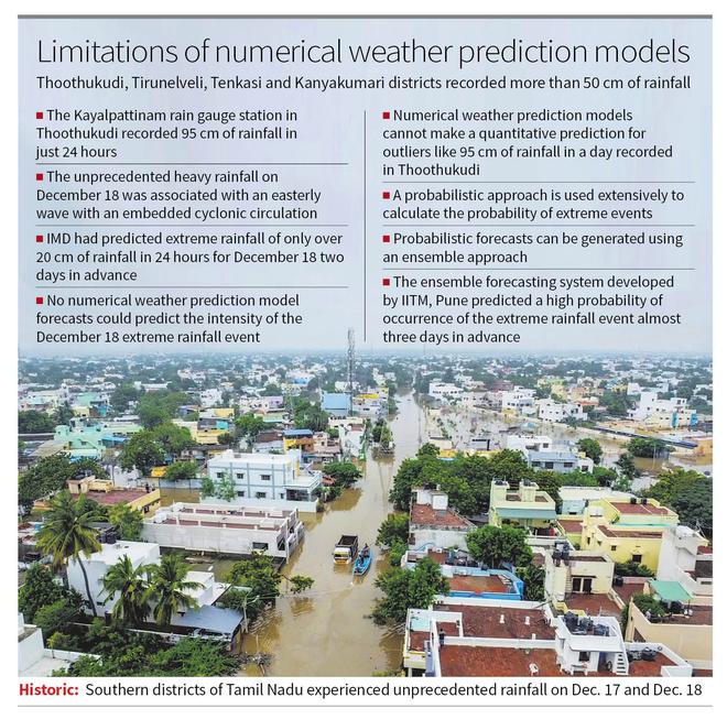
Was this rain event accurately predicted? The India Meteorological Department (IMD) had predicted extreme rainfall (more than 20 cm of rainfall in 24 hours) for December 18 about 48 hours in advance and issued a red level warning. But rainfall of more than 50 cm was not expected at all. Compared to a tropical cyclone, this weather system was a weaker system. A review of the available numerical weather prediction (NWP) model forecasts showed that no model could predict the intensity of this heavy rainfall event. The models only predicted heavy rainfall in the order of 20-25 cm in 24 hours. However, the numerical weather prediction models cannot make a quantitative prediction for this kind of outlier — 95 cm of rainfall.
Probabilistic forecast
For prediction of extremes, a probabilistic approach is generally used extensively to calculate the probability of such extreme events occurring in each region. These probabilistic forecasts can be generated using an ensemble approach, where we generate a larger number of forecasts (30-40 forecasts) with perturbed initial conditions. The Indian Institute of Tropical Meteorology (IITM) in Pune has developed such a prediction system for making probabilistic forecasts. This ensemble forecasting system was able to suggest the high probability of occurrence of extreme rainfall event in southern Tamil Nadu almost three days in advance. But the prediction did not indicate 95 cm rainfall in Thoothukudi. We should make more use of these probabilistic forecasts for extreme events instead of relying on quantitative predictions. Probabilistic forecasts provide more lead time, which can be used for better preparation. End users should be trained to use probabilistic methods for proper mitigation of such extreme events.
The fact that this event is once in a hundred-year event does not mean that it can happen only after 100 years. It could happen next year too. The IPCC models clearly indicate that extreme precipitation events may occur more frequently as global warming progresses. Heavy rainfall of this magnitude due to a relatively weak weather system should really worry us.
Multifaceted approach
In the face of increasing extreme rainfall events, it is imperative that we take a multifaceted and proactive approach to mitigate the impact and strengthen the resilience of our communities. To meet the challenge of climate change, a comprehensive strategy that includes robust early warning systems, sustainable urban planning, ecosystem conservation, global climate action and community engagement is essential to effectively mitigate the impacts of increasing extreme precipitation events. Robust early warning system is very vital, but it is only one component of this comprehensive strategy. More research is required for better understanding of the physical processes of these extreme events. Public awareness and education also play a crucial role in building resilience. Communities should be educated about the risks associated with extreme precipitation events and receive information on how to prepare and respond effectively. Taking proactive measures today will contribute to a more resilient and sustainable future for generations to come.
(Madhavan Nair Rajeevan was a former Secretary to the Government of India and presently the Vice Chancellor, Atria University, Bengaluru. Views expressed are personal)