Residents and holiday-makers in Western Australia's north have been put on alert as a potential severe tropical cyclone brews off the coast.
The tropical low is currently over waters north of the Kimberley, about 475 kilometres north of Broome as of early Tuesday morning.
It is expected to reach cyclone intensity during Tuesday, at which point it will be named Tropical Cyclone Ilsa.
Current forecast tracks from the Bureau of Meteorology (BOM) have the cyclone reaching category-four level by Wednesday as it swerves toward the Pilbara coast, although there is still uncertainty about its exact path.
"It's going to continue to move to the south-west, strengthening over the coming days … with a coastal crossing likely around the Eighty Mile Beach area later this week," senior meteorologist Jessica Lingard said.
"Obviously cyclones are their own fickle beast, so we will have to keep a very close eye on this system as it continues to move."
At a mid-afternoon briefing on Monday, the bureau's Todd Smith told reporters the cyclone was likely to make landfall late Thursday or early Friday between Port Hedland and Broome.
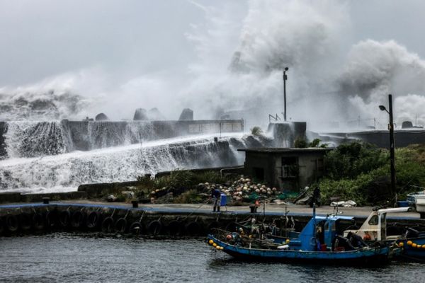
"Depending on where that system crosses the coast, the impacts are likely to be destructive wind gusts near the centre of the system, we'll see abnormally high tides and large waves in coastal areas, particularly to the east of where the system crosses the coast," he said.
"We'll also see heavy rainfall that can lead to localised flash flooding as the system crosses the coast."
A cyclone advice is current for communities between Cape Leveque and Broome, but not including Broome, with the potential for gale-force winds and heavy rainfall on Wednesday as the system passes to the north of the region while intensifying.
Squally thunderstorms with heavy falls are also expected over the northern Kimberley.
People in communities between Kuri Bay and Beagle Bay have been given the all-clear, with the threat of wind and storm surges having now passed.
Wide-reaching impacts across coast
The extended track map on the BOM's met-eye service shows the system crossing as a category four, then sweeping through the Pilbara rapidly on Friday north of Telfer and toward Uluru.
"At this stage it has [forecast] a category two system as it moves to the north of Telfer," Ms Lingard said.
But she said gale-force winds would extend a fair distance away from the centre of the tropical cyclone, regardless of its track.
"Even if the system crosses in the middle around Eighty Mile Beach, Port Hedland residents and indeed even Broome residents could be kept feeling the impacts of the gale-force winds," she said.
She said a storm surge was also likely for residents to the east of the system, with strong onshore winds.
With school holidays underway, holiday-makers are being warned to stay on top of the forecasts and heed warnings.
"It is very important to stay abreast of what is happening as things can change quite quickly with these things," Ms Lingard said.
She said travellers should download the BOM weather app and set their location each day to ensure they receive alerts.
Significant destruction feared
Department of Fire and Emergency Services Commissioner Darren Klemm said anyone in the area where the cyclone could impact needs to start preparing now.
"Now is the time to be cleaning up around your home, make sure you've got an emergency kit, make sure you're keeping up-to-date with the various warnings that come out," he said.
"There is no excuse for not being prepared. It's going to be a severe tropical cyclone, certainly a cat[egory] three and potential to be higher than that.
"It's been some 10 years since there's been a cyclone greater than cat[egory] three through this area, so people up in those communities need to make sure they're prepared."
He said anyone caravanning at Eighty Mile Beach should pack up and head south now, and that roads in the area are expected to be closed for at least two days after the cyclone hits.
Commissioner Klemm said DFES had deployed an additional 26 personnel into Broome and Bidyadanga, with some also going into Karratha.
While there were particular concerns around Bidyadanga, he said, authorities were working with officials in the town, and remote communities across the region, to ensure they were prepared and had adequate supplies.
Ms Lingard said category-four tropical systems could be incredibly destructive, as evidenced by TC Tracey in 1974 and TC Debbie in 2017.
She said mean winds could reach as high as 199 kilometres per hour, with the strongest gusts around 279kph.
"At that stage, we'd see significant roofing loss, structural damage, caravans destroyed or blown away," she said.
"And because of all that you'd have dangerous airborne debris and we'd also have widespread power failures."
A category-three system would have similar destruction, with wind gusts peaking at 224kph.
Ms Lingard said those on the fringes of the system could still experience gale-force winds, although the extent of damage in those areas would likely be less.
"Anywhere from Port Hedland to Broome could see some of the gale force winds up 90kph, with gusts in excess of 120kph," she said.
"At that sort of range we are looking at category-one or category-two strength winds.
"There will probably not be too much in terms of housing damage, especially where they're built to withstand these winds, but still damage to crops, damage to trees, caravans and water crafts."
Ms Lingard said it had been "a long time" since WA's north-west coast had experienced a system that strong, with TC Damien the last cyclone of similar strength in the region.
The cyclone season so far
This would be the first severe cyclone to make landfall in Australia this year.
But the 2022-23 cyclone season has not been without impacts.
In December 2022, TC Ellie crossed the coast as a low-category cyclone and quickly weakened to a tropical low, dumping an enormous amount of rain over the Fitzroy River catchment.
The copious amounts of water that flowed into the Fitzroy River led to what has now been described as WA's worst-ever flooding event, with extensive damage to homes and critical infrastructure.
In early February, TC Gabrielle trundled over Norfolk Island before weakening to a tropical low and inflicting widespread devastation over New Zealand's North Island, killing 11 people.
At a similar time TC Freddy, which formed in Australian waters, began its record-breaking journey across the Indian Ocean.
The system became one of the most energetic and long-lasting cyclones in history, ripping through southern Africa twice and killing hundreds.
If it eventuates, TC Ilsa will be the sixth cyclone of the season to form in Australian waters.