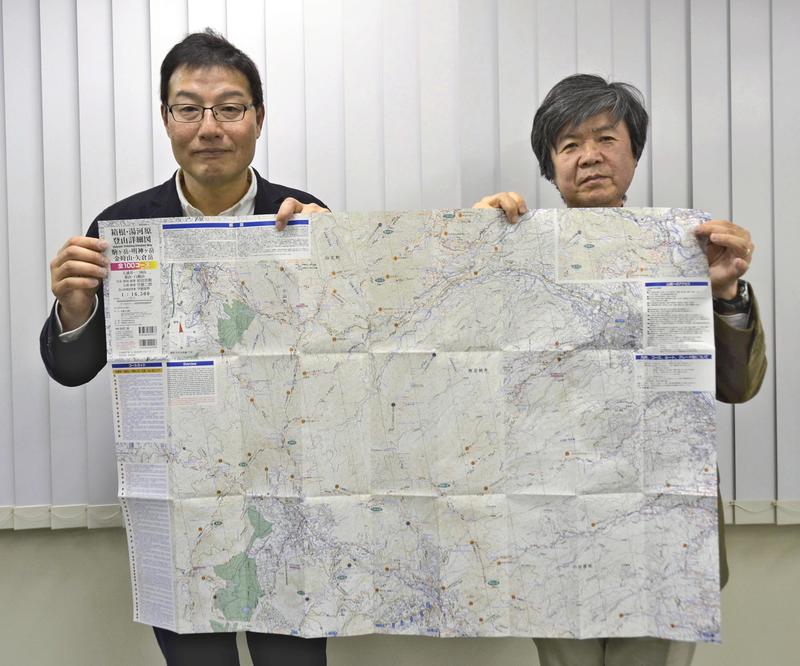
The 11th edition of the popular "Trekking: Detailed Map" series featuring the Hakone and Yugawara region has been completed by contributors led by creator Jiro Moriya and his hiking buddy Atsutaka Maeda, a professor at the University of Tokyo.
Hakone is a popular tourist area that can be easily reached from Tokyo -- via the Odakyu Line, for example. The new edition will help readers explore local history and culture, as well as enjoy grand views of Mt. Fuji and other natural sites.
Moriya, 51, hails from Musashino, Tokyo. He has created 10 previous editions of the map since March 2011, selling more than 140,000 copies.
With help from friends and using an odometer, Moriya measured each trail to give the map accurate information on difficulty and distance. The map includes regular routes and more challenging alternatives.
Maeda, 60, from Shibuya Ward, Tokyo, and 20 others helped create the latest edition. Maeda is a materials science researcher who studies superconductors and other fields. Hiking the mountains near the metropolitan area is his hobby, and he has been to the Tanzawa Mountains more than 600 times and to the Hakone area at least 130 times.
The new Hakone and Yugawara edition took almost two years to put together, and was finished last month.
It centers on Mt. Komagatake (1,356 meters) in the Hakone central cone, and comprehen-sively covers outer-rim mountains such as Mt. Kintoki (1,212 meters) and Mt. Myojingatake (1,169 meters). It also includes walking courses that pass through mikan orchards with a view of Sagami Bay, and hiking paths that pass through ume orchards.
The area is popular with foreign tourists, so important passes and other place names are also written in English.
Hakone has long been an important area in east-west transit, and is home to the remains of many checkpoints, castles and the like. "It's great to be able to walk in nature while experiencing history and culture, all on a day trip from Tokyo," Maeda said.
Moriya said, "We tried to include as many routes as possible that don't appear on other hiking maps and tourist guides."
Maeda was attacked by hornets while making the map, and Moriya encountered a mamushi pit viper.
The scale of the Hakone and Yugawara map is 1:16,500, and it is priced at 900 yen before tax.
Moriya has been selling it at an outdoor stand at the Kobotoke Pass hiking trail, and it can be found at hiking supply stores in Tokyo and Kanagawa Prefecture. It is also available at bookstores in the metropolitan area.
For more details, contact the Tokyo office of Kibito Publishing Inc. at (0422) 38-7902.
Read more from The Japan News at https://japannews.yomiuri.co.jp/