An amber cold health alert has come into force as several yellow weather warnings for ice and snow have been issued in large parts of the UK this week.
The UK Health Security Agency updated the cold weather alert on Monday as the Met Office warned that overnight temperatures could drop as low as -10C. The amber warning is in place for the North East, North West and Yorkshire and the Humber, while a yellow alert is in place for the rest of England from 12pm on Monday, and will be lifted at 8am on Saturday.
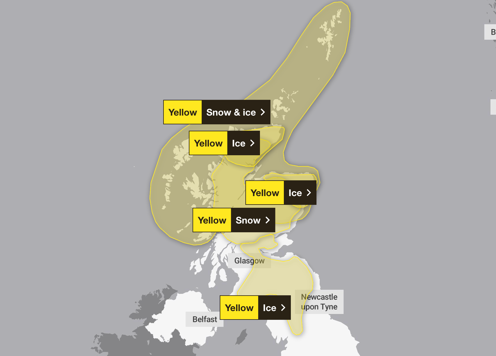
Widespread frosts are forecast across the country, with the Met Office announcing yellow ice warnings from 7pm on Monday in areas in the North East and far north of mainland Scotland. Overnight showers and low temperatures bring a risk of icy conditions on roads and pavements.
The warnings will be lifted at 10am on Tuesday, but several others will take effect from the early hours of the morning. A snow warning has been issued from 3am to 6pm on Tuesday in areas including Central, Tayside and Fife, Grampian, Highlands and Eilean Siar, and Strathclyde.
Further ice warnings have been announced in parts of northern England, as below-zero temperatures and outbreaks of rain and hill snow could bring icy conditions. A warning has been issued from 5am to midday on Tuesday.
Met Office deputy chief forecaster Tom Crabtree said: "Wednesday to Friday will be the coldest part of the week, and this period has the greatest potential for impactful weather, with multiple warnings in place.
"Overnight, temperatures could get down to minus 10C, with a significant wind chill from the strong northerly wind making things feel even colder.”
The ice and snow warnings will continue into Wednesday and Thursday, in place for parts of north-east England, south-west Scotland, Yorkshire and Humber, and northern areas of Scotland.
The warning will take effect in northern Scotland from 6pm on Tuesday until 9pm on Thursday, and in north-east England from 6am on Wednesday until 6pm on Thursday. The Met Office has forecast around 2 to 5cm of snow at low levels.
An amber cold health alert is issued when significant impacts across health and social care services are possible, which could include a rise in deaths among elderly people with health conditions, increased demand for health services, and impacts on the workforce, which could affect the delivery of services.
The UK recorded its coldest night since March on Saturday as temperatures dropped to minus 7C in Tulloch Bridge in the Highlands.

Here is the weather forecast for the UK for the coming week, according to the Met Office:
Today
Some showers in the far north and near to North Sea coasts, wintry in northern Scotland. Elsewhere mostly dry with lots of sunshine, after a frosty start for many. Cold, especially in the East, where it will be breezy.
Tonight
Showers easing to leave a mostly dry night with clear spells. A widespread frost, with icy patches. However, turning breezy and less cold in the North West, with rain and snow.
Tuesday
A bright, frosty start for many. However, rain in the North West extending South East to all parts through the day, with some snow, especially in the North. Breezy and feeling cold.
Outlook for Wednesday to Friday
Early rain and snow clearing on Wednesday, leaving very cold northerly winds with sunshine and wintry showers. Overnight frost and ice. Rain and hill snow arriving in the West later on Friday.