Many parts of Ireland will be zapped by lightning today while thunder rumbles.
It comes as Met Eireann has issued two warnings, including a rare ‘double’ alert.
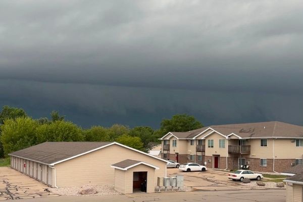
The first ‘thunderstorm’ warning is already in effect for Clare, Tipperary, Waterford, Galway, Kilkenny, Laois and Offaly.
It lasts until 11am and reads: “Moderate chance of thunderstorms. Possible impacts: Spot flooding, Poor visibility, Difficult travelling conditions.”
READ MORE: ‘Abnormal’ weather to ravage Ireland as Met Eireann issue warning for menacing windstorm
A second ‘double’ alert for both thunderstorms and rainfall begins at 1pm for Cavan, Donegal, Monaghan, Clare, Galway, Leitrim, Mayo, Roscommon and Sligo.
Lasting for 7 hours until 8pm, it reads: “Scattered thunderstorms with spot flooding and the chance of hail. Possible Impacts: Spot flooding, Poor visibility, Difficult travelling conditions.”
Met Eireann has forecast more thunderstorms throughout the rest of this week as unsettled conditions continue. However, the heat is still set to stick around with temperatures reaching as high as 21C at times.
You can track exactly where and when the storms will hit next by using Windy’s interactive lightning tracker map below.
Giving a day-by-day breakdown of what weather to expect next week, the national forecaster said: “This morning, heavy showers in Munster with some thunderstorms, will spread northwards and will become widespread by noon. Further heavy showers this afternoon and evening with some thunderstorms, spot flooding and the chance of hail, especially in Clare, Connacht, Ulster and the parts of the midlands. Highest temperatures of 17C to 21C with moderate southerly breezes
“On Monday, heavy showers in the south will gradually move northwards and will become widespread during the afternoon. They'll continue for the rest of the day with thunderstorms and spot flooding possible and a chance of hail. Highest temperatures of 17C to 21C with light to moderate southeast to east breezes.
“Tuesday will bring sunshine and showers, heaviest and most widespread through the afternoon and evening with isolated thunderstorms possible. Highest temperatures of 16C to 20C with moderate west to northwest breezes.
“Wednesday will bring sunny spells and scattered showers. The showers will be mainly in the west at first but they will spread elsewhere by the afternoon. Light to moderate westerly breezes and highs of 15C to 19C.
“Thursday will be another day of sunny spells and showers. Highest temperatures of 15C to 19C with light westerly breezes.
“Friday will be mostly cloudy with rain spreading eastwards across the country, heavy at times. It will clear to scattered showers by Friday night. Highest temperatures of 15C to 18C with moderate southerly winds.
“Next weekend will continue unsettled with showers or longer spells of rain. Temperatures will be in the wind to high teens.”