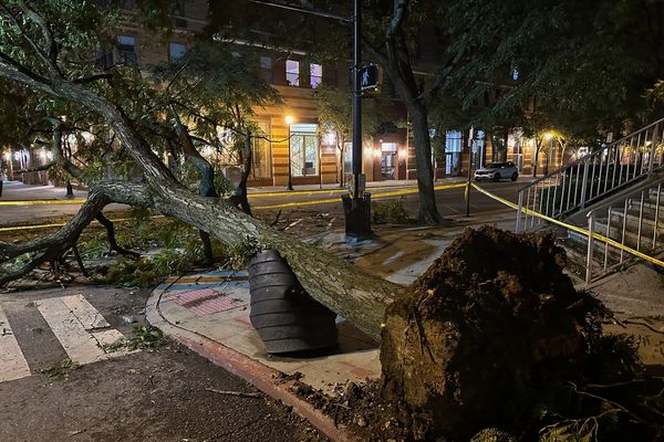
It's a familiar situation across the Greater Sydney basin and beyond once again.
Tens of thousands have been ordered to evacuate their homes, thousands more are on watch to evacuate, and millions across the city, its surrounds and beyond are battling flooded roads, mouldy homes and umbrellas that simply are not up to the task.
Time and again this year, New South Wales residents, and those in other states, have been told the rain is unusual.
In fact, Britain's BBC News is explaining to viewers how bad it is by pointing out there was more rainfall in Sydney in the four days to Monday than London normally receives in a year.
So just how unusual is it? And how much are La Niña cycles and climate change really to blame?
The ABC News Daily podcast spoke to three climate and weather specialists to find out.
Why are the NSW floods so bad again?
The reason for the severe floods affecting the Hawkesbury, Nepean, Georges and Colo rivers is not really the sheer amount of rain itself, according to senior associate at the Climate Change Research Centre at the University of New South Wales, Agus Santoso.
Dr Santoso said that, normally, this much rain would be unlikely to lead to floods of this magnitude.
However, when so much rain falls after successive periods of heavy rainfall, it has a different impact.
Widespread flooding is caused because the ground has not had enough time to properly drain and dry out.
"It's been crazy," Dr Santoso said.
"For the past two years, we've been having this wet weather, which is consistent with the occurrence of back-to-back La Niñas since the year 2020."
But isn't La Niña meant to be over now?
It is, according to the experts — although for how long remains a topic of intense observation and speculation.
Nina Ridder — a research associate at UNSW's Centre of Excellence for Climate Extremes — said the recent rains were not necessarily due to La Niña.
"What we're seeing now is probably more of a regular east coast low system," Dr Ridder said.
"It's not strong enough anymore to be classified as La Niña."
However, she said, the models are beginning to suggest another La Niña — the third in a row — was likely.
"It's really still too early to say though what the rest of the year will look like with any certainty."
The Bureau of Meteorology currently lists the likelihood of another La Niña event at 50 per cent.
But Dr Santoso — who has been collaborating on a probability forecast of a third La Niña arriving in eastern Australia — said there was now a better-than-average chance of that occurring.
"Having a third one is quite rare — in fact, since 1950, we have only had two [in Australia] — there was one in 1973-1975, and one in 1998-2000, and this could potentially be another.
"The Bureau of Meteorology surveys eight climate models, and five of them — five out of eight — point to a La Niña condition towards the end of the year."
Why are we potentially getting a third La Niña?
Both La Niña and El Niño cycles are driven by prevailing winds as well as by the movement of warm and cool bodies of water in the tropical Pacific Ocean, and Dr Santoso stressed that both were natural processes which had been taking place for thousands of years.
"When La Niña happens, essentially the trade winds over the tropical Pacific strengthen," he said.
"Those trade winds then push warm water over northern Australia, where all the moisture is piled up, and that is driving all the rain."
Dr Santoso also said, in predicting a new La Niña cycle, forecasters looked closely at temperatures over the central and eastern equatorial Pacific Ocean, where a very small difference in temperature could tip the scales.
"It's a threshold of about 0.5 degrees Celsius," he explained. "If it exceeds [that], that will be an El Niño, if it's below [that], that will be an La Niña."
Is climate change making the weather worse?
According to Dr Santoso, this year and 2021 have been much wetter than others affected by La Niña cycles, at least in New South Wales.
"For example, the week ending 24th of March, 2021 — that was the wettest week for New South Wales since national daily records began in 1900.
"And November, 2021 — that was New South Wales's wettest November since 1900 as well."
For Professor Matthew England — from the University of New South Wales Climate Change Research Centre — the comparative severity of the rainfall being experienced in eastern Australia correlates with what climate models have been predicting would happen as the Earth's climate warms.
"It's going to get, on average, more humid right through the atmosphere.
"The way to summarise it for Australia really is that we expect an intensification of the drought, flooding and rain cycles, so when El Niño and La Niña events come along, we expect them to be more impactful."
Dr Santoso had a similar prediction.
"Potentially, it is a scenario where we could have a year of bushfires, followed by a year of flooding — it's not a very good outlook, in my perspective," he said.
"I hope it won't eventuate, but we have to be prepared for what is going to come in the future."