Beaches from the Carolinas all the way to Cape Cod closed as the rapidly strengthening Hurricane Erin threatens to unleash treacherous 15-foot-tall waves, rip currents and storm surges on the East Coast.
On Wednesday, the National Hurricane Center warned beachgoers against swimming at most East Coast beaches due to “life-threatening surf and rip currents” brought on by the powerful Category 2 storm and set to last until at least Friday.
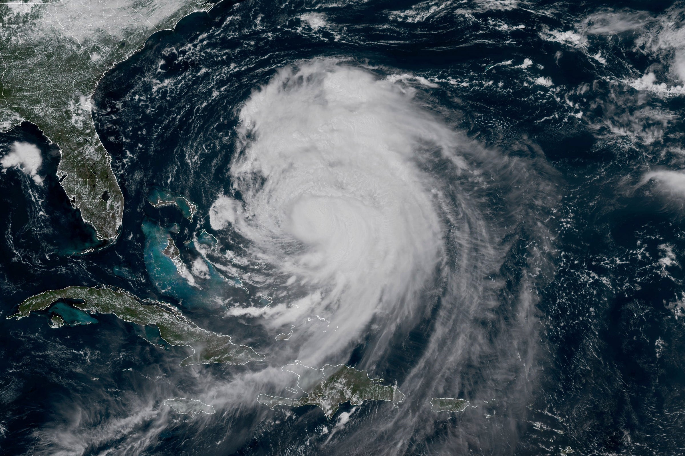
Hurricane Erin, which formed on August 11 and quickly intensified, is expected to largely impact the Outer Banks region of North Carolina and portions of coastal Virginia — though forecasters warn the storm’s impacts will also be felt in the northeast.
While the worst of the beach conditions, including three to six foot storm surge, will hit the Outer Banks, beaches along the East Coast could see up to three feet of surge, AccuWeather’s Lead Hurricane Expert Alex DaSilva told The Independent. Storm surge is the rise of sea level that can lead to flooding brought on by events such as hurricanes.
“Up the Virginia, Maryland, Delaware, New Jersey coastline, all the way up towards near New York City, there could be a one to three foot storm surge from this storm, even though the storm is going to be hundreds of miles offshore,” DaSilva said.
Many beaches along the East Coast shut down Wednesday — with plans to stay closed the rest of the week — to protect swimmers from the storm’s impact.
New York City closed its beaches to swimming for both Wednesday and Thursday, and New York Governor Kathy Hochul ordered three state beaches on Long Island to prohibit swimming through Thursday.
Several beaches along the New Jersey and Delaware coasts were also temporarily shut down, with some set to be closed until Friday or the weekend. The impacted beaches include Asbury Park, Avon-by-the-Sea, Bay Head, Belmar, Bradley Beach, Margate and Wildwood for New Jersey. Beaches affected in Delaware include Dewey Beach and Rehoboth Beach, among others.
DaSilva warned that even if the beaches open back up — and the weather looks promising — the risk of dangerous rip currents will last at least through Saturday.
“The storm’s moving away on Friday, but there’s so much energy from the storm that I think the rip current risk along the entirety of the East Coast continues through Saturday,” DaSilva said.
“I don’t want people to get a false sense of security on Friday or Saturday when the storm is moving away and they think, ‘Oh, the sun’s out, we can go back to the beach.’ It’s still going to be very, very dangerous,” DaSilva added.
Along with rip currents comes the risk of high waves. Beaches in New York, including on Long Island and in Brooklyn and Queens, could see waves as high as 11 to 15 feet on Thursday, the National Weather Service said.
The National Weather Service also issued a coastal flood watch for Brooklyn and Queens, meaning areas along the water may be susceptible to flooding.
The threat of beach flooding and beach erosion along the East Coast will increase with high tides forecasted through at least Friday morning.
The service warned of "one to two feet of inundation above ground level possible in vulnerable areas near the waterfront and shoreline."
While the hurricane isn’t expected to bring a lot of rain to the Northeast, DaSilva said the weather may feel breezier thanks to the storm.
“It’ll be the windiest inland in North Carolina, but tomorrow can still be breezy in Baltimore, Philadelphia, New York City, and even Hartford, Connecticut, areas that are well away from the ocean,” DaSilva said.
“It’s not going to be really strong, winds will be 20 to maybe 30 mph, but it still can be breezy in some of these cities along the I-95 corridor.”
The forecast indicates improving conditions by Saturday, after Hurricane Erin’s departure, as a cold front is expected to enter from the west on Sunday, potentially bringing in even more storms.
Hurricane Erin live updates: North Carolina under state of emergency as beaches close in Northeast
Hurricane Erin dramatically shifts trajectory after lashing the Caribbean with rain and high winds
Things to know about dangerous rip currents and how swimmers caught in one can escape
Why wasp numbers are booming in the UK – and why it’s actually a good thing
Hurricane Erin tracker: Live path updates as North Carolina under state of emergency
Building explodes after hit and run driver strikes gas line in dramatic video