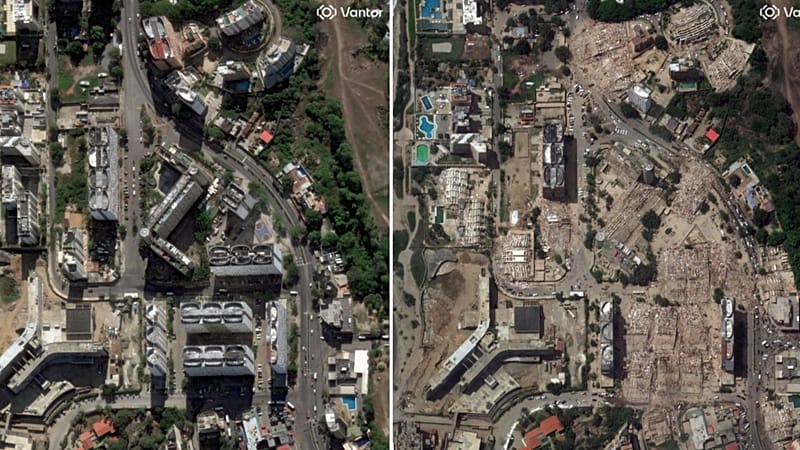
As rescue teams continue to search for survivors in the rubble of the twin earthquakes that struck Venezuela, another race is under way from space. Space agencies, tech companies and international organisations have activated a network of artificial intelligence and geospatial analysis tools to identify, within hours, the areas most likely to have been devastated and to help direct emergency resources where they are needed most.
One of the key players is NASA, which has activated its disaster response programme together with researchers at Oregon State University. Their task is to analyse radar images captured before and after the quake to detect abrupt changes in the ground and in buildings. Using this system, scientists estimate that nearly 59,000 buildings may have been damaged or destroyed, a preliminary figure that helps to steer the initial rescue efforts.
However, those images would not be possible without the European Copernicus programme. The Sentinel-1 satellites, operated by the European Union and the European Space Agency, supply the high-resolution radar imagery that makes it possible to measure ground movements of just a few centimetres and to spot buildings whose shape has changed after the earthquake. That information is the raw material on which the artificial intelligence algorithms work.
Microsoft has joined that effort through its AI for Good lab. The company has developed computer vision models capable of automatically analysing thousands of satellite images to classify buildings according to the likelihood that they have been damaged. Rather than replacing teams on the ground, these models help set priorities and highlight which neighbourhoods should be inspected first.
All that information ultimately reaches those who need it thanks to the United Nations Centre for Humanitarian Data (HDX), the platform where Microsoft publishes its damage maps so that governments, NGOs and rescue teams can consult them almost in real time. This way, different organisations work from the same database and can better coordinate the humanitarian response.
Experts stress that none of these tools replaces inspection on the ground. The maps generated by artificial intelligence provide probabilistic estimates, not a definitive diagnosis. But when thousands of buildings may have been affected and every hour counts in the search for survivors, having an almost instant snapshot of the disaster can make the difference between arriving in time and arriving too late.
This text was translated with the help of artificial intelligence. Report a problem : [feedback-articles-en@euronews.com].