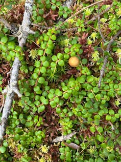
Peatlands are among the world’s most important yet underappreciated ecosystems. They are a type of wetland that covers a small fraction of the Earth’s land, while containing the most carbon-rich soils in the world.
Healthy peatlands shape water cycles, support unique biodiversity and sustain communities. Yet for all their importance, we still lack a clear picture of how peatlands are changing through time.
When peatlands are drained, degraded or burned, the carbon they hold is released into the atmosphere. More than three million square kilometres of wetlands have been drained by humans since 1700, meaning we have lost a huge amount of carbon sequestration potential globally. This makes it all the more important for us to understand and conserve remaining peatlands.
Traditionally, studies of peatlands have focused on a few well-researched sites, often in temperate or boreal regions. But climate change, land use pressures and extreme weather are affecting peatlands everywhere, including in remote, tropical and under-studied regions.
To predict how peatlands will change and react under future conditions, we need frequent data on different types of peatland habitats that captures how they change over seasons and years.
In our recent research, we harnessed the power of people, easily accessible technology and a research network to collect data using a distributed data approach. This means using data collected following a standardized methodology: everyone collecting similar data using the same methods regardless of location.
Read more: Canadian wetlands are treasures that deserve protection

Methods that make a difference
Our study, called The PeatPic Project, used smartphone photography to collect data. We connected with peatland researchers around the world via social media and word of mouth and asked them to collect photographs of their peatlands during 2021 and 2022. We gathered more than 3,700 photographs from 27 peatlands in 10 countries.
We analyzed these photographs to look at the plant colour, telling us how green leaves are across the year, and providing rich information on the vegetation growing there. Changes in green leaf colour indicate when plants start their growing season.
They also indicate how green or healthy plants are, how much nutrient plants take up and when they turn brown in the autumn. Colour shifts can also signal changes in moisture or nutrient conditions, temperature stress or disturbance.
This kind of science, conducted by a global community of researchers, amplifies reach. Local observers can use smartphones to record seasonal changes, water levels, vegetation colour or cover, land use or disturbance. With training, standardized protocols, good metadata and validation, community-generated data can be robust. These methods lower the cost, increase the amount of data available to researchers, and build local stewardship and global networks.

Better predictions of peatland function are not just academic; they are essential for mitigating the effects of climate change, protecting biodiversity, water security and reducing risks from disasters like fires and droughts.
Information derived from images can be converted into mathematical representations of plant behaviour and this can in turn be added into digital twins of peatlands.
Creating digital twins of peatlands can help experts simulate “what if” scenarios. For example, what happens if drainage increases after a wildfire or restoration is initiated? But to build useful digital twins, we need data in place: across biomes, seasons and scales.
Read more: What are digital twins? A pair of computer modeling experts explain
What needs to happen next
We now have easily accessible tools and technology that allow us to monitor peatlands in ways that were not possible a decade ago. But advancing this depends on action from multiple fronts:
Research networks should develop, share and adopt standard protocols and data practices so that data from different places and sources can be combined, compared and scaled.
Communities, including members of the public, can be partners in observation. Training, co-design, fairness and recognition are essential. Local observations, including smartphone photography, could feed directly into decision-making.
The public can help by supporting policies that fund this work by participating in community science initiatives and recognizing how something as simple as a smartphone photo can significantly contribute to understanding how our planet works.
In fact, the PeatPic Project inspired us to create another community science project called Tracking the Colour of Peatlands. This project involves fixed point locations on 16 peatlands around the world, where members of the public can take a photo of the peatland at different times to help us build a picture how the ecosystem changes over the year.
Peatlands are not fringe ecosystems. They matter for people, climates, water and biodiversity. Harnessing distributed data gathering across a global community, and accessible tools like smartphones gives us a chance to see how peatlands change, to predict where they are most at risk and to act ahead of crisis.
The future of peatlands, and of the Earth’s carbon and water cycles, depends on seeing, recording, sharing and acting together on what is happening now.
Scott J. Davidson receives funding from the Québec Ministry of the Environment. He is a member of the Groupe de recherche interuniversitaire en limnologie (GRIL), an FRQNT-funded network.
Avni Malhotra’s research was supported by the Swiss National Science Foundation.
This article was originally published on The Conversation. Read the original article.
.jpg?w=600)


