Get all your news in one place.
100’s of premium titles.
One app.
Start reading
ABC News
ABC News
National

From Gympie to Grafton, see the floods devastation from the air

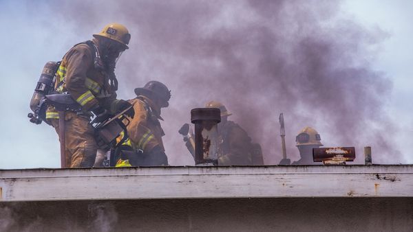
As local communities along much of the east coast deal with the muddy aftermath of extraordinary rainfall, aerial images begin to show the scale of this disaster.

Just days after our saturated rivers and creeks broke their banks, flights for location intelligence company Nearmap dodged clouds and continuing wild weather from Gympie to Grafton — a 500km stretch — to capture this imagery.

Eleven years after being hit by huge floods, south-east Queensland was first in the firing line, as a La Niña pattern turbocharged by climate change created a weather system that dumped unprecedented amounts of rain, causing flooding and widespread destruction.

A bridge in the Queensland town of Gympie. (Aerial imagery by Nearmap)

Last Wednesday, nearly 400mm of rain fell near the town of Gympie — a taste of what was to come for communities along the coast.

A bridge in the Queensland town of Gympie after floodwaters started to recede. (Aerial imagery by Nearmap)

And the rain just didn't stop.

Gympie experienced its worst flood since the 1880s, and parts of nearby Noosa were also affected.

The Noosa River and buildings along its banks, including the Tewantin Noosa Marina. (Aerial imagery by Nearmap)
The Noosa River flooded around the Tewantin Noosa Marina.  (Aerial imagery by Nearmap)

The rain slowly moved south, and locals in the town of Grantham evacuated in water up to their waist, while others were rescued from their roofs.

The rail bridge at Grantham, where floodwaters previously swept through in 2011.

Nineteen people in Grantham and the surrounding Lockyer Valley died when the area was hit by a wall of water just over a decade ago.

The rail bridge at Grantham was hit by flooding after extensive rain in the region.

While the flooding this time wasn't as devastating, residents have still returned home to a massive clean-up task.


A record-breaking deluge

As the system lingered, low-lying areas in Brisbane began to flood. But it was a record-breaking downpour on Sunday that caused much of the damage in the city, as water built up in the creeks and gullies, with no way of draining quickly.

In four days 739mm fell on the Queensland capital — nearly three-quarters of its annual average.

Oxley Creek runs through several of the city's southern suburbs, including Rocklea (Aerial imagery by Nearmap)

Authorities say the saturated creeks meant every suburb was affected this time around.

Oxley Creek runs through several of the city's southern suburbs, including Rocklea.

The area around the Brisbane Markets is prone to flooding, and this time the water wasn't moving on. 

While the waters had receded in much of the city, large parts of Rocklea were still inundated when these images were taken.

Even though the creeks were responsible for much of the damage, the Brisbane River still peaked above the major flood level.

The Brisbane River at the inner northern suburb of Albion. (Aerial imagery by Nearmap)

The peak was lower than in 2011.

The Brisbane River broke its banks at the inner northern suburb of Albion. (Aerial imagery by Nearmap)

But here at Albion in the inner north, the river still covered a major road, several days on.

Flooding around much of the city centre receded in a couple of days, but the murky waters left their mark.

Flooding in the inner western suburb of Milton was slow to recede. (Aerial imagery by Nearmap)
The tennis centre in the Brisbane suburb of Milton. (Aerial imagery by Nearmap)
Most of the courts at Milton Tennis Centre were still underwater several days after the floods hit. (Aerial imagery by Nearmap)
Heath Park in East Brisbane was swamped by Norman Creek. (Aerial imagery by Nearmap)
Floodwaters receded slowly at this intersection in Oxley. (Aerial imagery by Nearmap)

The river was awash with debris from further upstream, and Brisbane's ferry terminals — rebuilt after 2011 — caught their fair share of it.

Debris from the flooded river collected at the Hawthorne Ferry Terminal. (Aerial imagery by Nearmap)
Flood debris at Northshore Hamilton Ferry Terminal. (Aerial imagery by Nearmap)
Milton Ferry Terminal was left holding rubbish after the river flooded. (Aerial imagery by Nearmap)

The raging waters nearly caused an incident when a crane on a pontoon, which was on the river to start work on a new bridge, broke free of its moorings. 

A crane on a pontoon broke free of its moorings, forcing the closure of the Story Bridge, and the evacuation of the Howard Smith Wharves. (Aerial imagery by Nearmap)

The mud returns to Ipswich

In the suburb of Goodna locals were left to contemplate the task of rebuilding their lives again (Aerial imagery by Nearmap)

Goodna, a suburb of Ipswich, to Brisbane's west, is adjacent to the Brisbane River.

And, as in 2011, houses and businesses were flooded. 

Goodna locals were left to contemplate the task of rebuilding their lives again.

The disaster moves south

The damaging rain brought flooding all the way south of Brisbane, through Logan and Beenleigh.

A playground and car park at Beenleigh, south of Brisbane. (Aerial imagery by Nearmap)
Houses and backyards remain under water several days after they flooded at Beenleigh, south of Brisbane. (Aerial imagery by Nearmap)
A skate park is under water at Beenleigh, south of Brisbane. (Aerial imagery by Nearmap)
Flooding surrounds houses at Loganholme, south of Brisbane. (Aerial imagery by Nearmap)
A bridge emerges from receding floodwaters at Waterford West, south of Brisbane. (Aerial imagery by Nearmap)
Flooding at Waterford West, in Logan south of Brisbane. (Aerial imagery by Nearmap)
A gap in the clouds allowed Nearmap to capture Tweed Heads stained brown by the floodwaters (Aerial imagery by Nearmap)

A gap in the clouds allowed Nearmap to capture Tweed Heads stained brown by the floodwaters.

But this is only a fraction of the damage caused by the system. And by the time the rain left Queensland, 10 people had died.

Further south, the towns of Tumbulgum and Murwillumbah were inundated. And stories are emerging of landslides around Mullumbimby.

Lismore submerged

As south-east Queensland surveyed the damage, the northern NSW town of Lismore went under — facing a river peak more than two metres above the previous record set in 1954.

Locals were caught off guard by the amount of rain dumped on their town (Aerial imagery by Nearmap)

Locals were caught off guard by the amount of rain dumped on their town.

As the water rose, many were stranded on — or in — their roofs.

Terrifying stories have emerged of daring rescues by locals using their own boats.

Four people died in Lismore.
Even Lismore City Hall, the building at the top of this picture in the centre, was not spared. (Aerial imagery by Nearmap)
Lismore Memorial Baths are on the banks of Wilsons River, inside the town's levee. (Aerial imagery by Nearmap)
Despite being inside the levee, the baths were completely inundated. (Aerial imagery by Nearmap)
The Lismore Transit Centre, with the octagonal roof, backs onto the city's levee. (Aerial imagery by Nearmap)
Industrial buildings in the Girards Hill area of Lismore were still surrounded by floodwaters several days after the peak. (Aerial imagery by Nearmap)
As floodwaters recede in South Lismore, cars that were left on a bridge over Wilsons River are still there.  (Aerial imagery by Nearmap)
Richmond River High School in North Lismore is a couple of blocks from Wilsons River.  (Aerial imagery by Nearmap)

Three days after the flood, the waters still hadn't fully receded.

After the river broke its banks, all that could be seen of Richmond River High School was its roofs. (Aerial imagery by Nearmap)

The Richmond River High campus in the north of the town remained inundated.

Big River Way, the main road through Ulmarra on the NSW coast, winds along  beside the Clarence River. (Aerial imagery by Nearmap)

As did parts of the town of Grafton — a 500km journey from Gympie. 

Cars were left in a high spot among the rising waters of the Clarence River at Ulmarra. (Aerial imagery by Nearmap)

And nearby Ulmarra and Southgate.

Southgate sits on the banks of the Clarence River (Aerial imagery by Nearmap)
These houses at Southgate were no match for the Clarence River.  (Aerial imagery by Nearmap)
A farmhouse and outbuildings are almost completely submerged at Ulmarra. (Aerial imagery by Nearmap)
Floodwaters inundated these houses at Ulmarra on the NSW coast. (Aerial imagery by Nearmap)

On the ground in Northern NSW, there is growing anger at the lack of support for flood victims. People are living in cars and running out of drinking water.

As forecasters warn of more possible wild weather in the weeks to come, for thousands of Australians the ordeal is far from over.

Credits

Sign up to read this article
Read news from 100’s of titles, curated specifically for you.
Already a member? Sign in here
Related Stories
Top stories on inkl right now
Our Picks
Fourteen days free
Download the app
One app. One membership.
100+ trusted global sources.