From rivers topping 20 metres to pressure lower than Cyclone Bola to Auckland's wettest ever year, Newsroom has pulled together data illustrating Cyclone Gabrielle's catastrophic consequences
Cyclone Gabrielle is one of the most destructive storms to ever strike New Zealand.
Already, five people have been confirmed dead, more than 10,000 have lost their homes and tens of thousands remain without power. Entire regions are cut off from the rest of the country, physically and digitally, with satellite uplinks needed to communicate with local officials.
READ MORE: * Devastation toll 'beyond property and livelihoods, to people' * Cyclone Gabrielle: What makes this storm unique? * PM warns of 'bumpy time' ahead as cyclone eases
While it may be several days before we can see the full impact of the cyclone, a bevy of weather and climate data has already been released from some of the hardest-hit areas.
Newsroom has put together seven graphics that show the broken records and devastation the storm wrought.
A multi-day deluge
After days of warnings, Cyclone Gabrielle first made landfall in Northland on Sunday. It dumped a massive amount of water on the Far North and Whangārei (as we'll see later) before swinging down into the Hauraki Gulf.
While Auckland received another battering on Monday, the worst effects seem to have hit the Coromandel and then, overnight and early Tuesday morning, Tairāwhiti and the Hawkes Bay.
Gisborne, Hastings, Wairoa and Napier saw biblical flooding, but the true scale of the event still isn't known because many of the weather stations and river monitors were knocked offline on Monday evening.
Still, we have enough to show the first three days of the storm's progression in the animation below.
Among the lowest pressure readings ever
Low pressure, usually associated with storms and other extreme weather, showed up on barometers in the Coromandel as early as Saturday. Metereologists said the cyclone might break records for lowest ever pressure - and it did come close.
The 968.3 hectopascal reading in Whitianga at 3am on Tuesday is the lowest on record for the North Island other than the measurements taken during the 2008 "weather bomb". Cyclone Bola only took barometers down to 980, though the storm which wrecked the Wahine may have got as low as 964.
A summer's worth of rain
Of the major cities hit by the cyclone, Whangārei saw the most precipitation by far. More rain fell on the city between Sunday and Wednesday than it usually gets across all of summer.
That pattern is also true for Napier - and probably Gisborne as well, though the station at Gisborne Airport was taken out by the storm just before 1am on Tuesday.
Auckland's wettest year
In our largest city, long-running monitor stations allow us to see daily rainfall dating back to mid-1962. These figures show us the average cumulative precipitation Auckland gets in a year - and 2023 is already a record-breaker.
More rain has fallen in the first month and a half of this year than usually comes in the first six months of the year. The 539 mm of rain Auckland has seen in 2023 so far is seven times more than it gets on average by this time and 247 mm above the previous record.
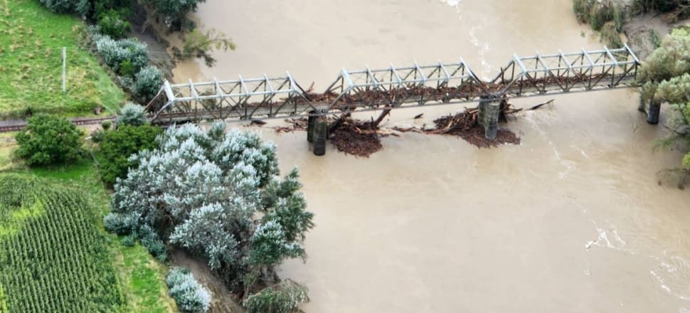
River surges
Farther south, the most devastating effects in Tairāwhiti and Hawkes Bay came partially as a result of rivers breaking their banks.
River levels around Gisborne were at their highest in the past five years of records, with the Hikuwai river topping 14m before measures were cut off.
What does that look like in practice? Here's footage from the Hikuwai River on Monday and on a normal summer day.
A similar pattern played out in Hawkes Bay, where the Wairoa River soared to a record-breaking 20m - about double its usual height. The Esk River also rose 10m, dwarfing its average level of less than a metre.