A map reveals the overnight temperatures forecast for some cities and towns across the country as the UK braces for another cold snap and snow.
Glasgow is forecast to be one of the coldest urban centres early on Tuesday morning, although forecasters say the mecury could plunge to as low as -10C in the Scottish glens.
Aberdeen, Belfast, Newcastle, Manchester and Hull also look set to experience sub-zero conditions and the Met Office has issued weather warnings for snow and ice covering parts of England, Scotland Wales and Northern Ireland.
It will be marginally warmer in southern England and the Midlands, with 0C forecast for Birningham and 3C in Southampton.
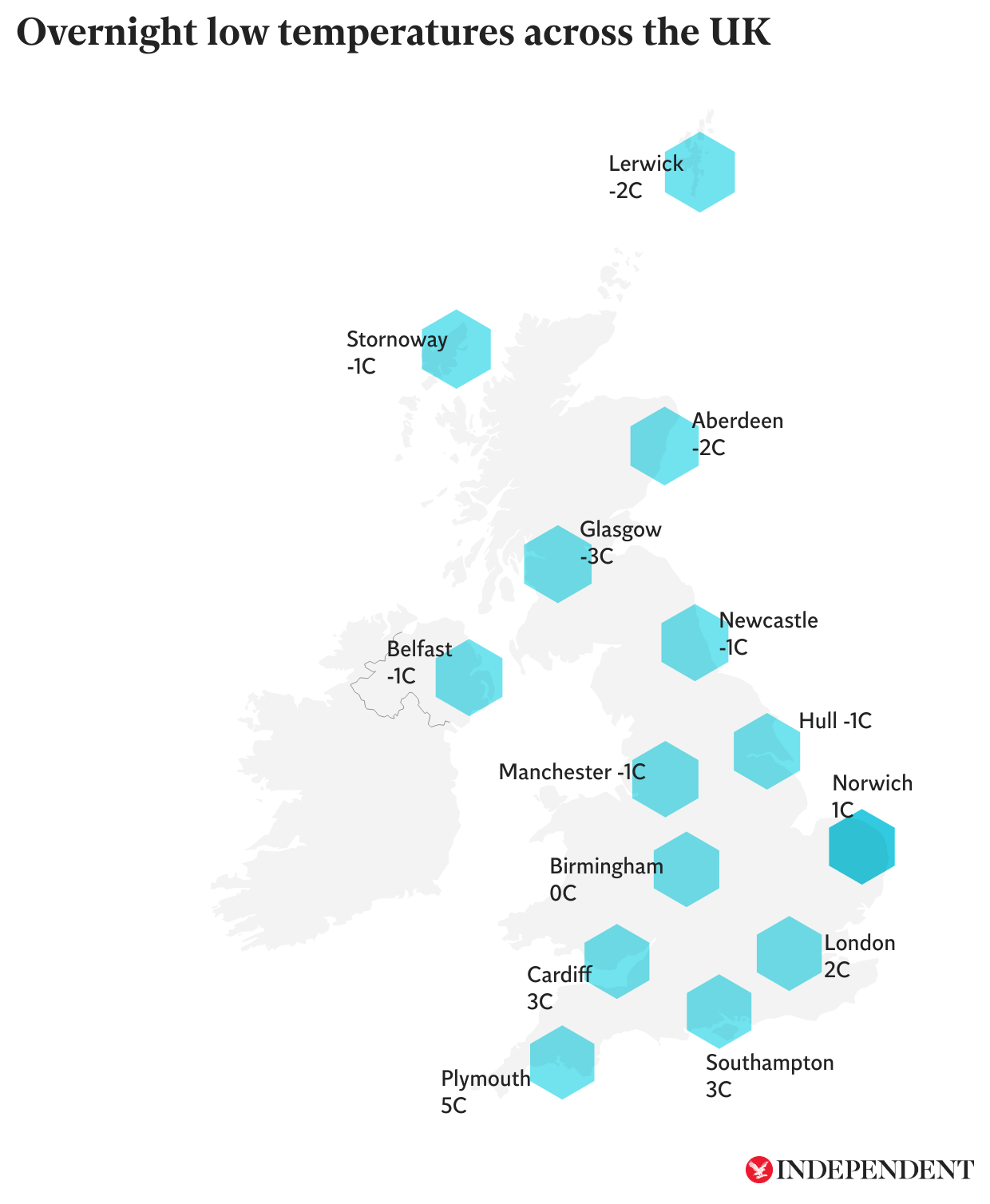
Temperatures in London will also hover slightly above freezing, with lows of 2C expected in the capital.
Up to 30cm of snow could fall in isolated spots across Scotland while other areas could see 10-20cm of snow fall.
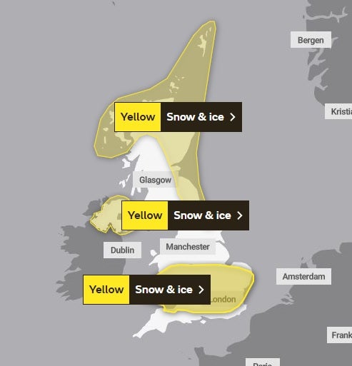
A yellow weather warning will be in place for London, the Thames Valley, East Anglia, parts of the Midlands and South Wales from 9pm on Monday night until 10am on Tuesday.
An identical one will be in place in Northern Ireland at the same time.
A yellow weather warning for snow and ice is already in place in much of northern and eastern Scotland and North East England.
The area covered by it is set to extend as far south as Hull from Tuesday before it lifts at 10am on Wednesday.
Met Office spokesman Grahame Madge said temperatures could go even colder later in the week.
The mercury could plunge to -4C in London and -6C in Birmingham and Belfast.
Mr Madge said conditions could be similar to those experienced during a cold snap in December 2022 and may not lift for almost a fortnight.
He said: "Temperatures will be much, much colder than we would expect at this time of year.
"The pattern will set in for some time. We have got this feed of cold air coming in from a much higher latitude.
"We expect these conditions to remain in place until at least next weekend and possibly longer because sometimes these conditions can be quite stubborn and not easily subject to change."
The Met Office warned travel disruption is likely and journey times by car, train and bus may take longer than usual.
People are at risk of slipping and falling on icy patches of untreated roads, pavements and paths while some rural communities could become cut off from the power grid.
Mr Madge said: "This is a disruptive spell of weather which could have quite serious consequences for some.
"Listen to the forecast, take account of weather warnings and expect to see some potentially disruptive conditions wherever you are
The UK Health Security Agency (UKHSA) has placed Nort East England, North West England and Yorkshire under a level three cold weather alert, with the rest of England at level two, until midnight on Thursday.
A level three alert means there is a 90 per cent chance of severely cold weather, icy conditions or heavy snow, which could increase the health risk to vulnerable patients.
The coldest temperature recorded last March was -9.1C in Aboyne, Aberdeenshire while on March 14 1958 the mercury dropped to a record low of -22.8C at Logie Coldstone, Aberdeenshire.