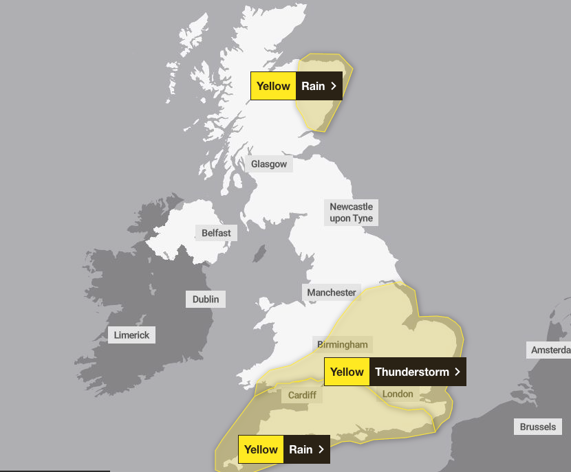
A yellow weather warning for heavy rain and strong winds has come into force across parts of England and Wales, with the Met Office cautioning over potential flooding and travel disruption.
The alert for rain is active from midnight until 2pm on Wednesday, initially impacting south-west England and much of South Wales.
The Met Office expanded the warning area early on Tuesday to include parts of south-east England. This follows the end of meteorological summer on Monday, ushering in cooler temperatures and wind after the warmest summer on record.
Meanwhile, the Northern Lights were visible across parts of the UK and Ireland overnight on Monday.
A cloudy and wet start to Wednesday for many 🌧️
— Met Office (@metoffice) September 2, 2025
Windy in the south, with coastal gales 🌬️
Stay #WeatherAware ⚠️ pic.twitter.com/7hq6gXxyP0
Stargazers on Monday night reported sightings in north-east Scotland, northern England and the Midlands, with photos on social media showing the lights as far south as West Cork in Ireland.
Tuesday and Wednesday will see night-time viewing conditions worsen, but northern Scotland and northern England are likely to have the clearest skies, although still not ideal viewing conditions.
In its weather warning, the Met Office said “heavy rain may cause travel disruption and flooding in places”.
It added that “some interruption to power supplies and other services is possible” and bus and train services will probably be affected with “journey times taking longer”.
Rebekah Hicks, chief meteorologist at the Met Office, said: “We’re expecting a band of heavy rain and strong winds to move north-east through the first part of Wednesday, followed by heavy showers and the risk of thunderstorms. Some of these could bring hail and gusty winds, particularly in southern areas.

“Of course, the warning coincides with the first school run after the summer holidays for some, meaning a wet and potentially disruptive start to the day for many.”
Heavy rain and strong winds will move north-east from early on Wednesday, followed by heavy showers and some thunderstorms.

Conditions will gradually improve from the South West through Wednesday afternoon as showers become more isolated.
Rainfall totals will be 20-30mm across much of the area covered by the weather warning on Wednesday, but some places could see 40-60mm within a period of six to nine hours.
Coastal gales are also likely for a time, especially along English Channel coasts, the Met Office added.
The weather service said conditions on Thursday would be “unsettled”, with widespread showers and occasional thunderstorms.
Some sunny spells are expected, but rain may become more persistent in parts of western Scotland.
By Friday, southern areas will begin to see more settled conditions, with increasing sunshine and fewer showers. However, the North West will remain wet and windy, with a small chance of coastal gales, the Met Office said.