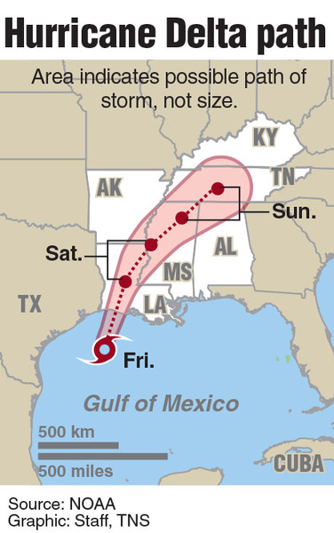
FORT LAUDERDALE, Fla. _ Hurricane Delta's eye started coming ashore in southwestern Louisiana about 6 p.m., with 100 mph winds and life-threatening storm surge, according to an update from the National Hurricane Center.
Category 2 hurricanes on the Saffir-Simpson scale have wind speeds between 96 and 110 mph. Category 3 hurricanes have wind speeds between 111 and 129 mph.
At Freshwater Canal Locks in Louisiana, a water level gauge reported storm surge inundation of over 7 feet above ground level, the hurricane center said.
Delta's outer bands are already arriving in Louisiana. Lake Charles, a few miles west of the scheduled landfall, was getting heavy rain and 60 mph wind gusts late Friday afternoon. Port Arthur, Texas, even farther west of the expected landfall, reported 5 inches of rain and wind gusts of 63 mph.
Entergy, the Louisiana electric company, estimated about 27,000 of its customers were without power Friday afternoon, according to The Weather Channel. In Texas, west of Delta's projected landfall, about 30,000 customers were without electricity, the channel reported.
Roads are clear right now with the storm so close, according to Sgt. James Anderson of the Louisiana State police. Early Friday morning, Lake Charles police reported three issues with 18-wheelers, two of which overturned due to high winds and the other jackknifed, blocking all lanes. Traffic had to be diverted, Anderson said.
On Thursday night I-10 west going into Texas was packed, which Anderson said was "puzzling."
"It seems as though for this storm event everybody wanted to go west toward Texas," Anderson said. "And people were complaining about how long it took. But they're not factoring in the fact you have contractors assisting with storm recovery (from Hurricane Laura) that are in here in addition to the local folks that are here.
"They could have traveled east and then north and had no problem at all. But for whatever reason they wanted to go to Texas and consequently had to sit in traffic, unfortunately."
Delta remains a relatively fast-moving storm. The NHC said Delta is "expected to weaken to a tropical storm tonight and to a tropical depression by Saturday afternoon or evening."
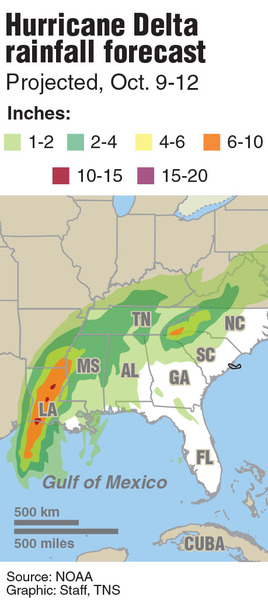
Regardless, heavy rain and a storm surge up to 11 feet are expected along portions of the northern Gulf Coast on Friday.
"The combination of a dangerous storm surge and the tide will cause normally dry areas near the coast to be flooded by rising waters moving inland from the shoreline," the hurricane center said Friday morning.
As of 6 p.m., Delta _ the earliest 25th-named storm ever to form _ was located 25 miles south of Cameron, Louisiana, traveling north-northeast at 14 mph.
Delta's hurricane-force winds extend outward from its core up to 40 miles and its tropical-storm-force winds extend 160 miles.
The NHC's 5 p.m. advisory said the Texas Coastal Ocean Observation Network station at Texas Point recently reported sustained winds of 62 mph and a wind gust of 78 mph while The National Ocean Service station at Calcasieu Pass, Louisiana, reported sustained winds of 53 mph and a wind gust of 64 mph.
Delta's threatening size is causing a large risk of life-threatening storm surge along the Gulf Coast where the tide will cause normally dry areas to be flooded by rising waters moving inland as high as 7 to 11 feet from the Rockefeller Wildlife Refuge to Morgan City, Louisiana.
Although the most intense thunderstorms in Delta are still west of the eye the biggest threat of tornadoes remains in the right front quadrant of the storm.
"The reason for that," said John Cangialosi, hurricane specialist at the National Weather Service Office in Miami, "is that winds are typically stronger on that side because it is moving in the same direction of the motion and the wind is typically coming onshore, assuming the system is making landfall, which can drag storm surge and bring the stronger winds inland."
The hurricane center said if the peak storm surge occurs at high tide, the area in Louisiana from the Rockefeller Wildlife Refuge to Port Fourchon, including Vermilion Bay, could see 7 to 11 feet of water.
Delta is expected to inundate the region with up to 10 inches of rain and isolated areas seeing as much as 15 inches in southwest and south central Louisiana.
There is potential for dangerous and prolonged flash flooding and river flooding in the region, according to the hurricane center.
Delta has been, or will be, a noteworthy storm on a few levels. Among the notable marks:
_ First hurricane named after a letter in the Greek alphabet to make landfall in the continental U.S.;
_ Second storm named after a letter in the Greek alphabet to make landfall in the continental U.S. after Tropical Storm Beta, which made landfall near Port O'Connor, Texas, on Sept. 21;
_ Strongest storm ever named after a letter in the Greek alphabet, eclipsing Hurricane Beta (2005), which reached 115 mph;
_ Fastest storm to intensify from tropical depression to Category 4 storm in modern records. Delta beat Hurricane Keith (2000) by six hours for most rapid intensification;
_ The 10th named storm to make landfall in the continental U.S., beating the record nine established in 1916;
_ Fourth named storm to make landfall in Louisiana this year, joining Tropical Storms Cristobal and Marco and Hurricane Laura. That ties a mark established in 2002 among Tropical Storms Bertha, Hanna, Isidore and Hurricane Lilli. More than 6,600 Laura evacuees remain in hotels around the state, mainly in New Orleans, because their homes are too heavily damaged to return;
Earliest 25th-named storm ever to form. The previous mark was established by Tropical Storm Gamma, which formed in the Caribbean Sea on Nov. 15, 2005;
_ Third major hurricane of the 2020 season, joining Laura and Teddy, which both were Category 4;
_ Second-strongest hurricane in the Atlantic basin this year at 145 mph, just 5 mph behind Laura.
The busy 2020 hurricane season, which has had 25 named storms, is rivaling the 2005 season, which had a record 27 named storms.
Remarkably, none of the nine storms that have made landfall in the continental U.S. this year have hit Florida. October storms often threaten Florida as they move north and then northeastward.
The Gulf Coast hasn't been nearly as fortunate.
The region was hit twice in September. Hurricane Sally made landfall on Sept. 16 near Gulf Shores, Ala., five days before Tropical Storm Beta.
Two storms hit the Gulf Coast in August in a 72-hour stretch when Hurricane Laura and Tropical Storm Marco came ashore.
July had Hurricane Hanna make landfall in south Texas, and June had Tropical Storm Cristobal make landfall in Louisiana.
Delta made landfall Wednesday in Mexico along the northeastern coast of the Yucatan Peninsula.
Delta underwent rapid intensification Tuesday, which is defined as an increase of maximum sustained winds by at least 35 mph in a 24-hour period.
Because 2020 is a La Nina year, forecasters expect late-season storm activity to increase in October and possibly even carry into November.
Accordingly, the NHC is also watching an area of disorganized showers and thunderstorms in the far eastern Atlantic. The area has a near-zero chance of development in the next 48 hours and a 20% of development in the next 5 days, the hurricane center said.
Hurricane season officially ends Nov. 30.