Communities across Australia's south-east are preparing for another round of wet weather as our weather reporter Kate Doyle joined us to answer your questions.
Look back on our blog as it happened.
Key events
Live updates
By Shiloh Payne
A look at the forecast over coming days
That's all for our blog today, thank you for joining us, and a big thank you to our weather reporter Kate Doyle for lending her expertise.
You can continue to stay up to date with the latest news here on the ABC News website and on our app.
We'll leave you with a look at the forecast over the coming days.
By Shiloh Payne
Farmers fear more flooding could reach 2011 levels
Residents across Central and North-Western Victoria fear current flooding could reach the same levels as the devastating 2011 flood event.
There's a Watch and Act in place for the Loddon River from Laanecoorie to Loddon Weir andthe Avoca River, from Charlton, down to Avoca, and around Maryborough.
Colleen Condliffe, a farmer on the Loddon River, and says they've recorded 18 millilitres of rain overnight, on top of 63 millilitres last week.
"People really have to be careful, it's dangerous. Ive been looking at it and thinking, this is not unlike 2011, leading up to 2011," Ms Condliffe says.
By Shiloh Payne
Dams are threatening to overflow in Victoria
A number of dams and reservoirs are threatening to overflow or even burst as heavy rain sweeps across Victoria, Melissa Brown reports.
Cars have become stranded in flash flooding in South Melbourne and outer suburban Frankston where a Watch and Act warning has been issued for low-lying areas.
Emergency crews rushed to Craigieburn in Melbourne's north as a private dam threatened to collapse and flood nearby homes.
You can read more on this here:
By Shiloh Payne
Heavy rain in Victoria and NSW force road closure
Roads are closed across parts of NSW and Victoria due to flooding.
By Shiloh Payne
Blue skies roll into Ballarat
After soaking rain overnight and this morning, breaks of sunshine have arrived in Ballarat.
The city recorded just shy of 25mm of rain in the 24 hours to 9AM today and has since added 7mm to the gauge.
The Bureau of Meteorology expects showers will continue to ease this afternoon, ahead of a mostly dry and cool weekend.
Reporting by Lexie Jeuniewic
By Shiloh Payne
BOM forecast more wet weather for soaked east coast
Here's an article about the forecast that weather reporter Kate Doyle put together earlier:
More rain and storms are expected today as a cold front sweeps across the nation's south-east.
Rain and thunderstorms are forecast across much of southern Queensland, New South Wales, Victoria, and Tasmania today.
The latest band of stormy weatherwill sweep from west to east and clear the east coast Saturday morning.
But that will not be the end.
A low is expected to form on Saturday, bringing get another round of rain from southern Queensland through to the mid New South Wales coast, with significant rainfall to the Sydney metro area, the Hunter Valley and the Central Coast.
The rain and storms should finallyleave the coast by Monday.
- You can keep reading this story with the link below
By Kate Doyle
A great example of not driving through floodwaters in Lancefield
Deep Creek is living up to its name at Lancefield north of Melbourne this morning. Captured by Kylie McKay
By Shiloh Payne
Crops are underwater in NSW
While western NSW cropping and livestock farmer Michael Storrier has welcomed recent rain, he would prefer if the tap could be turned off on the upstream water headed his way.
His wheat crops at Hillston near the banks of the Lachlan River were now under flood water.
"We have had 58 millimetres in the first fall, and it's been raining steady this morning and not drying out much," Mr Storrier said.
"The concern is the river is already very high and has been like for a long time, so it's the rain in the catchments that most people are worried about and if the town will get a big flood."
Before the floodwaters reached his property, his crops (wheat, canola and fava beans) were going well and most of the region's farmers were having a good season.
Recent rain saved Mr Storrier from irrigating his winter crop.
Reporting by Cara Jeffery
By Shiloh Payne
Fears of repeat of 2016 thunderstorm asthma
Here's a weather warning of a different kind from Melissa Brown:
Melbourne residents are being warned to prepare for a thunderstorm asthma event similar to the 2016 tragedy.
High grass pollen counts are expected this spring due to the wet winter and the flooding rain this week.
Thunderstorm asthma happens when gusty storms from the north-west coincide with high pollen counts, and can particularly affect people who suffer from hayfever.
Melbourne experienced the worst thunderstorm asthma event in 2016, when 10 people died and thousands suffered breathing difficulties after a severe storm swept into the city from the west.
Respiratory medicine specialist and director of research at the Royal Melbourne Hospital, Jo Douglass, said grass growth across the state had created the increased risk.
"If we get the storms and hot weather with high pollen counts, then we'll certainly be at high risk," Professor Douglass said.
"The particular threat is often after a few warmer days when the pollen counts get really high then a real storm from the north-west that can really drive the thunderstorm asthma conditions.
"We think the high pollen counts render that likely. We obviously can't predict it perfectly but it is likely to be quite a dangerous year."
Professor Douglass described it as an "environmental health emergency".
She said for many people, it escalated hayfever to asthma.
- You can keep reading this story with the link below
By Shiloh Payne
Floodwater blocks roads in Lexton
The Western Victorian town of Lexton has been hit by heavy rain on Thursday night with flood water blocking roads and creeping into houses.
Farmer Rod McErvale said the rain created higher and faster flood waters than he witnessed during the last major flood event in 2011.
"At about midnight, I had never seen the water that high," he told ABC Ballarat's Breakfast show.
"In 2011, the water at our house just off the creek in Lexton was one and a half bricks high. Last night It made it to just on four bricks, which is six or seven inches higher and a lot stronger. It has done a lot more damage."
Mr McErvale also reported trees branches and debris washing onto the roads and farm fences broken from rapid water flow.
Ballarat SES incident controller Gordon Hicks sent a crew to Lexton last night to complete a swift water rescue after a vehicle became stranded on high ground.
Mr Hicks said there were about 25 other callouts overnight and he expected the day to remain busy for his crew, with reports of roads west of Ballarat underwater and home owners requiring assistance with flooding.
He said people should not drive through floodwaters.
Reporting by Rochelle Kirkham.
By Shiloh Payne
Checking flooded roads before travelling
Hi, I was planning on travelling from Victoria to New South Wales. Where can I see what roads are closed due to flooding? Thanks!
- L
Here's Kate Doyle to answer your question:
Road data is managed state by state.
NSW use livetrafic.com
In Victoria they use VicTraffic
Stay safe out there and without sounding like too much of a broken record: Please don't drive through floodwater!
By Shiloh Payne
Flash flooding around Dubbo and Narromine
ABC reporter Romy Stephens is out and about in Dubbo and Narromine this morning.
Here's a look at the flash flooding in the area:
By Shiloh Payne
Venture out tomorrow or stay home?
How's the forecast for the weekend? My family's planning to go to the Tulip Festival in Silvan tomorrow, but I'm starting to think that's not the brightest idea. Is it going to remain this damp?
- Eda
Thanks for your question Eda, here's Kate Doyle:
Hey Eda,
It is certainly looking damp at Silvan tomorrow but the rain is not expected to be very heavy.
The detailed forecast suggests it is likely to be a persistently drizzly situation all the way until late in the afternoon. Good rain for the garden … but perhaps not so good for garden visitors.
If you do head out be sure to rug up with good boots and brollies!
You can find the detailed forecasts hidden away on the BOM website
By Shiloh Payne
What you're saying about heavy rainfall in Victoria
Callers to ABC Central Victoria's Breakfast program were quick to let us know about the heavy rainfall in the region.
Leigh texted to say there was "another 18mm in Spring Gully since yesterday morning. 62mm total over the past two days."
"36 mm after deluge at south Kyneton near Upper Coliban Reservoir," says Nadya, while Barry from Redesdale Junction says he received another 28mm.
"Patio flooded last night for the first time since 2011, about 3cm deep, but fortunately not into the house," Barry says.
"13 mm in the gauge this morning at Castlemaine. It fell overnight," says Diane.
By Shiloh Payne
Have you got a weather question for our expert?
Got a question about a third La Niña or want to know when the sun will next be out?
Weather reporter Kate Doyle is here to answer your questions.
So, what have you always wanted to know?
By Shiloh Payne
A look at the rainfall totals
Here's the latest from our weather reporter Kate Doyle:
The rainfall totals for the 24hrs to 9am are in.
The title of wettest spot in the country in the last 24 hours goes to Gray near Fingal in Tassie where 109mm hit the gauge.
The biggest falls in Vic occurred northwest of Ballarat with around 60mm.
NSW’s wettest spot was the Sydney airport, clocking up 97mm.
56mm hit the gauge at Rocky, east of Thargomindah in QLD.
While up in the tropics, 95mm fell in the remote Victoria River region.
To check how much rain hit the gauge at your place check the BOM website here.
By Shiloh Payne
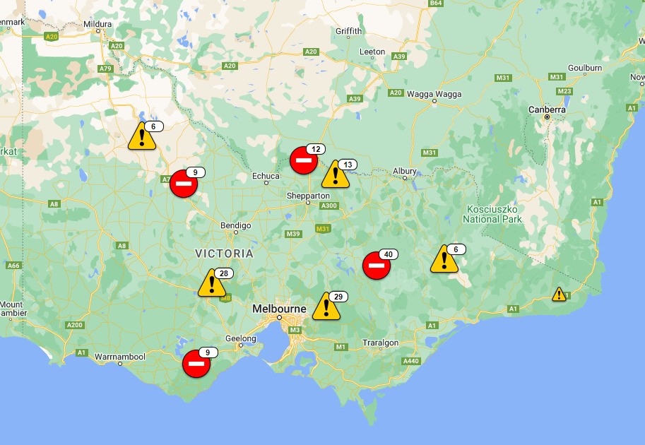
Heres what it looks like across Victoria and NSW
By Shiloh Payne
Motorists warned to stay out of floodwaters
The State Emergency Service is warning motorists to stay out of floodwaters and avoid swollen rivers after heavy rainfall across much of Victoria overnight.
In north Central Victoria, residents of Elmore and Rochester are being warned to brace for flooding — because the Campaspe River's banks have broken, downstream in Kyneton.
Jim O'Donnell, regional commander for the SES, said crews responded to two incidents in Woodend last night.
"Last night we rescued two motorists, one vehicle was swept away… and the water was only ankle-deep," he said.
The Marong unit also responded to several calls for assistance from motorists caught in flood water Thursday night.
The region's SES units are bracing for a busy 24 hours.
"We know that the catchments are already at capacity and releasing what they can, so there is minimum air space in our catchments to provide some easing of flooding."
"If you think your residence is one of these potential flood risk zones, move to higher ground."
Several roads across Central Victoria are impacted by flooding.
Bridgewater-Dunolly Road is closed, from Arnold-Newbridge Road in Arnold, to Brewery Lae in Bridgewater on Loddon.
More road closures across the Macedon Ranges and Loddon Shires are expected to be confirmed soon.
Reporting by Shannon Schubert
By Shiloh Payne
A warning for people attending the Bathurst 1000
Paul Toole, NSW Deputy Premier, spoke on the weather situation a little earlier.
He warned those attending the Bathurst 1000 to avoid camping near the river.
"We are expecting to see thousands of people here in the city enjoying the car race," Mr Toole said.
"We want to remind campers to not set up alongside the river, do not set up a campsite underneath a tree, this is for your safety."
The main concern at Bathurst is for Saturday and Sunday.
By Shiloh Payne
Widespread heavy rainfall expected over the next 24 hours
The New South Wales SES and BOM held a press conference earlier, here are some of the key takeaways:
- Widespread heavy rainfall is expected over the next 24 hours
- 5 to 50mm is forecast but there is potential for thunderstorms which could bring isolated higher totals and strong winds
- SES's areas of concern are Gunnedah, Bathurst, Forbs and Warred
- There have been 365 requests for assistance in the last 24 hours, including four flood rescues
- There are 51 warnings current across the state but no communities are currently under threat of evacuation.
- There are more than 500 SES volunteers in the field
- Anxiety is high in Hawkesbury-Nepean after four floods in 18 months
- Motorists are urged to be patient on roads, with congestion expected over the end of the school holidays.