Miles above Earth, the global effort to combat the coronavirus pandemic can be seen unfolding at a rapid and dramatic scale.
Why it matters: Tracking the effects of the virus from space can help organizations understand the pandemic without sending people into harm's way, and it can promote transparency and accountability around efforts to combat the virus.
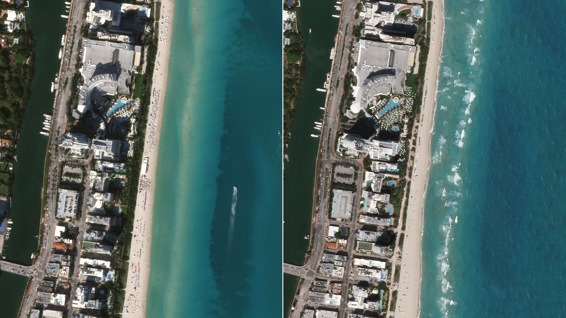
What's happening: Planet — a company that operates more than 100 Earth-imaging satellites — has been snapping before and after photos of airports, bridges and other locations to show how social distancing efforts have cleared roads and tourist destinations around the world.
- Another satellite operator, Maxar, has been tracking the construction of new hospitals and medical facilities as cities try to treat an influx of patients.
- Companies are also reporting an uptick in demand for satellite imagery showing manufacturing and infrastructure in particularly hard-hit parts of the world like China, according to a report from Space News.
The big picture: Satellite images also provide a sense of scope that can't be seen from the ground.
- A striking timelapse shows pollution clearing over China as the country enacted strict measures to slow the progression of the coronavirus crisis. (Similar photos also show pollution clearing above Italy.)
- Satellite images also show large pits being dug in Iran to bury the victims of the coronavirus outbreak in that country.
Background: Satellite data has long been used to aid in disaster relief.
- Images taken from space can also be used to track deforestation and wildfires.
A new animation showing the variation of nitrogen dioxide emissions over #China (Dec-March) – thanks to @CopernicusEU #Sentinel5P data.
— ESA EarthObservation (@ESA_EO) March 19, 2020
Sentinel-5P currently provides the most accurate measurements of NO2 and other trace gases from space.
ℹ️https://t.co/Gn9mvSnIu6 pic.twitter.com/nDLrboKnXG
Between the lines: Satellite images not only show the scope of the coronavirus crisis, but also help to hold nations and companies accountable for their actions as people on the ground work to combat the pandemic.
- "Space enables a higher degree of transparency," Dylan Taylor, the CEO of Voyager Space Holdings told Axios. "It's hard to hide from space-based assets."
What's next: It's possible remote sensing data will also be used to aid in economic recovery.
- The bird's eye view a satellite provides could help companies track the effects of the outbreak without putting employees at risk on the ground.
- Satellite data might also be able to help warn about future epidemics by keeping an eye on areas that have the potential for outbreaks to know when the risk is high for certain diseases to start spreading.