Two years after calls for urgent action, a council is still working on Mackenzie landscape protection. David Williams reports
A small South Island council has been berated for the glacial pace of its district plan review, which, it’s argued, leaves large areas of the Mackenzie Basin vulnerable to inappropriate development.
Further, there’s a warning the current timeline might lead to a development goldrush between when new protections are announced and they come into force.
The Environmental Defence Society wrote to Waitaki District Council chief executive Alex Parmley last month, raising concerns about how long its review is taking.
The current plan was made operative in 2010 and the council resolved to review it four years later. A discussion document was released in 2019 but a draft plan isn’t out yet.
(A district plan is a rulebook, the discussion document says, which controls where activities and development happen, and how land is used and developed.)
Concerns centre on the Mackenzie Basin’s special values, the public interest in protecting those values, and what might be lost. Waitaki’s council has jurisdiction over half of the Mackenzie Basin – the other half is in the Mackenzie District Council area.
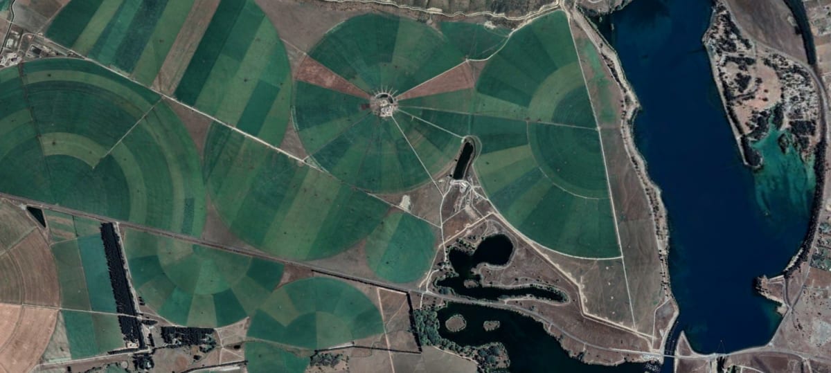
“Looking at the Mackenzie half compared to the Waitaki half, there is a lot more intensification that's happened on the Waitaki side,” EDS solicitor Cordelia Woodhouse tells Newsroom. “And the reason for that is that they've got a much more lenient plan framework.”
Piecemeal policy-making in the Mackenzie led to greener landscapes and a huge decline in biodiversity and indigenous vegetation cover. In response, a Mackenzie “agency alignment” group was formed, allowing greater information-sharing between the Department of Conservation, Land Information NZ, Canterbury’s Regional Council, and the Waitaki and Mackenzie councils.
In 2019, the agency group commissioned Boffa Miskell, an environmental and planning consultancy, to review statutory documents to find gaps in the management of landscape, water quality, biodiversity, and land-use change.
The review found the councils’ different approaches to managing farming – like irrigation, cultivation, top-dressing and oversowing – on areas identified as “outstanding natural landscapes” had huge consequences, potentially.
“Permissive” rules could allow pastoral intensification and agricultural conversion of about 38,500 hectares within the Mackenzie Basin.
The report says: “The implications of these differences could have significant effects on the landscape values and biodiversity values within the Mackenzie Basin in the Waitaki District, and could lead to a marked difference in these values between the Mackenzie and Waitaki Districts.”
Waitaki’s inadequate protection was an important headline in EDS’s own report on landscapes in the Basin/Te Manahuna, released in 2020.
(That same year, the Ministry for the Environment submitted on Waitaki’s plan review.)
Protection is so poor it might be illegal, EDS says – because, in planning parlance, it fails to give effect to the Canterbury Regional Policy Statement.
What has happened since the reports highlighting the Waitaki plan’s deficiencies? Not much, EDS argues.
The agency alignment group appears to have “dropped off”, Woodhouse says. “It just all seems to have gone quiet, which is surprising.”
However, Katherine Trought, director of strategy and planning for ECan, Canterbury’s regional council, says the agency alignment group’s chief executives’ forum last met late last year, but the interagency officers’ and managers’ forums have each met twice this year.
Waitaki district council’s heritage and planning manager, David Campbell, says as part of the review the council has completed masterplans for smaller towns, including Otematata, Ōmārama and a Spatial Plan for the Ōamaru-Weston-Kakanui area. It has also mapped about 250 significant natural areas, and commissioned two landscape architects to update landscape classifications. Affected landowners have been consulted.
“Despite being a relatively small council we have committed a considerable resource including a dedicated in-house team and a group of consultants working for us on the district plan review,” Campbell says.
There are 2.6 full-time equivalent staff working on the plan. The council has set aside $1.2 million for work on the plan over the next two years.
“Each of the 37 new chapters of the draft district plan have completed their councillor workshop phase and are currently going through an integration process.”
Campbell says council approval for the release of the draft plan will be sought in May, followed by 12 weeks of public consultation. After working through feedback, a proposed plan will be publicly notified sometime next year.
He adds: “We do not agree that the current plan is unlawful, and it provides various protection measures now.”
ECan confirms the Waitaki plan must give effect to its regional policy statement, and is the district council’s statutory responsibility. In saying that, ECan staff have been helping Waitaki after a call for help with its review in 2019.
Since then, ECan director Trought confirms, its staff have: helped with initial review work and wrote a chapter on activities on the surface of water; reviewed draft chapters; gave advice on biodiversity and natural hazards chapters; and are writing chapter summaries “for all draft chapters”.
Woodhouse says EDS isn’t mollified by Waitaki council’s response to its letter – especially the idea, a reasonably orthodox one, admittedly, of a gap between releasing the draft and notified plans.
“It’s the goldrush argument. If you know the rules are changing, and you can see that coming, you go and do your intensification, or you go and do your activities.”
A way to get around that – something EDS will be pushing Waitaki to do – is to give the announced plan immediate legal effect. “That means you can’t go and just screw up the place before those rules are changing.”
“They're just concerned about the death by 1000 cuts.” – Simon Williamson
The genesis of more intense, irrigated farms in the Waitaki was the district’s hydro-electric power scheme. When productive land within farm stations was flooded, other flat land was farmed more intensively.
To offset the loss of land, the Government promised to provide access to irrigation water. Stations started taking advantage of that offer in the 1970s.
Dairying arrived in the Basin in 2003 – pioneered by Doug McIntyre, who farms near Lake Ruataniwha, in the shadow of Table Hill.
In a 2014 article in the Otago Daily Times, McIntyre’s neighbour Simon Williamson, at Glenbrook Station, recalled the property had no fence along the main road, was denuded, was riddled with hieracium and rabbits. Wilding trees out the back were “as thick as hairs on a cat’s back”.
McIntyre had shown foresight buying the property, his neighbour said – and he’d done an “incredible job” with water.
Williamson, an immediate past chairperson of Federated Farmers’ high country industry group, says farmers aren’t keen on development rules in the Waitaki being tightened. “They're just concerned about the death by 1000 cuts,” he tells Newsroom.
On significant indigenous biodiversity, he says: “Farmers are looking after anywhere that’s indigenous that is special.”
(That theory’s debunked by 2017 research from academic Ann Brower, which found, through satellite imagery, a huge decline in indigenous vegetation cover in the Mackenzie Basin between 2001 and 2016, with thousands of hectares modified. Much of that change was on Crown pastoral leases, or on former leased land freeholded through tenure review.)
Earlier in 2017, Environment Court Judge Jon Jackson was so concerned by the rapid loss of large areas with inherent values in the Mackenzie, he called for an immediate moratorium of the freeholding of pastoral lease land.
Sure, Williamson says, thousands of hectares were irrigated through Benmore Irrigation – including 500ha on his station, Glenbrook. But tenure review also vested thousands of hectares in the Crown. Farmers have also put protective covenants on their land, he says.
“The area is well protected.”
(Further research by Brower challenges that view. It noted the greening or intensification of the Mackenzie had more than doubled in size since 2003, from 20,000ha to 45,000ha. Irrigating, fertilising, topdressing and over-sowing land leads to the loss of rare plant species and ecological values, Brower told Newsroom in 2018, adding: “You’re chopping conservation off from the knees.”)
Williamson worries councils are employing “green people” and landscape architects recommending land be shut up and it’ll go back to native, “but it won’t”.
(Again, there’s scientific research to dispel that. A 2016 article in the New Zealand Journal of Ecology found indigenous vegetation returned to the Lake Tekapo Scientific Reserve 18 years after it was dominated by mouse-ear hawkweed and grazed by sheep.)
There needs to be a balance between development and conservation in the Mackenzie. “What they need to do is look at what they've already got under QEII and DoC,” he says. “You can’t just set up rules so that no one can ever develop anything else because no one can go forward like that.”
Setting rules and strangling development ignores issues in the Mackenzie Basin, Williamson says.
There’s hieracium, degrading land, and soil loss. And then there’s the wilding trees, on land now being managed by DoC after tenure review. To coin a phrase: “They're coming up like hairs on a cat's back.”
To put the Waitaki District Council into perspective, its total revenue, including rates, is $56.5 million this financial year, much more than neighbouring Mackenzie district ($22.6 million), but less than Central Otago ($62.2 million) and Queenstown-Lakes ($220.8 million).
So how did the much-smaller Mackenzie council get so far ahead of Waitaki on landscape protection, and stricter rules on farm development?
It notified a plan change in 2007 to better protect landscape values, and its decision, made in 2009, sparked appeals to the Environment Court. The court then issued a series of decisions over the following nine years.
In its eleventh decision, in 2017, the court said the nationally important landscapes, and threatened plant species, should be better protected from inappropriate pastoral intensification.
“It’s been a great outcome,” says Woodhouse, of environmental lobby group EDS. But she gets a sense its neighbouring council, Waitaki, might be reluctant to follow the same path. That, and it knows, with such a powerful farming lobby, there’ll be a backlash when the rules do change.
“It does suck out a lot of resource and both capacity and funding,” Woodhouse says of the district plan review, and subsequent court battles. “But that doesn't mean there isn't a reason to do it.”