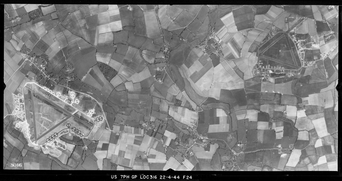
Way before Google Earth, there was photo reconnaissance by the U.S. Army Air Forces.
During World War II, specifically in 1943 and 1944, reconnaissance units of the USAAF — the predecessor to the U.S. Air Force — captured photos of the changing face of England, primarily around the American bases in the south of the country.
More than 3,600 of their black and white images were made available Wednesday in a free online, searchable map through the archive of Historic England, a public body that seeks to champion England's history and environment.
From showing U.S. military personnel playing baseball to ancient monuments surrounded by anti-tank defenses, the collection gives a bird’s-eye view of the impact of the war on England and the training that was necessary ahead of bombing and reconnaissance missions over Nazi-occupied Europe.
Unsurprisingly, the dozens of new airfields that were built by U.S. forces feature heavily, as do the military camps and storage facilities constructed in the run-up to D-Day in June 1944. Towns and cities were also captured, including the 1941 bomb damage at Manchester United Football Club’s Old Trafford stadium, one of the most northernmost photographs in the collection.
“Our collection of USAAF wartime photographs were taken in England by the pilots and aircraft of squadrons that provided intelligence for the eventual defeat of Nazi Germany,” said Duncan Wilson, Historic England's chief executive. “This came at a cost, with many pilots killed in the line of duty.”
The U.S. military started arriving in England in early 1942 after the United States joined the war against the Axis Powers following the Dec. 1941 Japanese bombing of Pearl Harbor. As the U.S. build-up of troops gathered pace in the ensuing years, pilots took photographs during flights over local areas near their bases to gain the necessary experience for operations over Nazi-occupied Europe.
The aircrafts used by the reconnaissance units had their guns and weapons removed to accommodate fixed cameras and additional fuel tanks for long-range missions. With the cameras fitted with an array of lenses and focal lengths, the photographs were able to capture large areas with precision, a crucial tool for the Allies as they geared up for the invasion of Europe.
"They help to highlight the vital role aerial reconnaissance played in the Second World War," said Wilson.