10.46am: The Bureau of Meteorology is reporting that the Hunter River at Maitland has peaked at 10.41 metres slightly below the major flood level of 10.5 metres.
Moderate flooding is occurring at Singleton and Maitland.
Minor flooding is occurring at Raymond Terrace.
The Hunter River at Singleton is currently at 12.41 metres and falling, with moderate flooding. The Hunter River at Singleton is likely to remain above the moderate flood level (11.50 metres) until Friday evening.
The Hunter River at Maitland (Belmore Bridge) peaked at 10.41 metres around 07:30 am Friday 08 July and is currently at 10.40 metres and steady, with moderate flooding.
The Hunter River at Raymond Terrace is likely to peak near 3.00 metres Friday evening, with minor flooding.
7.30am: The Bureau of Meteorology's has forecast the possibility of major flooding at Maitland this morning as the Hunter River continues to rise.
The river is currently sitting at 10.39 metres and is expected to peak later this morning at 10.50 metres.
Heavy rainfall since Sunday morning has caused significant river level rises along the Hunter River and it's tributaries.
Along the Wollombi Brook minor flooding is occurring at Wollombi where the river level peaked above the March 2022 flood with major flooding. Major flooding is occurring at Bulga where the river level peaked well above the March 2022 flood and is 1.0 metre higher then the 1952 flood.
Along the Lower Hunter River, moderate flooding is occurring at Singleton where the river level exceeded the March 2022 flood peak (13.15 metres) Wednesday afternoon and peaked at 13.71 metres early Thursday morning.
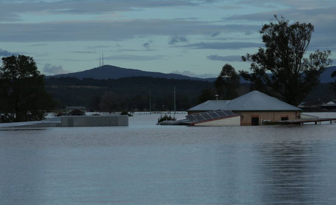
Moderate flooding is occurring along the Lower Hunter River at Maitland where major flooding is possible Friday morning.
In other news:
- Maitland flood July 2022: city smashes July rainfall records
- The residents going through evacuations all over again
- The little libraries popping up in Maitland streets
- How to prepare for a flood
- What's on around Maitland this weekend
Minor flooding is occurring along the Hunter River at Raymond Terrace.
Moderate flooding is occurring at Singleton. Moderate flooding is occurring at Maitland, with Major flooding possible. Minor flooding is occurring at Raymond Terrace.
The Hunter River at Singleton peaked at 13.71 metres around 03:00 am Thursday 07 July and is currently at 12.76 metres and falling, with moderate flooding. The Hunter River at Singleton is likely to remain above the moderate flood level (11.50 m) until Friday afternoon.
The Hunter River at Maitland (Belmore Bridge) is currently at 10.39 metres and rising slowly, with moderate flooding. The Hunter River at Maitland (Belmore Bridge) may peak near the major flood level (10.50 metres) Friday morning.
The Hunter River at Raymond Terrace is currently at 2.88 metres and peaking, with minor flooding. The Hunter River at Raymond Terrace may remain above the minor flood level (2.50 m) until Friday night.
The following road closures are now in place:
- Oakhampton Road, Oakhampton closed (between Heath Avenue and Mount Pleasant Street)
- Paterson Road closed, from the Dunmore Bridge in Woodville to Lang Drive
- Raymond Terrace Road closed, from McFarlanes Road to Port Stephens Council boundary
- Metford Road, Metford near the new hospital towards Raymond Terrace Road. Detours are in place.
- High Street, Maitland from Wallis Creek Bridge to Honda dealership
- Newcastle Street, East Maitland off High Street
- Railway Parade, Telarah
- The following remain closed due to water over road:
- Alnick Road, Millers Forest
- Anambah Road, Gosforth
- Anne Street, East Maitland
- Athel D'Ombrain Drive, Maitland (from Railway Street to Bent Street)
- Bent Street, Maitland closed
- Bourke Street, Maitland
- Brisbane Fields Road, Morpeth
- Brush Farm Road, Raworth
- Bungaree Street, Telarah
- Cessnock Road is closed at both ends, isolating Gillieston Heights. Police, SES and traffic control are in place.
- Cultivation Road, South Maitland
- Devonshire Street, Maitland (between Grant St and Abbot St)
- Dickenson Road, Melville
- Duckenfield Road, Berry Park
- Eales Road, Berry Park
- Elgin Street, Maitland (at the roundabout into Athel D'Ombrain Drive)
- Fitzroy Street, East Maitland
- Grant Street, Maitland
- Gullivers Lane, Louth Park
- Hinton Road, Phoenix Park between Phoenix Park Road and the Hinton bridge.
- Junction Street, Telarah
- Ken Tubman Drive, Maitland, Maitland between the High Street traffic lights and the corner of High Street and Ken Tubman Drive. Note, that the Belmore Bridge is still accessible.
- Lawlers Road, Phoenix Park at the Phoenix Park Road end
- Lee Street, Maitland (at intersection with Nicholson Street)
- Louth Park Road, intersection with Trappaud Road, Louth Park
- Louth Park Road, Louth Park closed from Reflection Drive to Gullivers Road
- Luskintyre Road, Luskintyre between the Luskintyre Bridge and approximately 200m from the Windemere Road intersection
- Maitland Vale Road, Lambs Valley near the Luskintyre Road intersection
- Maitland Vale Road, Rosebrook (near Maitland Vale/Luksintyre RFS)
- Martins Wharf Road, Millers Forest
- Mcfarlanes Road, Morpeth
- Melbourne Street, East Maitland (at the railway pass, between Brisbane and Adam Street)
- Melville Ford Bridge
- Metford Road is closed in two locations (between Raymond Terrace Road roundabout and Maize Street and beneath the rail bridge between the roundabout and Fieldsend Street).
- Morpeth Road, Raworth (near Linuwel School) closed
- Morpeth Bridge closed
- Mount Dee Road at Junction Street, Telarah
- Nalley's Creek Road, Millers Forest
- New England Highway closed between Melbourne Street and old hospital roundabout with detours in place.
- Park Street, Maitland (corner of Park and Elgin Street)
- Pender Road, South Maitland
- Phoenix Park Road, Phoenix Park, between Morpeth Bridge and Hunter Street, Largs
- Pitnacree Road, Pitnacree (access still possible via Flat Road and Melbourne Street)
- Pywells Road, Luskintyre
- Raymond Terrace Road, East Maitland closed (at 3 Mile Gully between Harvest Road and Metford Road) and before the roundabout with detours in place before Tenambit Street, East Maitland
- Scobies Lane, Oakhampton Heights
- Smith Street and Rose Street intersection, Maitland
- Steam Street, Maitland
- Testers Hollow, Gillieston Heights
- Unicomb Road, Largs - the last 500m towards Phoenix Park Road
- Victoria Street, Maitland
- Windermere Road, Windermere
- Woodberry Road, Millers Forest between Alnwick Road and Nilands Lane (detours in place)
Drive cautiously. Water reported over the road at:
- Campbells Road, Maitland Vale
- Grant Street, Maitland
- Glenarvon Road, Lorn
For further information regarding road closures and to stay up to date, see here mait.city/Alerts
Flood Safety Advice:
In life threatening emergencies, call 000 (triple zero) immediately. If you require rescue, assistance to evacuate or other emergency help, ring NSW SES on 132 500.
- * Avoid drowning. Stay out of rising water, seek refuge in the highest available place.
- * Prevent damage to your vehicle. Move it under cover, away from areas likely to flood.
- * Avoid being swept away. Stay out of fast-flowing creeks and storm drains.
- * Never drive, ride or walk through flood water. Flood water can be deceptive and dangerous.
For more emergency information, advice, and access to the latest river heights and rainfall observations and forecasts:
- * NSW SES: www.ses.nsw.gov.au
- * RMS Live Traffic: www.livetraffic.com
- * Latest River Heights and Rainfall Observations: www.bom.gov.au/nsw/flood/midnorth.shtml
- * Latest NSW Warnings: www.bom.gov.au/nsw/warnings/
- * Rainfall Forecasts: www.bom.gov.au/australia/meteye/
- * BOM NSW Twitter: www.twitter.com/BOM_NSW
Do you know you can subscribe to get full access to all Maitland Mercury stories? Subscribing supports us in our local news coverage. To subscribe, click here.