The Garmin Unbound Gravel presented by Craft Sportswear returns on June 3 in Emporia, Kansas. Back in 2006 only a 200-mile route through the Flint Hills was offered for adventure seekers, and now the Life Time group, which organises its third edition this year, has expanded the offerings to six total distances.
The signature race of Unbound Gravel is still the 200-mile event, which begins and ends on the pavement in downtown Emporia. It delivers tyre-slicing flint and chunky rocks across washed-out gullies, punchy climbs and sun-drenched prairie in the middle of the US. The single-loop format follows roads and paths which organisers describe as “primitive”. Weather plays a big role in the off-road battle as well, with rain that swells small creeks at stream crossings and turns dirt to heavy mud, or the wind creating chaos with dust and “liquid hills”.
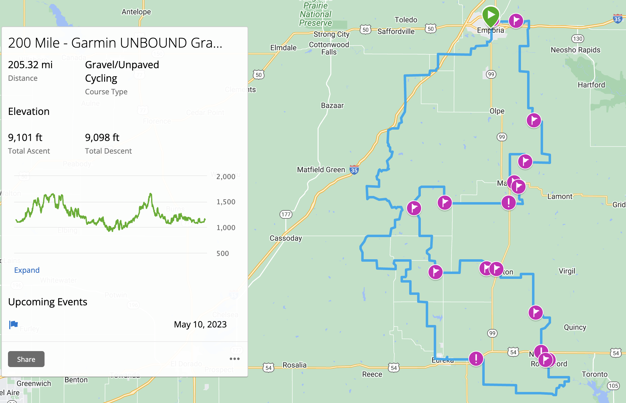
The 2023 route for Unbound Gravel 200 is one mile longer than last year, coming in at 205.5 miles. The prairies are deceiving as mountain peaks don’t pierce the skyline, but the relentless rolling hills bring 9,100 feet of elevation gain.
This year’s route again moves in a counter-clockwise direction from Emporia, skirting Interstate-35 as it leads riders south-west for a series of stiff climbs. Texaco Hill rears its head just 42 miles into the route, where there is one of two ‘water oasis’ locations. No support crews are allowed at an oasis, as it is just for hydration; and the second oasis in Madison has a store to purchase snacks.
Then it is off towards Eureka and the first of two checkpoints. This is where support crews are allowed at the local high school with 79 miles covered. The route turns west for approximately 17 miles and then begins to head north passing Walnut Creek and Rocky Ford for the lowest elevation of the route. That means it is mainly uphill for the next 48 miles, with a final water oasis in Hamilton.
With 60 miles to go, the longest stretch of climbing goes over a different section of Texaco Hill. From the top it is about 20 miles to checkpoint number two in Madison at the Madison City Park. The final northward push to the finish back in Emporia is 37 miles away, with just a couple of turns to the west and back north.
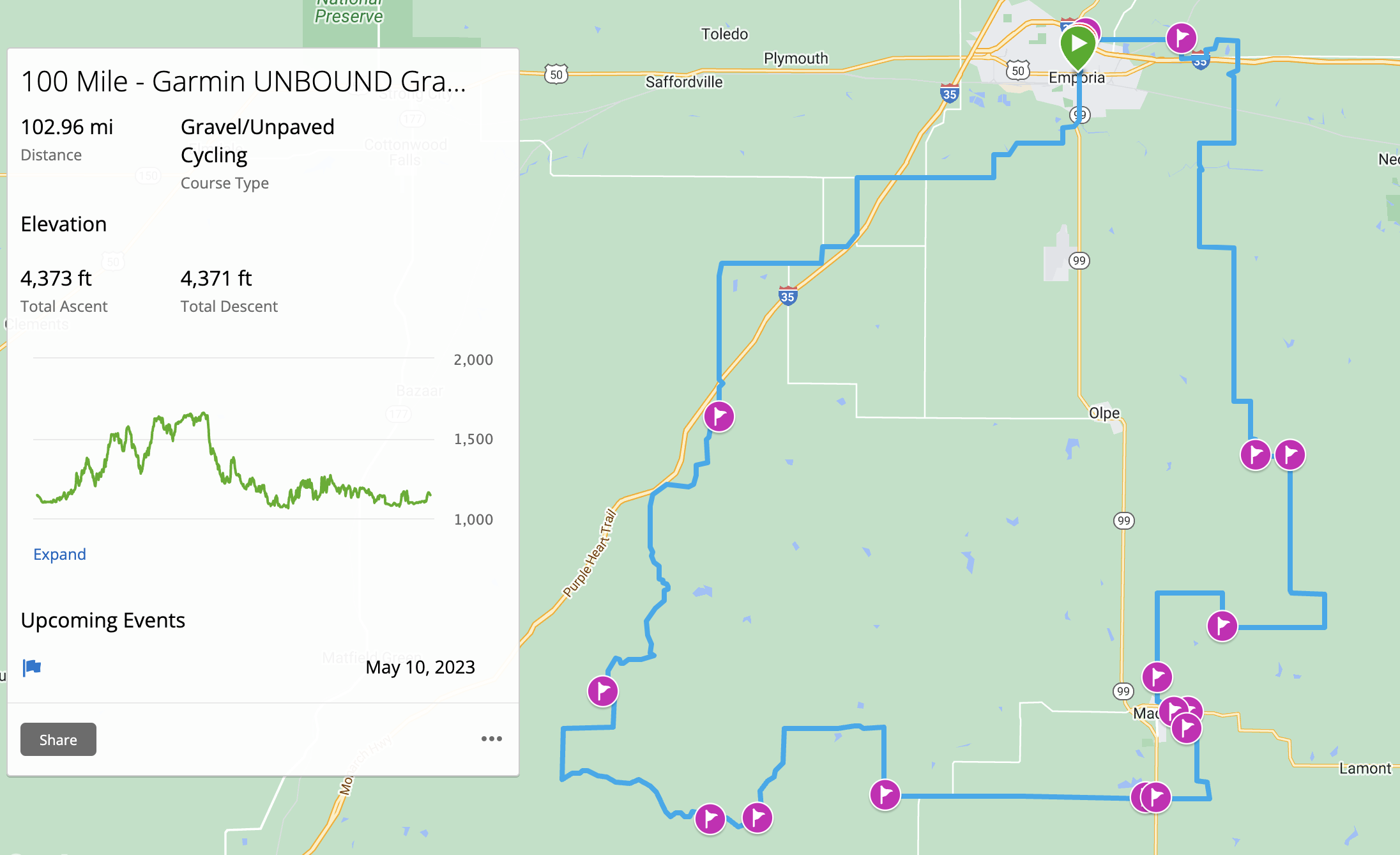
The 100-mile route uses the a shorter loop of the 200, making one pass over Texaco Hill to rider directly east to Madison and then turning back north.
Race organisers have provided information about the types of terrain that return to Unbound Gravel, as well as sections that are new for this edition:
Course highlights 2023 - new sections
- D Hill - The first hill outside of Emporia comes at mile 10. This hill hasn’t been used since 2015, as it leads to a rustic road that is prone to becoming a muddy mess with heavy rain, which was the case eight years ago.
- 270th St & K Road - From mile marker 59 thru 63 is the approach to Bee-Yotch hill. It is a punchy little climb into a curving, doubletrack descent before the big climb.
- Horse & Buggy Highway - This second is nine miles long, and is the half-way section for the 200 milers (mile 96 through 105). A secluded road with a series of rollers leads to a crossing over the Verdigris River at Rocky Ford Crossing. This was last used in 2016 when the water was waist high.
- Thrall - This is another beautiful, open range road that leads for three miles through the ghost town of Thrall, in Greenwood County. From there it is 60 miles to the finish.
Course highlights 2023 - climbs, curves, cows
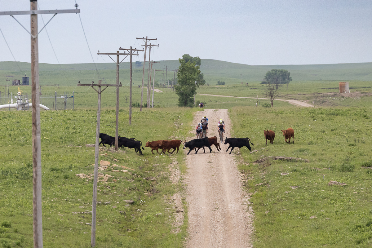
- Cattle area - Mile 20 to 27 cover open range using rough roads through open range area. These are private roads so no pre-rides are permitted in this area. Also, mind the cows.
- Texaco Hill - Mile 40 to 43 offer amazing views from the top of the ridge if you have time to enjoy. Be prepared for a rowdy descent after cresting the top, sometimes called “water bottle hill” (fasten the bottles).
- West Creek - Mile 110 to 120 cover rolling roads along the creek bottom and little hills around West Creek, heading into Hamilton.
- Texaco Hill Redux - Mile 143 to 146 is a climb, up and over the Texaco ridge once again, bit on a steeper road.
- Judge’s Hill - Mile 151 is a loose and rocky climb before heading into Madison.
- Road 10 - Mile 164 is the infamous ‘mud road’ from last year where even the race leaders were slipping and sliding.
- Rocky Ford (Bird) Bridge Descent - Mile 193 is an off-camber, curving descent onto an old re-purposed railroad bridge, and Emporia is very close.