Nearly a foot of rain could fall on parts of the UK this week, forecasters have warned, as the remnants of two storms sweep across the Atlantic.
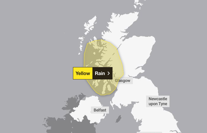
The Met Office has already issued a 37-hour yellow rain warning for western Scotland, in place from 5pm on Wednesday until 6am on Friday.
The alert currently covers parts of Argyll, Ayrshire, Dunbartonshire and Renfrewshire, but the weather service suggested the warning may soon extend to other areas following the arrival of Hurricane Humberto and Hurricane Imelda, which have caused disruption in the US.
Marco Petagna, a senior operational meteorologist at the Met Office, wrote on social media platform X (Twitter) on Tuesday: “Ten inches of rain not out of the question over the highest ground in western Scotland in the next few days... pretty incredible rainfall totals.”
Deputy chief meteorologist Chris Bulmer added that “persistent” rain will develop from Wednesday, with the heaviest downpours over the hills. “Pulses of heavier rain will extend more widely at times,” he said, adding that later in the week the picture “becomes more complex” as the storms move across the Atlantic.
He warned: “If this materialises, we could see some very strong winds as well as further heavy rainfall Friday into Saturday, but at this time the development and track of this system remains uncertain. We’re monitoring this closely.”
The Met Office said there was a “possibility of further warnings being issued later this week as confidence increases”.
For now, conditions are expected to be split between northwestern areas and the southeast. Northern Ireland, western Scotland and northwest England will see the wettest weather in the first half of the week, while the south and east should remain drier, with some sunshine and temperatures passing 20C.
A spell of very wet weather is on the way for western Scotland later in the week 🌧️
— Met Office (@metoffice) September 29, 2025
The persistent rain may lead to transport disruption and flooding, so stay up to date if you have travel plans in this area ⚠️ pic.twitter.com/gZh5CFJfEt
But from late Thursday into Friday, wind and rain are expected to spread more widely across the UK as the Atlantic systems begin to influence conditions.
Imelda, currently a tropical storm, has already battered parts of the Caribbean and was forecast to strengthen into a hurricane on Tuesday. Humberto, downgraded from category 5 to category 3, remains near Bermuda with maximum sustained winds of 115mph.
Neither system has yet met the criteria to be named by UK forecasters, but both could contribute to the first significant autumn storm this weekend.
Here is the weather forecast for the UK for the coming week, according to the Met Office:
Today
Staying largely dry and settled across England and Wales, with some sunny spells. Cloudier in many parts of Scotland and Northern Ireland with some outbreaks of rain at times and brisk winds. Feeling pleasant in any sunshine.
Tonight
A spell of persistent and heavy rain will move into Northern Ireland and Scotland, and some parts of Wales and northwest England. Dry and chilly elsewhere with patchy fog.
Wednesday
Cloudy and breezy in the north. Heavy rain will gradually clear to the east, but further rain is expected in western Scotland. Dry elsewhere with sunny spells developing.
Thursday to Saturday
Further heavy rain in the northwest on Thursday, drier in the south. Turning wet and windy for all as we head towards the weekend, with gales likely in the north.
5 homes collapse into the surf of the Outer Banks as hurricanes rumble in Atlantic
Households urged to take action ahead of October 1 energy price rise
National Flood Insurance Program is set to expire Tuesday, halting new policies and some home loans
Starmer seeks to restore pride in Britain amid plans to take on Reform
Starmer to refine international law stance in bid to tackle mass migration