Britons have been enjoying temperatures hotter than the Algarve this weekend, but the mercury is set to plunge once again next week.
The Met Office has said that brisk northeasterly winds bringing cooler air are likely to lead to widespread rural frosts and cold nights from Monday onwards.
Showers are also expected in some areas in England at the start of the week, which will otherwise be dry with sunny spells.
The winds are forecast to pick up along some south and east coasts, while a light breeze is likely for the rest of the country.
The wintry mornings and nights are expected to bookend Thursday, Friday and Saturday, which are most likely to be dry with variable cloud and some clear and sunny spells thanks to a particularly large area of high pressure stretching from Scandinavia to Greenland.
Forecasters say it should remain dry in most areas, with some showers expected in the north, which will later on into the week emerge in the far south.
The start of May is most likely to be settled across much of the UK with clear or sunny spells under an area of high pressure.
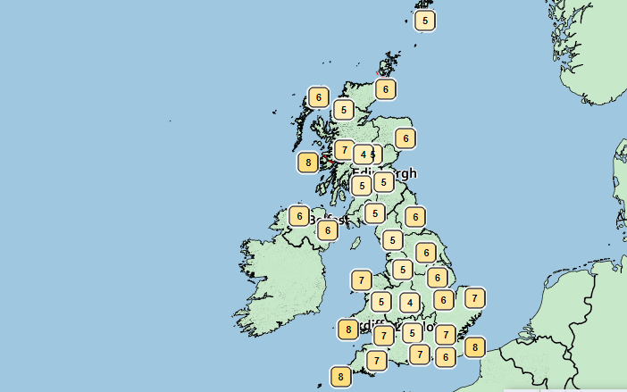
Saturday has so far brought plenty of spring sunshine across parts of the UK today, with highs of 18C.

Met officials have said that a few showers could edge over southern and western areas this afternoon, but added it should remain dry elsewhere.
For people with tree pollen allergies, forecasters have warned that there are now moderate to high levels across most of the UK.
In addition, UV levels will be moderate at times, even with areas without sunshine, over the next few days.
BBC weather forecaster Louise Lear said: “A lot of dry weather across the UK once again. Cloudier skies in the south first thing, clearer skies north and west and so a chillier start here.
“That easterly feed continuing to bring quite a lot of cloud first thing and thick enough for a few showers in the Midlands, south Wales and into south-west England. Eventually the cloud should break up and the sunshine comes through but the best of the sunshine again reserved for north west England, western Scotland and Northern Ireland.”

She continued: “Breezy, cooler here along that east coast, 12C or 13C but with some sunshine we could see 16C to 18C as an afternoon high.
“Now still that low pressure is causing some issues across France bringing some heavy snow potentially late in the season in the Alps.
“Plenty of isobars across the UK, the wind still continuing to be a feature but that north-westerly wind may well break up the cloud a little quicker on Sunday so more sunshine coming through.”
MET OFFICE WEATHER
Saturday evening:
Some showery rain possible in the far south. Dry with clear spells elsewhere, though low cloud affecting some northeastern areas, especially across Scotland. Chance of rural frost in parts of the north and northwest. Breezy in southern and eastern parts.
Sunday:
Most parts dry with broken cloud and sunny spells. A few showers possible, mostly across central and eastern England during the afternoon. Brisk northeasterly winds slowly easing.
Outlook for Monday to Wednesday:
A few sharp showers on Monday, mainly for southeast England, otherwise dry with sunny spells. Breezy along south and east coasts; light winds elsewhere. Chilly by night with rural frosts.