The UK is expected to enjoy hotter temperatures than Barcelona this weekend.
Temperatures will soar into the mid-twenties on Saturday and Sunday, the Met Office has predicted, as the UK’s sunny spell continues.
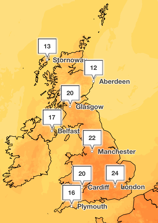
The mercury is set to peak at 24C in London and the south east of England on Sunday, with temperatures of 20C stretching into the north of England and south Scotland.
Coastal areas to the west of the country will experience cooler temperatures in the mid to late teens, with Plymouth experiencing temperatures of 17C. Skies will remain clear and bright across the UK for the most part, with some cloudy patches towards the west.
Met Office meteorologist Honor Criswick said “it’s going to be a dry and pleasant day ahead” on Saturday with “wall to wall sunshine in some spaces”.
Meanwhile, Spain’s top holiday destination will see temperatures peak at 18C on Saturday and 22C on Sunday. This comes as other regions of Spain and the Balearic Islands have been hit with a Status Orange storm warning, with thunderstorms predicted in the northern regions, including Barcelona and Madrid.
Popular hotspots across Catalonia, Andalusia, Castile and Valencia put storm alerts in place on Thursday afternoon, stretching into Friday, with forecasters warning of the possibility of snow in higher areas.
AEMET, the state weather agency, has warned that there is a possibility that the conditions will be “accompanied by hail”, with poor weather set to continue throughout the weekend.

Spain’s poor weather is being caused by a low-pressure system moving in from the Atlantic, as well as a cold air mass that is making its way across the Iberian Peninsula.
This region of low pressure risks pushing into the south west of England on Sunday, with the Met Office warning of heavy showers towards Devon and Cornwall.
The Met Office forecaster added: “We need to keep an eye across the South as we head into Sunday. Just this area of low pressure could potentially push up something across the South West. Heavy showers, these possibly turning into some thundery downpours, so something we need to keep an eye on for Sunday.
“But for many of us, it should be a dry end otherwise the weekend.”
The UK has so far experienced record-breaking sunshine so far this year. The Met Office clocked an average of 228.9 hours of sunshine across last month, meaning the UK recorded its sunniest April since the series began in 1910. This follows the sunniest March since records began for England.
May started off with the hottest day of the year so far as the Met Office recorded 29.3C in London.

Today
Early morning mist and low cloud soon clearing, otherwise a dry day with plenty of warm sunshine. Breezy in the North West and South East, but warmer for most compared to recent days. Dry with mainly clear skies allowing isolated mist and fog, and rural frost. Cloudier in the far North West with patchy light rain later. Breezy in the far North West and South East.
Saturday
Mist and fog soon clearing. Another fine, dry day with plenty of warm sunshine for most. Cloudier and breezy in the far northwest with patchy rain. Generally warmer than Friday.
Sunday to Tuesday
Turning warmer and cloudier on Sunday with showers arriving for some, mainly in the South West, these turning heavy and thundery by Monday. Showers easing and becoming cooler through Tuesday.