The UK is set for cold and frosty weather after the mercury soared past 20C last week.
Unsettled weather conditions are set to spread across the country, as temperatures fall with the risk of frost and ice for some parts of the UK, the Met Office has said. No weather warnings are currently in place.
It comes after last week’s warm and bright weather saw the warmest day of the year so far, with 20.9C recorded in Wales on Wednesday.

Met Office deputy chief forecaster Steven Keates said that by the middle of the week, rain, strong winds and cold air would take over from the mild front the UK saw last week.
“After a spell of mild and brighter weather, the UK will turn increasingly unsettled in the coming days,” he said. “A series of weather fronts will bring periods of rain, strong winds and much colder air by midweek. Wednesday could be quite a shock to the system.

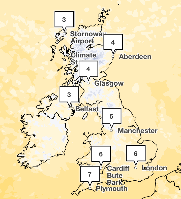
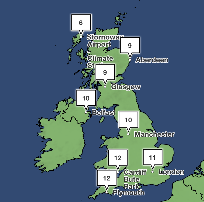
He added: “Temperatures will range from 6C to 10C, but it will feel closer to low single figures for many areas in the wind.
“Wintry showers are likely, especially over higher ground in the north, and a widespread frost – with icy patches for some – is possible on Wednesday night. It should be a little milder again by the end of the week, with many areas seeing another spell of rain on Friday.”
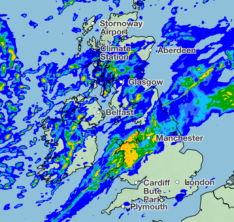
Tuesday will take a wet and windy turn for many, according to the forecaster, with heavy, persistent rain across parts of northern England and Wales. Blustery showers will move into Scotland and Northern Ireland, with hail and thunder possible, as well as wintry showers over higher ground.
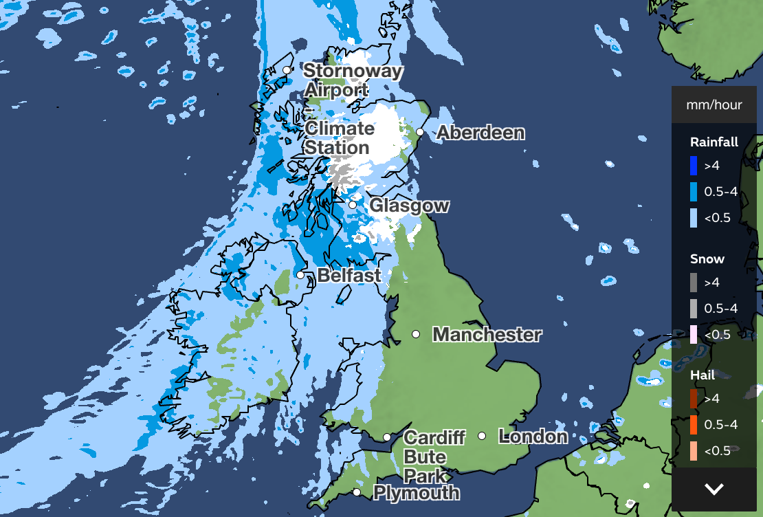
The temperature will take a cold turn by Wednesday, with rain, sleet and hail showers widely, and snow possible over higher ground in the north.
Elsewhere, it will be a blustery day. Although there is some sunshine on offer, it will feel cold thanks to the wind chill. Temperatures will fall overnight – potentially to -5C in rural Scotland – with a widespread frost overnight possible for most, and ice at first in the north on Thursday morning.
Most places remain dry with sunny spells on Thursday, although cloud and rain pushes into Northern Ireland and western parts later on.
Temperatures return closer to average from Friday onwards, though further weather systems may affect the UK at the weekend, most likely affecting northern areas.
This week’s Met Office forecast
This Evening and Tonight:
Rain will sink southwards into Northern Ireland and northern England through this evening and overnight, accompanied by strong winds. Frequent showers following across Scotland. Staying largely dry further south with a few mist and fog patches in southern England. Mild.
Tuesday:
A wet and windy day in the north, with heavy rain across parts of northern England. Blustery showers continuing for Scotland and Northern Ireland. Generally brighter towards southeast England.
Outlook for Wednesday to Friday:
Turning colder over the next few days. Sunny spells and blustery showers on Wednesday with snow over the hills. Drier on Thursday, then cloudy on Friday with outbreaks of rain.
Parts of the UK to see temperatures up to 22C as warmest day of the year expected
UK weather map: Where will see a sunny weekend after snow and wind warnings
Met Office warns gale-force winds to hit UK as cold snap returns
Steps to ensure flagship hospital met expected standards branded ‘inadequate’
Man has application to become a bin man rejected twice – despite working for free
Who are Harakat Ashab al-Yamin? The terror group linked to Golders Green arson attack