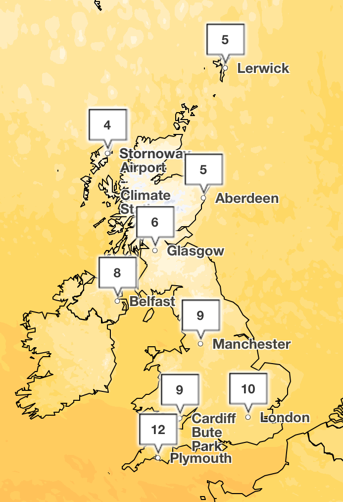
The UK is set for more cold weather and a sprinkling of snow after cold Arctic air brought wintry conditions over the weekend.
Temperatures have dipped into single digits thanks to a “cold northerly airflow this weekend” after Saturday and Sunday were predicted to be the “coldest pair of days so far this season”.
While Sunday morning got off to a chilly yet sunny start across central and eastern parts of the UK, clouds over Northern Ireland and Scotland are set to bring outbreaks of rain moving southeastward throughout the day, with some colder air moving across Scottish mountains, with the chance of a little snow.
Greg Dewhurst, a Met Office meteorologist, said: “We’ve had a cold northerly airflow across us so far this weekend, but all eyes to the northwest as this next weather system brings cloud and rain in from the northwest and sweeps it southeast across the country over the next 24 hours.
“It remains blustery into the beginning of next week, but signs of a bit more Atlantic weather coming in, allowing temperatures to rise a little further as the week goes on.
He continued: “But this morning a chilly start, particularly where we’ve got the sunny skies across central and eastern parts, but it quickly clouds over across Northern Ireland and Scotland, with outbreaks of rain moving in here and pushing slowly southeastward through the day.
“The rain could bump into some colder air across the Scottish mountains to give a little snow here, not unusual for the time of year, and the rain by the afternoon reaching the higher ground of Wales and the southwest of England, the southeast of England, generally staying cloudy, but perhaps thick enough by the end of the afternoon for some light and patchy rain developing here.
Temperatures are set to remain similar to Saturday’s, which ranged from eight to 12C, with cloud and wind coming in from the northwest as it gets colder into the evening.

The latest forecast comes after Storm Benjamin battered the UK this week with heavy downpours and winds over 70mph. Four yellow weather warnings were issued by the Met Office for Thursday, while over 40 flood alerts were in place in the morning.
Monday:
Sunny spells and a scattering of showers to start. These easing with sunny spells through the afternoon, but cloud increasing in the west with rain arriving by the evening. Breezy.
Tuesday to Thursday:
Remaining changeable with some further rain or showers at times, especially in the northwest. Always driest and brightest towards the southeast. Temperatures recovering to near average for most.
Symptoms and advice as tuberculosis cases surge in the UK
Snow expected in UK over weekend with ‘coldest days of season so far’
Advertised UK rents reach new record high
Christmas housing market slowdown starts early as price growth ‘stalls’ in some areas
Andrew ‘agrees to leave Royal Lodge on condition he gets new home’: Latest
Crackdown urged by family of mum who died after receiving illegal ‘skinny jab’