The Philippines is bracing for what may be another storm following the havoc caused by Typhoon Kalmaegi. The super typhoon referred to internationally as Fung-Wong or locally, Uwan, is predicted to be growing in intensity as it approaches the archipelago, making a possible landfall by Sunday.
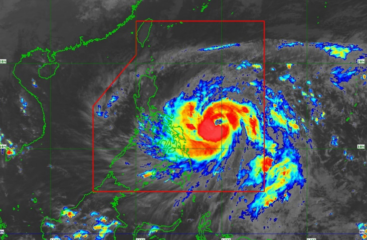
State meteorologists of the Philippine Atmospheric, Geographical, and Astronomical Services (PAGASA) said in the early hours of Sunday, 9 November 2025, that Typhoon Uwan has grown in intensity. Classed as a category five cyclone, Typhoon Uwan was last seen 370 kilometres west of Virac, Catanduanes. The storm is said to be picking up a maximum sustained winds of 165 kilometres per hour with a gustiness of up to 205 kilometres per hour.
Typhoon Uwan is also moving west-northwest at a speed of 35 kilometres per hour. Due to its speed, PAGASA meteorologists also warned that Uwan may make landfall in Luzon, over the Isabela-Aurora region, by Sunday night rather than Monday morning.
'Because of its faster movement, it is possible that Uwan would make landfall at the Isabela-Aurora area by Sunday night. We can see based on our latest satellite images that the cyclone has a huge diameter and it can affect a huge part of Luzon and Visayas, especially in areas where the centre of the storm would pass through,' said weather expert Obet Badrina.
Badrina also did not rule out the possibility of the typhoon making landfall or approaching closely over the Catanduanes area, especially as it moves toward the Bicol region. Based on PAGASA's forecasts so far, Typhoon Uwan would be over the waters of Pandan, Catanduanes by 11:00 AM local time.
'We can see that there is a possibility that the sidewall of Uwan's eye, which is the strongest part of the cyclone, would hit parts of Catanduanes. This may happen by Sunday morning, during which Uwan is closest to Bicol, particularly the eastern side of the area,' said Badrina. 'That's why we are not ruling out the possibility that the center of the cyclone would hit Catanduanes, it can still happen.'
More Areas Marked at Signal No. 3
PAGASA has already raised its Tropical Cyclone Wind Signal number three to more areas; five in Luzon and Visayas on Saturday. This signal indicates the typhoon's wind speeds ranging from 89 to 117 kilometres per hour and can potentially pose a moderate to severe threat to life and property.
'UWAN is forecast to rapidly intensify and may reach super typhoon category tonight or tomorrow, although the potential for a much faster intensification is not ruled out due to a favorable environment,' said the agency in its bulletin on 5:00 PM local time.
PAGASA has also issued gale warnings over the northern, southern, and eastern seaboards of Luzon, the eastern and central seaboards of Visayas, and the eastern seaboard of Mindanao.
In Luzon, the areas currently affected by the raised typhoon signals include:
- Catanduanes
- The eastern region of Camarines Sur
- The eastern portion of Albay
- The northeastern portion of Sorsogon.
In Visayas, the area now marked with signal number three is the northeastern region of Northern Samar.
- The rest of Northern Samar
- The northern region of Eastern Samar
- The northern region of Samar
Typhoon signal number two was also raised in many areas of Luzon and Visayas. Signal number two indicates a wind speed from 62 to 88 kilometres per hour, and can pose a mild to moderate threat to life and property.
The areas in Luzon include:
- The eastern portion of mainland Cagayan
- Isabela
- Quirino
- Nueva Vizcaya
- Aurora
- Nueva Ecija
- Bulacan
- Metro Manila
- Rizal
- Laguna
- Quezon
- Marinduque
- Camarines Norte
- The rest of Camarines Sur
- The rest of Albay
- The rest of Sorsogon
- Burias Island
- Ticao Island
Residents of the affected regions, including the coastal parts, have already been urged to evacuate ahead of the typhoon's arrival. Surrounding countries are also closely monitoring Typhoon Uwan's movements as Typhoon Kalmaegi currently sweeps through Vietnam after passing through the Philippines.