What's the weather like in your area? Tweet us at @rapplerdotcom.
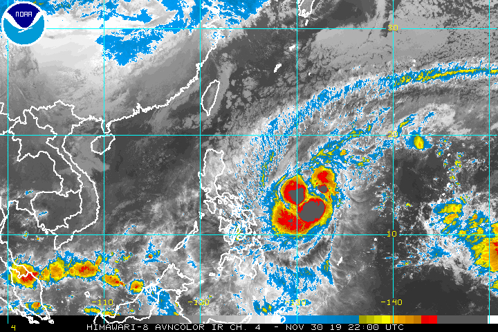
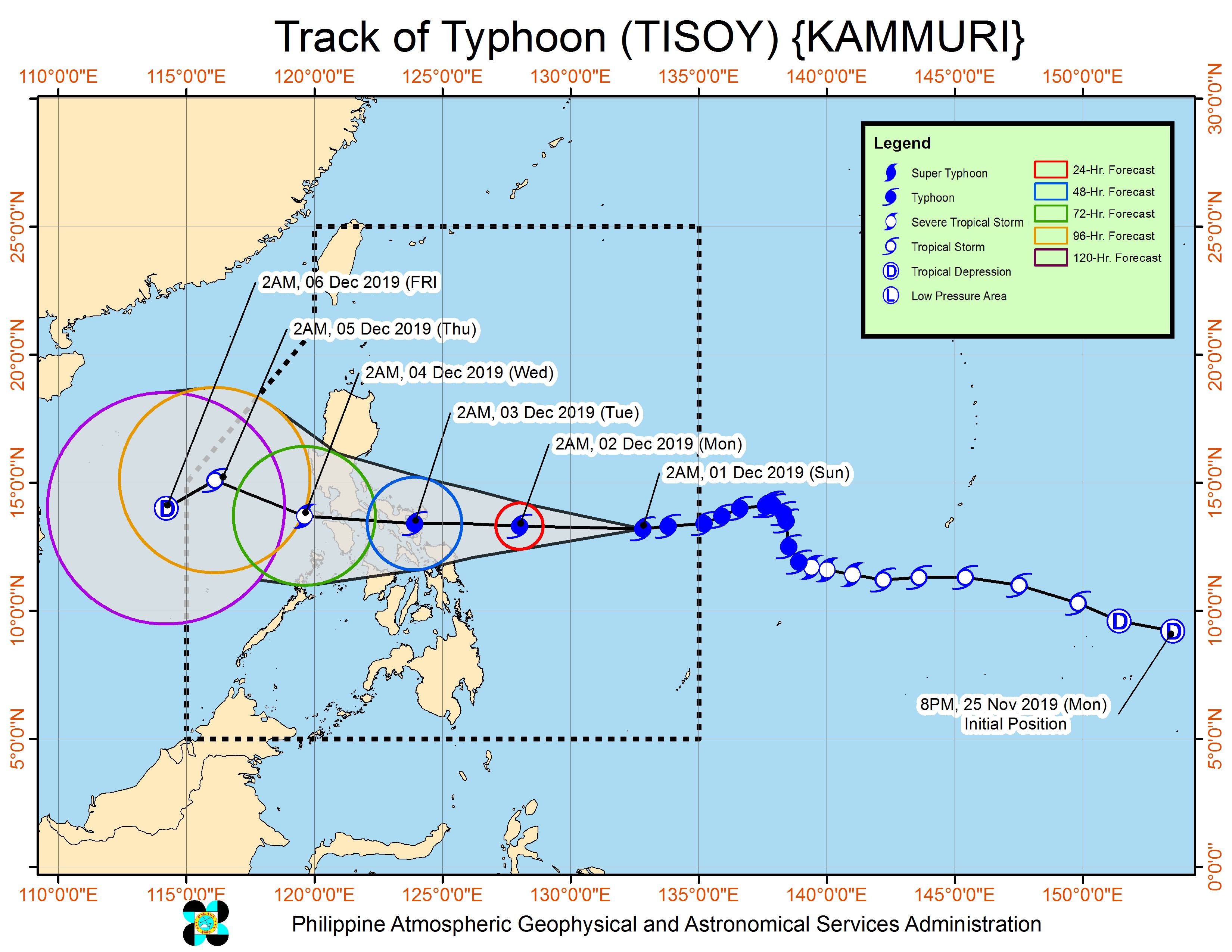
MANILA, Philippines – The powerful Typhoon Tisoy (Kammuri) maintained its strength before dawn on Sunday, December 1, en route to the region of Bicol.
In a bulletin issued 5 am on Sunday, the Philippine Atmospheric, Geophysical, and Astronomical Services Administration (PAGASA) said Tisoy is already 885 kilometers east of Virac, Catanduanes.
It is still moving west at 15 kilometers per hour (km/h).
The typhoon continues to have maximum winds of 150 km/h and gustiness of up to 185 km/h.
Tisoy is expected to make landfall in Bicol between Monday evening, December 2, and early Tuesday morning, December 3.
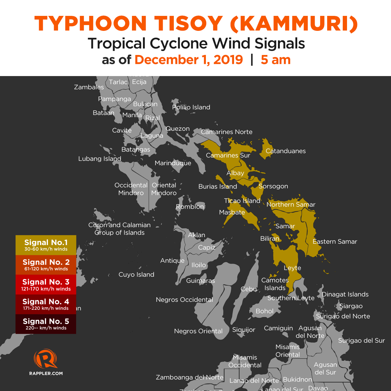
There are now 11 areas in Luzon and the Visayas under Signal No. 1:
- Catanduanes
- Albay
- Sorsogon
- Camarines Sur
- Masbate including Burias Island and Ticao Island
- Samar
- Northern Samar
- Eastern Samar
- Biliran
- Camotes Islands
- Leyte
This means winds of 30 km/h to 60 km/h may be experienced in those areas – not immediately, but 36 hours from when Signal No. 1 was first raised.
PAGASA has warned that Tisoy will bring strong winds which may be destructive.
Aside from strong winds, heavy rain from the typhoon is expected beginning Monday. PAGASA maintained this rainfall outlook:
Monday, December 2
- Occasional to frequent heavy rain
- Bicol
- Eastern Samar
- Northern Samar
- Samar
- Biliran
- Moderate to occasional heavy rain
- Romblon
- Marinduque
- Quezon
Tuesday, December 3
- Frequent to continuous heavy rain
- Metro Manila
- Bicol
- Calabarzon
- Occidental Mindoro
- Oriental Mindoro
- Marinduque
- Romblon
- Zambales
- Bataan
- Pampanga
- Bulacan
- Moderate to occasional heavy rain
- rest of Luzon
Those areas must stay on alert since Tisoy could trigger flash floods and landslides.
The typhoon is also looming over areas where events of the 2019 Southeast Asian (SEA) Games are set, particularly Metro Manila, Zambales, and Pampanga. The SEA Games opening ceremony was held on Saturday, November 30, with the regional meet set until December 11.
PAGASA previously said it is providing weather updates to the Philippine Southeast Asian Games Organizing Committee.
Travel is also risky, especially for small vessels, in the seaboards of areas under Signal No. 1, the northern and western seaboards of Northern Luzon, and the eastern seaboards of the Philippines.
Sea travel will be disrupted, especially if tropical cyclone wind signals have been raised in particular areas. (READ: FAST FACTS: Tropical cyclones, rainfall advisories)
Based on its latest forecast track, Tisoy is expected to leave the Philippine Area of Responsibility on Thursday evening, December 5.
Tisoy is the Philippines' 20th tropical cyclone for 2019, and the 4th for November. (READ: LIST: PAGASA's names for tropical cyclones in 2019)
The country gets an average of 20 tropical cyclones annually. In the earlier part of the year, only 14 to 18 tropical cyclones had been projected since 2019 is an El Niño year.
For the month of December, PAGASA is expecting 0 to 1 tropical cyclone.
PAGASA declared the start of the rainy season last June 14. – Rappler.com