KiwiRail has been quietly chipping away at a plan to dig a rail trench across the Auckland isthmus, lining up finance – and waiting for the right political environment to put its case.
Opinion: In the midst of a housing shortage, there’s something odd about the Auckland suburb of Onehunga. Walking through it, many streets have grassy lots, mostly empty, sometimes with just a relocatable house or two on them.
The big old map left behind by the previous owner when we moved into our home solves the riddle: the vacant lots combine into a swathe of yellow, cutting across the hilly neighbourhoods – a route designated for a freight rail line through to Avondale, joining up to the existing line through to Whangārei.
When I first discovered it in the middle of last year, I thought it was an anachronism. It had first been designated a rail route in 1946; in recent years KiwiRail has allowed the odd temporary building to be placed on the route, but always with the ability to move them off if necessary.
READ MORE: * How to build light rail, not bankrupt it * Auckland light rail's legacy of strategic confusion
Surely, nobody was still considering digging a big dirty railway trench across the Auckland isthmus, through the same communities that had already been chopped in half by the southwestern motorway cutting?
As it turns out, yes. KiwiRail had been quietly chipping away at this plan, lining up finance, and waiting for the right political environment to put its case.
That arrived when former Far North mayor Wayne Brown, a longtime champion of shipping freight through Whangārei rather than Auckland, was elected mayor of the Queen City.
Brown is no great fan of the Govt’s light rail plan through Mt Roskill, Onehunga and Mangere down to Auckland International Airport. But, presented with the opportunity to leverage the light rail to advance his heavy rail ambitions, he encouraged Auckland Light Rail to look at combining the two.
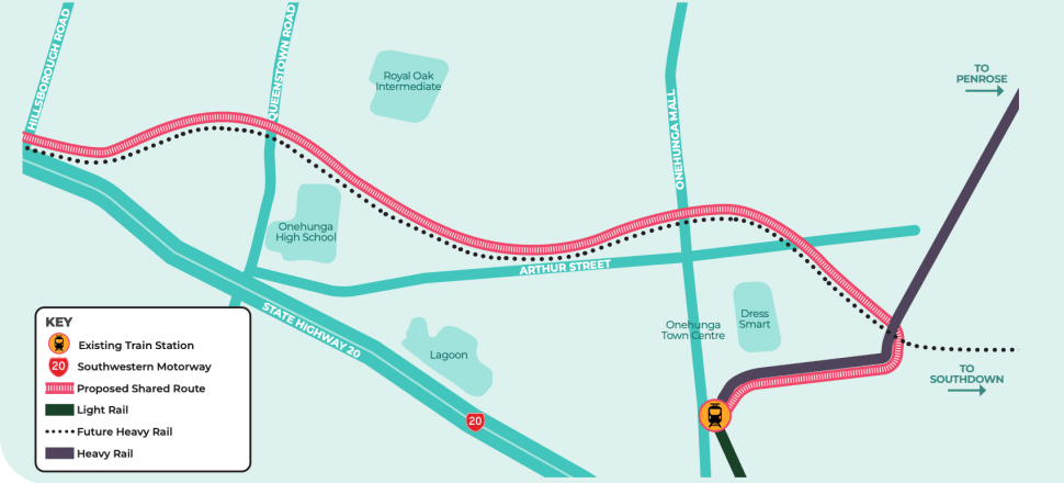
So, with a short consultation period that closed on Easter Monday, the community was asked to choose between two routes: the original light rail down the side of the southwestern motorway, or sharing the designated heavy rail route that cuts inland from Hillsborough Rd, slices across two schools, one historic Māori chiefly settlement site and the DressMart outlet shopping centre to join the existing Onehunga commuter rail line.
If this route is chosen, there is the potential for cost savings in running heavy and light rail alongside each other. The route could be tunnelled but that would be pricy; more likely authorities would opt for a cut-and-cover trench like the one that effectively shut down lower Albert St in Auckland’s CBD for most of the past five years, for the construction of the City Rail Link.
Yes, you may discern a degree of Nimbyism in my dismissive tone – but there’s a reason I raise this now.
Te Waihanga Infrastructure Commission has just published a research paper, Protecting Land for Infrastructure. It looks at how central and local government can make good decisions when we aren’t certain about the future.
It finds that designation or acquiring land for infrastructure in advance can make it cheaper and easier to build the infrastructure we need, from neighbourhood schools to major public transport routes.
"Our current ‘wait and see’ approach often means that valuable infrastructure doesn’t get built at all. By the time we need a new school or a better transport route, the right sites for that infrastructure are gone – they’ve got houses built on them," says Geoff Cooper, general manager of strategy at the commission. “Planning ahead and protecting sites in advance can break that vicious cycle.”
That’s certainly the case here. Even with the house price decline of the past 18 months, properties abutting this rail route are selling for $2m-plus. The cost of trying to buy up 80 to 100 such properties now, without the route designation, would be prohibitive.
The decision to be made will be a difficult one; the impact of cutting a trench through suburbia would be massive, on both the community, and the environment and (we now realise) the city’s vulnerability to flooding. But by designating the route back in 1946, the post-war planners have reduced both the cost, and the impact on 100 families who would otherwise have lost their homes today.
The commission’s report argues that protecting land needed for future infrastructure keeps NZ’s options open and can be easily reversed – we can sell the land if it is ultimately not needed.
“Developing infrastructure is a big investment and once built it will last for decades,” Cooper says. “Our findings suggest there are ways we can make better long-term infrastructure decisions – no matter what the future holds.”
But, on further questions from Newsroom, he adds a caution: “Advance site protection is a reversible decision in that land can be sold if it is ultimately not needed and it’s also flexible, for example, once a corridor is protected it might be used for a motorway, a busway, or a light rail line in the future," he says.
"There is always a risk of committing to a certain path too early, or not being willing to reverse a decision once more information becomes available."
Auckland's planners need to ensure they're not pursuing with tunnel vision a route designated after the war.


.png?w=600)