Tropical Storm Ian, which formed late Friday night over the southern Caribbean, is set to intensify into a powerful hurricane during the next few days.
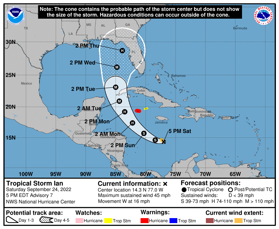
The big picture: The National Hurricane Center is now predicting Ian will develop into a Category 4 storm within the next 72 hours. Ian's path still is forecast to cross over portions of Cuba and then turn northward into Florida by midweek.
- Ian has an abundant supply of deep, warm water ahead of it, which computer models show is likely to help the storm rapidly intensify.
- In addition, starting later today, little significant wind shear is forecast to affect the storm.
- Shear occurs when winds blow in different directions or speeds with height, and it can prevent a tropical storm from intensifying.
Zoom in: As of 5 p.m. ET, Tropical Storm Ian was located about 255 miles south of Kingston, Jamaica, and was moving west at 16 mph. Maximum sustained winds were at 45 mph.
- A hurricane warning is in effect for Grand Cayman Island, while a tropical storm watch is in effect for Little Cayman Island. A previous tropical storm watch issued for Jamaica has been canceled as the storm is expected to miss the island at this time.
- The latest predictions released by the NHC show Ian making landfall somewhere along Florida's western coast on Thursday afternoon. However, the NHC warned Saturday that the uncertainty in the track forecast is higher than usual."
- "Regardless of Ian’s exact track, there is a risk of dangerous storm surge, hurricane-force winds, and heavy rainfall along the west coast of Florida and the Florida Panhandle by the middle of next week, and residents in Florida should ensure they have their hurricane plan in place, follow any advice given by local officials, and closely monitor updates to the forecast," the 5 p.m. advisory said.
Threat level: While computer models disagree on the track and precise intensity forecast beyond Monday, this storm poses a significant threat to Florida.
- The prospect of a major hurricane striking Florida in the next several days raises alarm bells, particularly because of the array of decisions that leaders must make in order to successfully evacuate vulnerable areas, such as the Florida Keys.
- In response to the approaching storm, NASA scrubbed its plan for Tuesday's Moon rocket launch from Cape Canaveral on Tuesday. It takes three days to move the massive rocket into the Vehicle Assembly Building.
- Florida Governor Ron DeSantis (R) has already declared a state of emergency for 24 counties that may be affected by the storm.
Between the lines: On average, hurricane track forecasts for days four and five have errors of about 150 and 200 miles, respectively, the Hurricane Center noted Saturday morning.
- The differences between computer models concern the strength and placement of a dip in the jet stream, also known as a trough, forecast to develop across the Central and Eastern U.S. early in the week.
- The European model has consistently shown the storm gaining strength and curving to the north-northeast over time, across western Cuba and into central or southern Florida late Tuesday into Wednesday and Thursday.
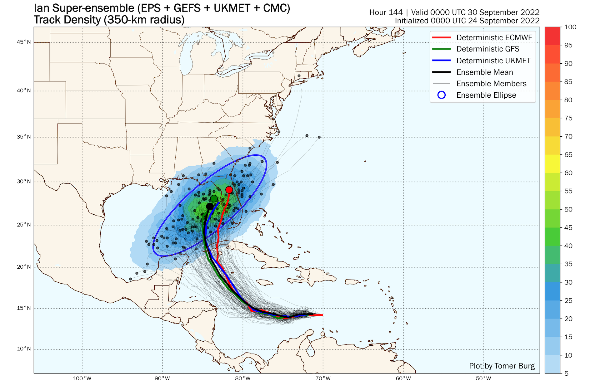
- The main American model, known as the GFS, has been depicting another scenario, with a weaker Ian making a later turn, and threatening areas further to the north in the eastern Gulf of Mexico.
- Forecasters with the National Oceanic and Atmospheric Administration (NOAA) are flying research aircraft into and around Ian to feed more data into the computer models, hoping to hone in on an accurate prediction.
Yes, but: The uncertainty notwithstanding, forecasters are urging Floridians to prepare this weekend for a potentially significant hurricane impact, with heavy rains, damaging winds and storm surge flooding.
- Millions of Floridians who flocked to the state in recent years may have never experienced a direct hit by a major hurricane, of Category 3 intensity or greater, particularly in vulnerable cities such as Tampa and Miami.
Context: Hurricanes are becoming more intense and damaging from human-caused climate change, which is enabling them to shed heavier amounts of rainfall and stay stronger further north.
- Sea level rise from melting ice sheets makes a hurricane's storm surge more harmful.
- In addition, there is an observed trend toward a greater share of storms in some ocean basins that reach the higher end of the intensity scale, and that rapidly intensify as well. However, the overall number of tropical storms and hurricanes is not expected to increase in a warming world.
- So far, the dire predictions for this Atlantic hurricane season have not panned out in terms of storm activity, but that seems to be changing, fast.