MIAMI _ As Hurricane Sally crept toward a very wet landfall in the Gulf, two tropical storms formed and one tropical depression dissolved Monday.
As of the 5 p.m. update, that left four named storms in the Atlantic, two disturbances to watch and one name left on the hurricane center's alphabetic list for the season. After Wilfred, storms will be named after Greek letters.
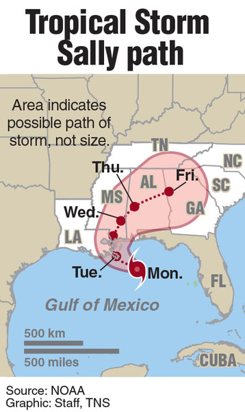
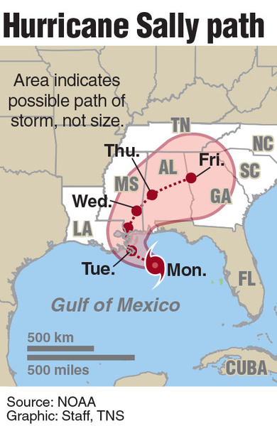
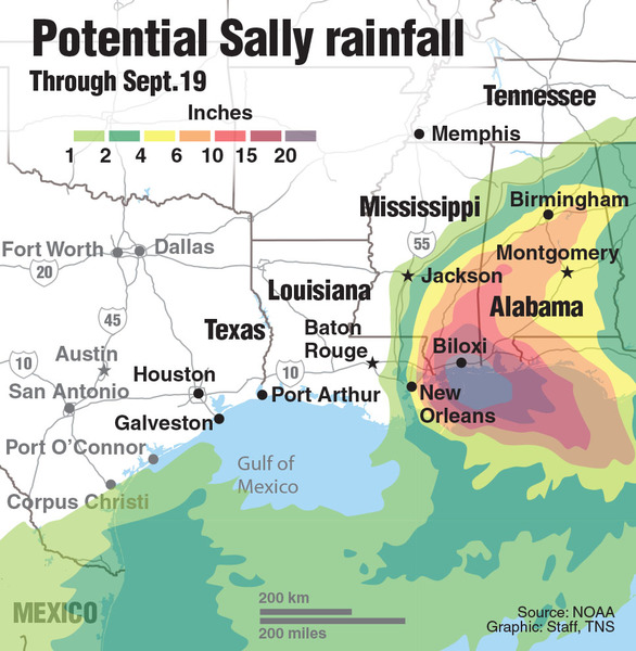
Sally rapidly became a Category 2 hurricane Tuesday afternoon, and forecasters warned it could strengthen further before landfall. But the real devastation could be in flooding. The hurricane center predicted that Sally could swamp Louisiana to the Florida Panhandle with storm surge and drenching rain. Some parts of Louisiana could see 11 feet of storm surge and up to two feet of rain.
The youngest storm, Tropical Storm Vicky, formed mere hours after Tropical Storm Teddy Monday morning.
Vicky, the 20th named storm of the season, was expected to be short-lived. As of the 5 p.m. update, it was about 350 miles west of the Cabo Verde Islands with 45 mph winds. The latest forecast showed it heading west this week as a tropical storm before weakening to a tropical depression far from land as soon as Wednesday.
Tropical Depression Rene, which also spent its short life deep in the mid-Atlantic and far from land, finally fizzled out for good Monday afternoon.
Hurricane Paulette spent most of Monday crossing Bermuda and pounding the island with 100 mph winds. By 5 p.m., the Category 2 storm was well north of Bermuda and all watches and warnings were discontinued.
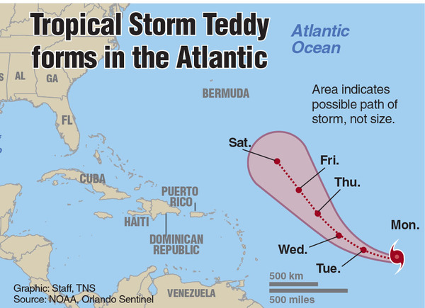
As of the 5 p.m. update, Tropical Storm Teddy was on track to strengthen into a powerful Category 3 hurricane, and its track led in the direction of Bermuda.
Teddy, which formed Monday morning, was about 1,170 miles east of the Lesser Antilles Monday evening. It was moving west-northwest near 14 mph with maximum sustained winds near 50 mph with higher gusts.
Forecasters said Teddy could strengthen into a hurricane as soon as Tuesday as the storm heads northwest toward Bermuda. The warm water, which is a few degrees hotter than average this year, is expected to help Teddy hit major hurricane-level strength by Thursday.
Large swells generated by Teddy are expected to reach the Lesser Antilles and the northeastern coast of South America Wednesday and will likely cause life-threatening surf and rip current conditions, according to forecasters.
As of the 2 p.m. update, the other two systems the hurricane center was tracking had slightly higher odds of forming.
A tropical wave that has yet to emerge off Africa's coast now had a 20% chance of forming in the next two days and a 50% chance of forming within five days.
The hurricane center said another low-pressure system in the southwest Gulf of Mexico now had a slim chance of strengthening _ 10% in the next two days and 20 in the next five.