Weather radar upgrade plans have been impacted in north Queensland as an unusual tropical cyclone looms.
Tropical Cyclone Jasper could intensify into a category five system on Thursday night as it moves toward the Queensland coast.
Currently a category three system, Jasper is the first tropical cyclone to form in Queensland waters in December in an El Nino year.
Its unexpected arrival has prompted the Bureau of Meteorology to re-think its weather radar upgrade plans in north Queensland, a region set to be impacted by Jasper early next week.
The bureau had taken its Mackay weather radar offline in June and was not expected to complete the upgrade until next week.
However senior meteorologist Laura Boekel confirmed the radar would be live by Friday with Jasper approaching.
"The Mackay radar is expected to return to service tomorrow," she told reporters.
Jasper's surprise appearance had already forced the bureau to shelve an outage at its Townsville radar.
The bureau had begun work to install new technology for the Townsville radar.
To complete their upgrade they had planned to turn off the Townsville radar during the day from December 11 to 18 and January 15 to March 8.
However Jasper's arrival has postponed the outage, Ms Boekel confirmed.
She said no one would be left in the dark as they awaited alerts with Jasper currently set to cross the north Queensland coast between Cooktown and Mackay.
"Decisions have been made to not turn radars off and to ensure they are back online as soon as possible, and that is this Friday," Ms Boekel said.
Jasper was located about 1300km from Cairns in the far north on Thursday.
It is forecast to reach a high end category four, potentially category five system overnight.
Over the weekend Jasper is likely to weaken but will remain as a tropical cyclone next week.
The bureau said at this stage the area most at risk of impact was between Cooktown and Mackay "including Cairns and Townsville mid-next week".
Ms Boekel warned the coastal region directly impacted by the cyclone may not be the only area affected.
"It may impact further away from where it is crossing," she said.
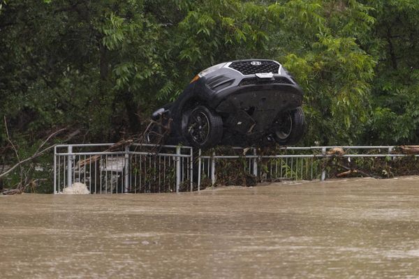
"We can see large impacts from tropical cyclones, especially when it comes to rainfall and flooding."
She said potential cyclone affects included storm surges causing coastal flooding, damaging or destructive winds and heavy, widespread rainfall.
The bureau will issue regular updates to keep communities informed.
Australia's cyclone season is usually from November to April, typically peaking in Queensland in February and March.