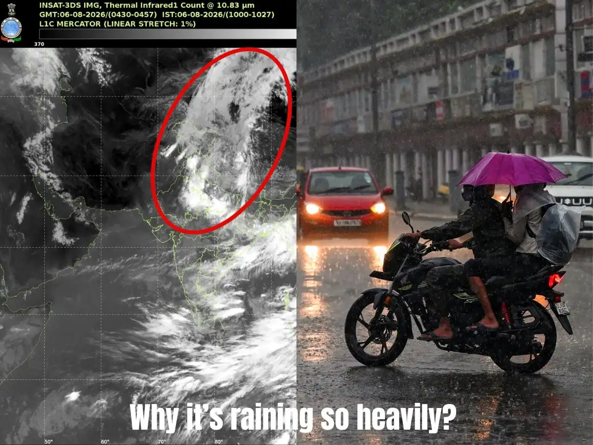
India's weather satellite INSAT-3DS has photographed a giant ribbon of white cloud running almost 3,500 kilometres, starting in western China, sweeping over the Tibetan Plateau and the Himalayas, and landing across north and central India. The picture, taken in the satellite's thermal infrared channel, looks like one massive weather system sitting across a continent. It's actually the joint handiwork of dozens of separate monsoon thunderstorms, all breathing out ice cloud at the same time.
Scroll through the INSAT-3DS image and the eye naturally reads it as a single arc of weather, curling from China down into India. But this is a canopy, not a storm. It sits high above a chain of thunderstorms buried within India's active monsoon, and the satellite is only seeing their tops.
Why the Brightest Clouds Are the Coldest Ones
Thermal infrared sensors don't photograph clouds the way a phone camera does. They measure temperature. The colder a cloud top is, the whiter it shows up in the image,and cold, in this case, means high. Some of these cloud tops sit 10 to 16 km up, brushing against the tropopause, the ceiling that marks the edge of the troposphere. That's roughly the cruising altitude of a commercial jet, doubled.
How a Thunderstorm Turns Into a Cloud Highway
Every big monsoon thunderstorm over northern and central India starts the same way: warm, wet air rockets upward. Eventually the storm hits its ceiling and can't punch any higher, so it does the next best thing, it spreads sideways, the way smoke flattens out under a glass lid. That spreading top is made of cirrus, thin sheets of ice crystals, and it's called an anvil for the shape it forms.
On its own, one anvil is unremarkable. But strong winds high in the atmosphere grab these ice sheets and drag them hundreds of kilometres from the storms that made them. When enough anvils get dragged in the same direction, they overlap and merge into a single unbroken sheet, which is exactly what INSAT-3DS caught stretching from the Tibetan Plateau into India.
The Winds Doing the Stretching
Two big wind systems are pulling this cloud band into shape. Over peninsular India, the Tropical Easterly Jet does the work. Farther north, stronger upper-level westerlies take over. Between the two, the cirrus outflow gets stretched and elongated into a band running past 3,000 kilometres, a scale that's more continental than local.
Also Read:Forget Nvidia chips, China's next big race is being slowed down by an unlikely rival: monkeys
Not a Cyclone, Not a Trough, Just a Very Busy Sky
It would be easy to mistake a cloud band this size for a cyclone or a monsoon trough. It's neither. There's no single low-pressure core driving it, no rotating storm system underneath. It's simply the collective signature of many monsoon thunderstorms firing at once, with their ice-cloud exhaust merging overhead. If anything, a cloud band this coherent is read as a good sign for the monsoon, it points to vigorous storm activity below and efficient venting up top, which lets thunderstorms sustain themselves rather than fizzle out fast.
What Happens Next
As long as the southwest monsoon stays active, expect more of these sprawling cloud shields to show up over South Asia in satellite feeds. They won't always be photogenic enough to make headlines, but the mechanics stay the same: storms rise, anvils spread, winds stretch them out, and for a few hours the sky over three countries looks like it's wearing one continuous cloud.