The tragic events in the Bay of Plenty this week are a stark reminder that landslides remain the deadliest of the many natural hazards New Zealand faces.
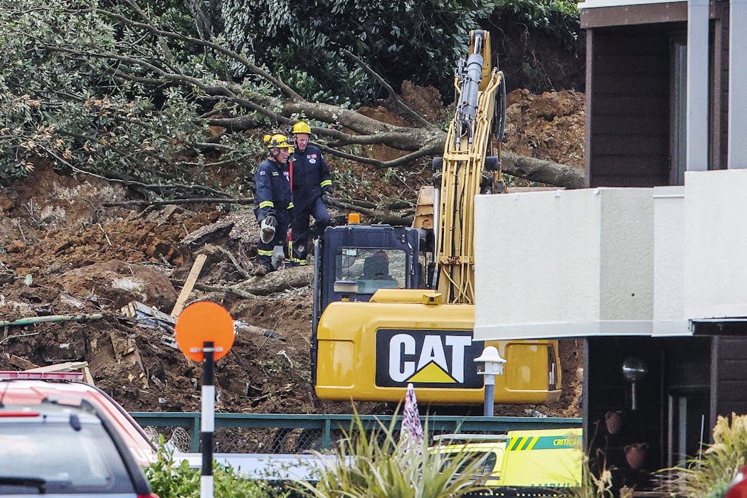
On Thursday morning, a large landslide swept through the Mount Maunganui Beachside Holiday Park at the base of Mauao, triggering a major rescue and recovery operation that will continue through the weekend.
Hours earlier, two people were killed when a separate landslide struck a home in the Tauranga suburb of Welcome Bay. As of Friday evening, six people remain missing at Mount Maunganui.
These events occurred at the tail end of a weak La Niña cycle, which typically brings wetter conditions to northern New Zealand. At the same time, unusually warm sea-surface temperatures have been loading the atmosphere with extra moisture, helping to fuel heavier downpours.
In parts of northern New Zealand, more than 200 millimetres of rain fell within 24 hours in the lead-up to last week’s events – well above the typical thresholds known to trigger landslides.
Regions such as the Bay of Plenty, Coromandel, Northland and Tairāwhiti are especially vulnerable to intense rainfall, which weakens surface soils and the highly weathered rock beneath them, allowing shallow landslides to detach and flow downslope.
Most landslides in New Zealand are triggered by heavy rainfall, through a complex interplay of intrinsic factors – such as slope angle, soil and rock strength, and vegetation cover – and extrinsic factors, including rainfall intensity and how wet the ground already is from prior rainfall when a storm arrives.
Much of this risk is invisible, accumulating quietly beneath the surface until a sudden collapse occurs.
This helps explain why landslides have long proved so dangerous. Since written records began in 1843, they have been responsible for more deaths than earthquakes and volcanic eruptions combined.
Much of New Zealand’s steep, geologically young landscape is pockmarked by the evidence of millions of past landslides, most occurring on pasture and remote areas, far from people.
When landscapes tell a story
At Mount Maunganui, the shape of the land itself tells a story. The surrounding hill slopes are riddled with the scars of past landslides, revealing a landscape that has been repeatedly reshaped by slope failure over time.
New high-resolution mapping now allows scientists to see this in unprecedented detail. A 2024 LiDAR-derived digital elevation model, which effectively strips away vegetation to reveal the bare land surface, shows numerous landslide features across the slopes.
Many cluster along the coastal cliffs, but two particularly large ancient landslides can be seen directly above the holiday park.
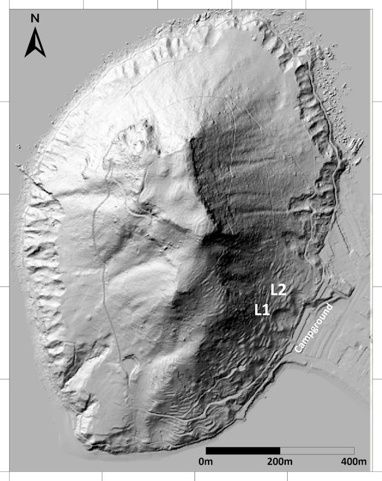
These older slips left behind prominent head scarps – steep, crescent-shaped breaks in the hillside – indicating where large volumes of material once detached and flowed downslope onto flatter ground below.
Subsurface evidence reinforces this picture. A geotechnical investigation carried out in 2000, near the northern end of the campground’s toilet block, found a 0.7 metre layer of colluvium – loose debris deposited by earlier landslides and erosion – buried beneath the surface.
In other words, the site itself sits atop the remnants of past slope failures.
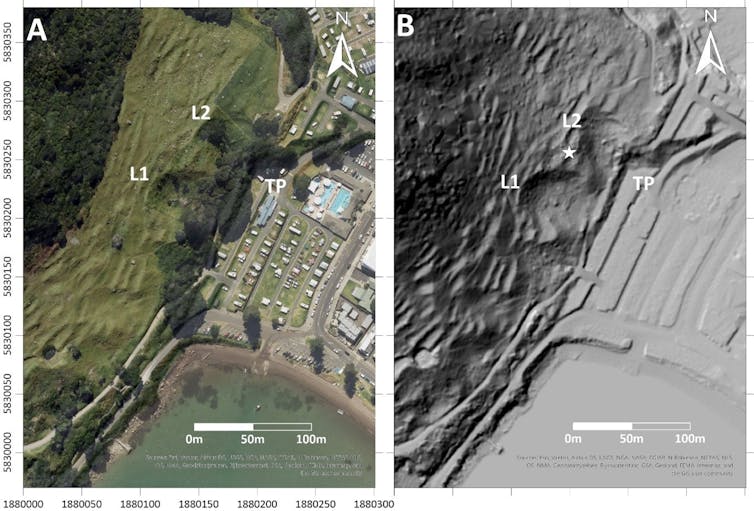
The January 22 landslide appears to have initiated in the narrow zone between the two earlier slips. This is a particularly vulnerable position: when neighbouring landslides occur, the remaining wedge of land between them can lose lateral support, becoming unstable, like a rocky headland jutting out from a cliff face.
Over long timescales, this kind of progressive slope collapse is a normal part of landscape evolution. But when it unfolds in populated areas, it can turn an ancient geological process into a human disaster.
From prediction to prevention
Predicting how far a landslide will travel, and which areas it might inundate, is critically important – but it remains an inexact science.
At its simplest, this can involve rough rules of thumb that estimate how far a landslide is likely to run based on slope height and angle. More sophisticated approaches use advanced computer models, such as Rapid Mass Movement Simulation (RAMMS) which simulate how landslide material might flow across the landscape.
These models were used, for example, to assess landslide risk at Muriwai, Auckland, following Cyclone Gabrielle.
By adjusting inputs such as rainfall intensity and soil properties, scientists can explore a range of possible scenarios, generating estimates of how far future landslides could travel, how deep the debris might be, and which properties could be affected.
The results can then be translated into landslide hazard maps, showing areas of higher and lower risk under different rainfall conditions. These maps are not predictions of exactly what will happen, but they provide crucial guidance for land-use planning, emergency management and public awareness.
New Zealand has made major progress in mapping floodplains, and most councils now provide publicly accessible flood hazard maps that influence building rules and help communities understand their exposure.
In the future, developing similarly detailed and widely available maps for landslide hazards would be a logical – potentially life-saving – next step.
Martin Brook receives funding from the Natural Hazards Commission Toka Tu Ake.
This article was originally published on The Conversation. Read the original article.