The Tharwa Bush Fair is on this Sunday. So much to see and do, from live entertainment to fun games for the kids. The little village wedged up against the hulking Mt Tennent and gateway to adventures in Namadgi and beyond is full of many surprises, and not just what you might pick up in the lucky dip.
Here are my top four things to check out while you're there.
Beautiful Bridge

Prior to the Tharwa Bridge, a punt operated to ferry passengers, supplies, passengers, and livestock from one side of the Murrumbidgee River to the other. Or if you really wanted to risk it, you could try to cross the unreliable ford.
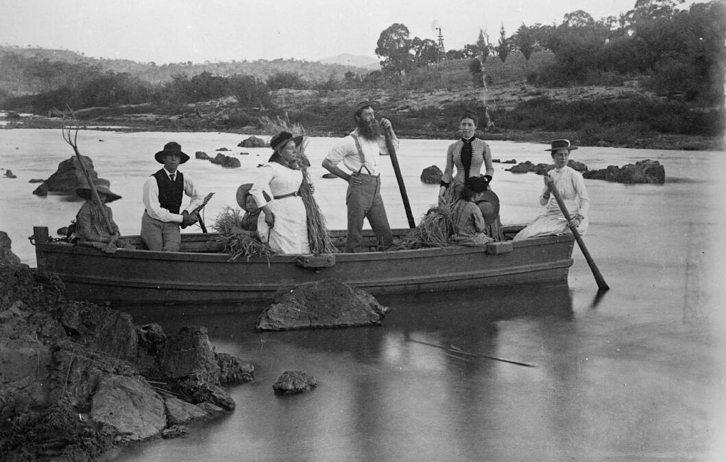
The punt was just 3.5 metres long and was used to transport Cuppacumbalong Station's (which back then made up most of present-day Tharwa) annual wool clip across the river. With about 300 bales per shearing season to ferry across, and only room for two or three bales per crossing, that was a heck of a lot of trips.
Meanwhile, the ford was subject to regular flooding and animals often became bogged in quicksand, so you can imagine the excitement when the single-lane timber truss bridge opened on March 27, 1895. In fact, it was such a significant event in the area that a localised public holiday was declared the day of the opening, when amid much pomp and ceremony, Mrs McKeahnie of Booroomba, the oldest resident in the district, opened the bridge by cutting a silk ribbon from which was suspended a bottle of champagne.
Apart from the markers on the bridge pylons indicating the height of each significant flood since 1895, my favourite part of the bridge are the pedestrian refuges built into each side of the bridge deck. Have you ever used them?
Curious cemetery
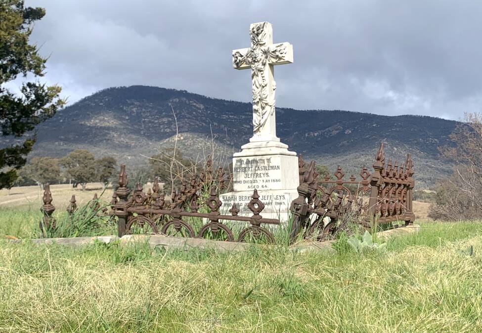
If you follow the walking track (called Tharwa Explorer Track on some maps) 1.4km upstream from the bridge, and through a stand of introduced Lombardy Poplars (spectacular in autumn), perched at the confluence of the Gudgenby and Murrumbidgee Rivers is the nearly 150-year-old De Salis Cemetery. This is the final resting place for 19 members of the De Salis family and employees of nearby Cuppacumbalong Station.
While family plots dating from the 1800s on rural properties are not unusual, this one, with its raised circular terrace, most definitely is.
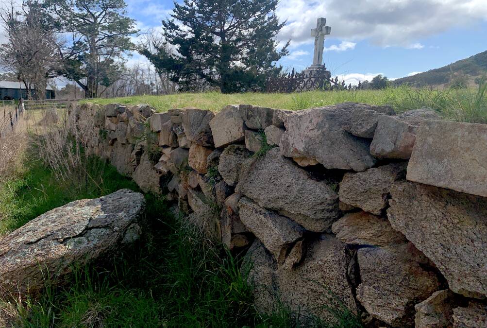
Due to difficulty digging through granite bedrock, when Charlotte De Salis died in 1878, the family decided that instead of digging down, to raise the cemetery up. Over many months they created an oval mound of dirt (sourced from the river) and surrounded it with high banks of stone and rock painstakingly hauled by horse and cart from the slopes of nearby Mt Tennent.
The track to the cemetery is mainly flat and regularly mowed and when I walked it earlier this week it was muddy in patches from recent rain.
Did you Know? In 1954, Queen Elizabeth II spent Valentine's Day with Prince Philip at Cuppacumbalong Station.
Sacred site
Meanwhile, downstream of the bridge, and still on the village side of the Murrumbidgee, is a short (only 100m or so) trail called Onyong track. Unfortunately, there is currently no interpretative signage, so the casual visitor would be completely unaware of its significance.
Onyong was an Ngambri warrior who assisted early pastoralist, Garrett Cotter (yes, after whom the Cotter is named), after he was banished in 1832 to the western side of the Murrumbidgee, beyond the so-called "limits of civilisation".
During his exile, Cotter learned bushcraft from Onyong and tales abound of the friends' escapades, including Onyong's risky swim across the flooded river to bring Cotter important news. Onyong's final resting place is a secret location not far from here.
When Onyong was shot dead in 1851 (a story for another column), William Davis Wright, whose family then owned nearby Cuppacumbalong Station, witnessed his burial at a location near this track. Many years later, Wright vividly recorded his memories of that day.
"The men of the tribe ... tied [Onyong's body] up in a complete ball ... His grave ... on the top of a rocky hill ... was about five or six feet in depth. A tunnel six feet in length was excavated and his body inserted, with his spears (broken in half), his shield, nulla nulla, boomerang, tomahawk, opossum rug and other effects. Then the hole was filled with stones and earth."
In a rather macabre, stomach-churning addition to this story, Wright further records that in later years a settler "with questionable taste" apparently "dug up the skull" and "made it into a sugar bowl".
Weird weirs
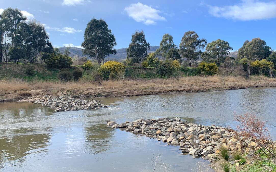
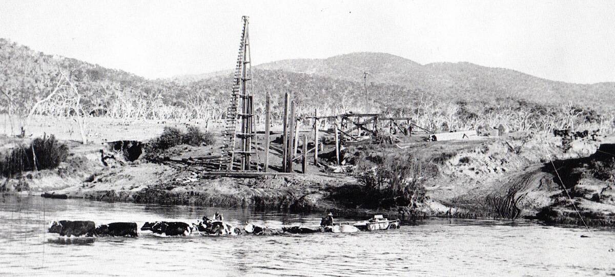
If you stroll a further 500-800 metres or so downstream of the bridge and past the locked road gate (called North Lane on some maps), you reach a series of prominent rocky structures that reach out into the water from both sides of the river.
Over recent years, this column has received several questions as to their purpose, some readers asking if they are the result of a broken weir or even a kayak slalom course.
They are rock groynes carefully designed by river managers to narrow the river channel through the Tharwa sand slug, an area where sand has built-up due to land clearing and erosion since European settlement. These narrow channels result in faster flow of water which scours the sand, thereby deepening the channel which in turn improves habitat and passage through the sand slug for threatened species of fish like Murray Cod and Macquarie Perch. Ingenious.
All the fun of the fair
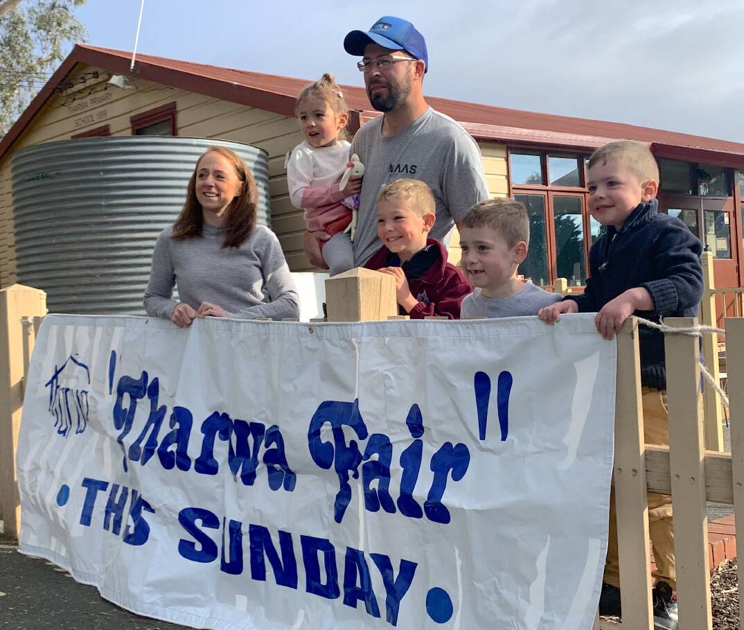
How many schools in Canberra can lay claim to five generations of the one family attending?
The Tharwa Preschool, home to the Tharwa Bush Fair, certainly can.
Take Elisa Rossiter, one of several dedicated P&C members running this year's fair whose son William attended in 2021 and younger son, James, will attend in 2024.
It was Elisa's great-great-grandfather Dan White Senior, who with then-teacher Fred Cleaver, lobbied the government back in 1908 calling for a new weatherboard building for the primary school which had previously been operating out of a slab hut. Fred even arranged for a wall to collapse during a visit by the inspector. It turned out to be a most successful strategy as a new building was subsequently erected in 1912.
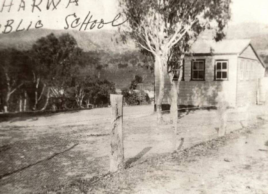
"And here we are, 114 years later, and we're part of a small P&C of mums (and by extension, dads) who are organising this year's fair to raise money for the little preschool to make sure it continues to thrive," explains Elisa.
"The fair has meant so much to the community for more than 60 years now, so we're thrilled to be able to bring it back this year and showcase the truly unique and wonderful preschool and village again."
After a two-year pandemic-induced hiatus, the bush fair, to be held this Sunday, September 18 (10am-2pm) features fun activities for children and families including sheep shearing demonstrations, the local fire brigade with fire truck, jumping castle and face painting.
If that's not enough, there'll be live entertainment, 25 stallholders selling locally made products, including, of course, a traditional country cake stall. And get this, free fruit for kids, thanks to Go Troppo.
Did You Know? As part of widespread school closures across the ACT, the primary school closed in 2006, but the preschool continues to operate on the site.
WHERE IN CANBERRA?
Rating: Medium
Clue: If you nailed last week's photo quiz, then you should get this one.
How to enter: Email your guess along with your name and address to tym@iinet.net.au. The first correct email sent after 10am, Saturday September 17, wins a double pass to Dendy, the Home of Quality Cinema.
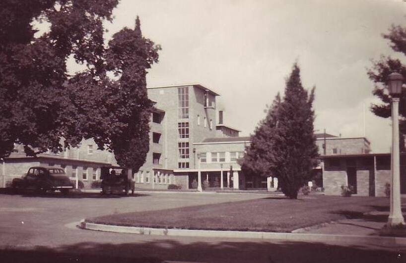
Last week: Congratulations to Rosemary Jennings of Dunlop who was the first reader to correctly identify the location as the entry to the Royal Canberra Hospital on Acton Peninsula, with the maternity ward on the left. The hospital opened on this site during World War II (the photo is from 1948) as an army hospital and then for civilians in 1943. It was demolished in 1997 to make way for the National Museum of Australia.
Rosemary pipped a procession of other readers, including first-time entrant Therese Kercher, Robyn Luck of Isaacs, and Frances McGee of Curtin.
The photo also brought back happy memories for many readers who were either born at the hospital or whose children were. These included Sigrid Horner of Deakin who reports her first daughter was born at the hospital and that the "pregnant" pencil pine (which still stands) was annually decorated as a Christmas tree.
Meanwhile, Michael Dwyer reports the area outside the hospital was "poorly lit and was the destination for young men driving their VWs frantically from places such as the village of Uriarra Forest before the baby arrived." And Michael should know as he had four children born at the hospital in the 1970s. Ah, the memories.
The sentiments of many readers reflected those of John Tokich of Taylor who was born in the hospital in the 1960s and was "sad to see it demolished on July 13, 1997". It was, of course, that botched demolition which resulted in the tragic death of 12-year-old spectator Katie Bender who was hit by flying debris.
SIMULACRA CORNER
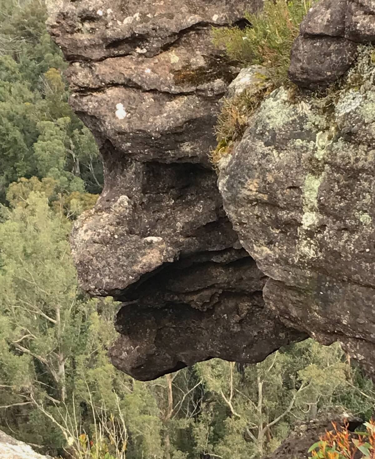
While on a recent bushwalk to Florence Head, a lookout north-west of Milton on the south coast, Barry Millar of Isabella Plains was stopped in his tracks by this cliff-top gargoyle. "Perhaps this is Florence's Head?" he quips. Love it.
CONTACT TIM: Email: tym@iinet.net.au or Twitter: @TimYowie or write c/- The Canberra Times, GPO Box 606, Civic, ACT, 2601