Temperatures are set to rise again this week after Britons basked in one of the warmest recorded starts to April.
Last Wednesday, 26.6C was recorded at Kew Gardens in southwest London, making it the hottest day of 2026 so far.
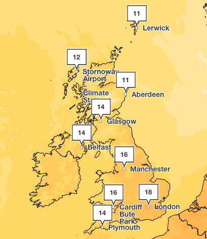
Following a cooler weekend, temperatures are expected to rise slowly and could reach 18C by Friday in London, and 16C in Manchester. Springtime temperatures are forecast into the weekend, with highs of 17C on Saturday and 16C on Sunday.
The news comes as forecasters suggest a brewing El Niño weather event could reach “super-strength”, further intensifying global warmth over the next year or so.
The term El Niño is used to describe the warming of the sea surface temperature that occurs every few years, usually in the central-east equatorial Pacific. When sea temperatures in the tropical region rise by more than 0.5C, the long-term average, an El Niño event is declared. El Niño is felt strongly in the tropical eastern Pacific with warmer-than-average weather.
The effects were seen in the US in March with unseasonal heat. March’s average temperature of 10.47C was 5.19C above the 20th-century normal for the month.
But these changes in the Pacific can have consequences across the globe, increasing the risk of drought in several regions, including India, parts of the western Pacific, northeast Australia, and the Amazon, according to the Met Office. They also often lead to reduced activity in Atlantic tropical cyclones.
A large El Niño would also increase the likelihood of elevated global mean temperatures in 2027, and could contribute to another year temporarily exceeding 1.5C above pre‑industrial levels on a global average basis.
“Our forecasts suggest it is likely to be a large event with sea‑surface temperature anomalies potentially exceeding 1.5 C in the central and eastern tropical Pacific,” a Met Office spokesperson said.
Europe and the UK can also be affected by this sea temperature change. It is likely to be less extreme than in the US, but El Niño has been linked to hotter summers and colder winters.
“It is important to stress that El Niño is just one of a number of climate drivers that can influence weather patterns in Europe and the UK. Any potential impacts will depend on how these drivers combine, and this will be assessed in more detail later in the year as forecasts evolve,” the Met Office added.
UK weather forecast this week
Wednesday
A cloudy and damp start for most, though it will brighten up as the day progresses, with some warm spells of sunshine developing. However, a band of heavy rain will also push eastwards, with heavy showers following from the west.
Wednesday night
Heavy rain quickly clearing to the east this evening, then a mix of clear spells and showers, these continuing overnight. Showers heaviest and most frequent in the northwest. Staying mild.
Thursday
A bright and breezy day, with sunny spells and showers. Showers most frequent in the north, some heavy with the risk of hail and thunder. Feeling warm in the sunshine.
Outlook for Friday to Sunday
Outbreaks of rain moving slowly eastwards through Friday, clearing the far east by Saturday lunchtime. High pressure building in behind this to give a dry and bright Sunday.
Michigan updates air quality alert system as wildfire smoke season approaches
Emergency managers issue warning for residents in tornado-prone areas
Supermarkets ‘taking the mickey’ on olive oil prices, Filippo Berio boss says
Alleged small boat pilot charged over deaths of four migrants in Channel
Army nurse sues MoD for £1.2m over colleague’s alleged ‘blackface’ gesture
Thousands of learner drivers to receive refunds over hidden fees