The Met Office named its first storm of the season as it issued several weather warnings across the UK over the weekend.
Storm Amy is expected to develop rapidly as it approaches the UK on Friday, bringing very strong winds and heavy rain to many northern and western areas. A number of weather warnings have been issued as 60 to 70mph wind gusts are expected inland, with wind speeds reaching up to 80mph along coastlines.
Met Office deputy chief meteorologist Tom Crabtree said: “Although there is still some uncertainty about the exact track Storm Amy will take, the system will bring gale force winds across northern and western regions, with gusts widely reaching 50 to 60mph inland in northern Britain, and potentially reaching 70 to 80mph in places. With even stronger gusts on exposed coasts and hills, mainly in the North West.
“Heavy rainfall is also expected, particularly over western Scotland, where totals could exceed 30 to 50mm in six to nine hours, increasing the risk of localised flooding. Forecasts and warnings will be updated as the situation becomes more clear, therefore it is important to keep an eye forecast for your area over the coming days.”
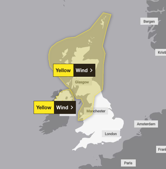
Yellow weather warnings for heavy wind have been put in place from Friday at 6pm, which will last late into Saturday night. The strongest winds currently look more likely over parts of northern Scotland, leading to difficult driving conditions for high-sided vehicles on prone routes such as crosswinds on exposed or high-level routes. Spells of heavy rain will also drench parts of western Scotland.
The winds will ease for most parts on Saturday afternoon, but will continue to be very strong for the Northern Isles and parts of the far north of Scotland through to the end of the day before slowly easing overnight.
Martin Thomson from Transport Scotland said: “Storm Amy is set to bring heavy rain and strong winds to parts of Scotland and we expect to see disruption to the transport network in the warning areas.
“The rain and wind will bring difficult driving conditions, such as reduced visibility and surface water, and are also likely to affect the ferry and rail networks, so it’s important to plan your journey ahead of time.
“Motorists should use the Traffic Scotland website before they set off to make sure that their route is available, and you should check with your operator if you are planning to travel on trains, ferries and flights.”
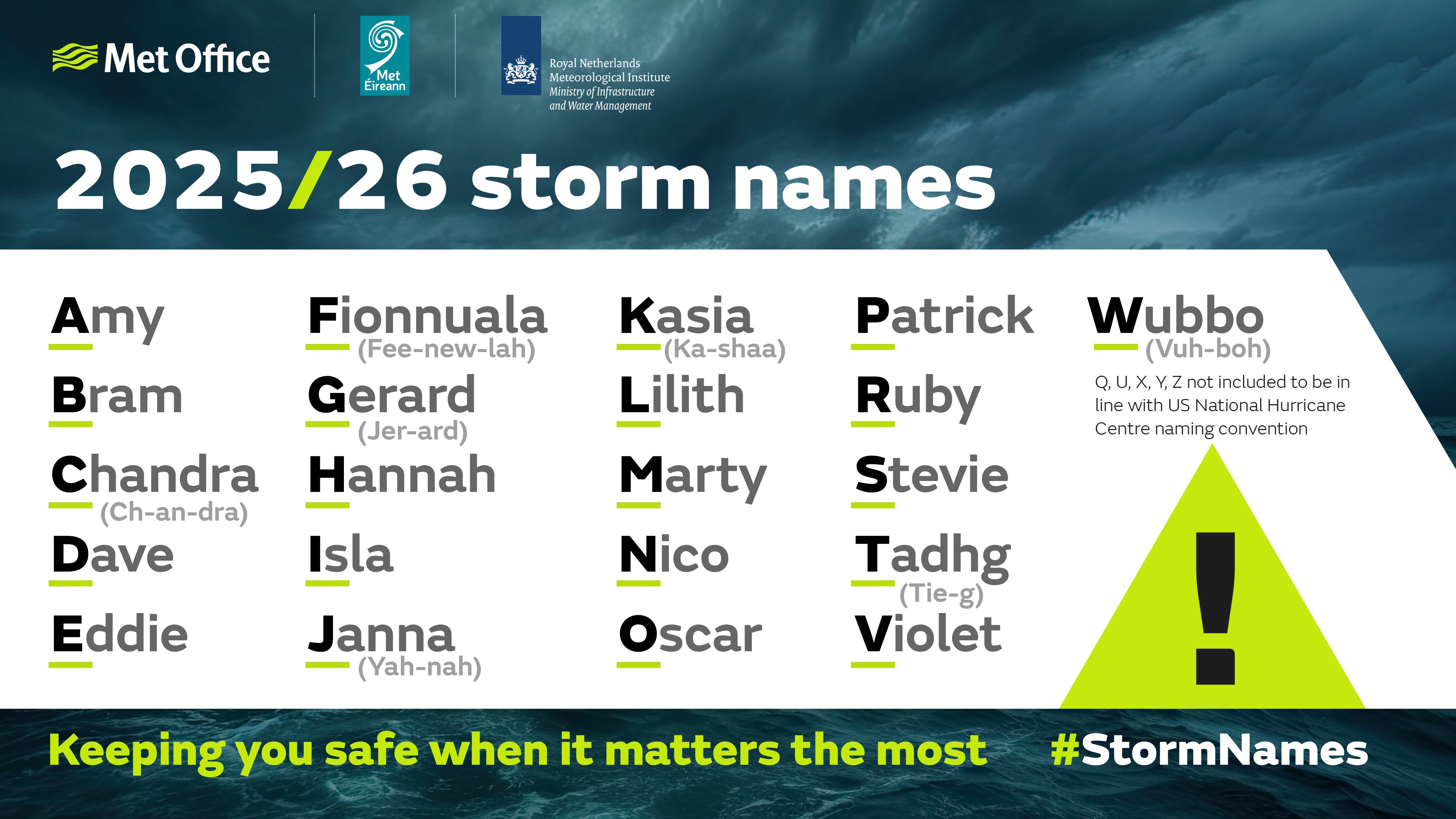
Storm Amy is the first storm named in accordance with the Met Office’s storm naming protocol cycle for 2025 to 2026, which aims to improve public awareness and readiness for impactful weather. Weather warnings are likely to be issued depending on the severity of the storm.
“The storm’s evolution is being closely monitored, with its development influenced by the remnants of Hurricanes Humberto and Imelda over the tropical Atlantic,” the Met Office said. “These systems have accelerated the jet stream, contributing to the formation and intensification of Storm Amy.”
Today:
Cloudy and rather breezy in the north with spells of heavy rain at first, easing for a time before heavy rain returns to western Scotland later. Dry elsewhere with early morning fog soon clearing to give way to sunny spells.
Breezy in the north with heavy outbreaks of rain in western Scottish, especially across the hills. Further south, remaining dry with patchy fog returning to the countryside under clear skies.
Thursday:
Widely cloudy in the North and West with rain becoming widespread and heavy by the afternoon. Dry in the South East with some sunshine, before cloud builds from the North West later.
Outlook from Friday to Sunday:
Briefly settled Friday morning, before becoming widely wet and windy later with heavy, persistent rain and coastal gales. Windy throughout the weekend with a mixture of sunshine and blustery showers.