The entire UK is covered by weather warnings as the Storm Amy hits, bringing gale-force winds of up to 100mph.
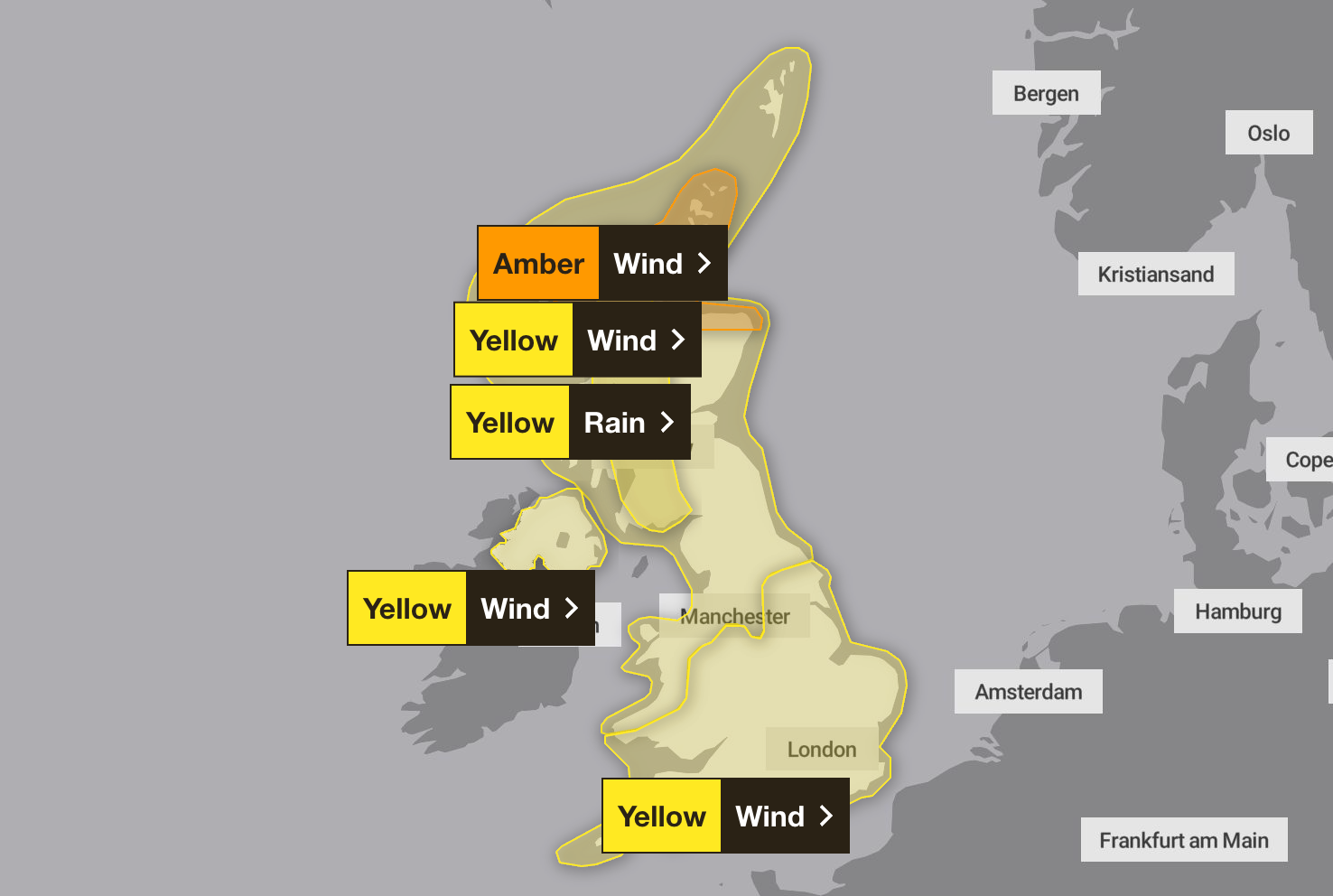
The Met Office had issued seven weather warnings ahead of Storm Amy, which brought “very strong winds and heavy rain” to northern and western areas on Friday, with all the country covered on Saturday.
A gust of 96mph was recorded overnight in the Inner Hebrides. An amber wind warning remains in place for parts of northern Scotland and the Met Office is warning of power cuts and flying debris that could endanger life.
A lower level yellow warning for winds has been issued for the rest of the UK until Saturday evening.
Met Office chief forecaster Neil Armstrong said: “Within the Scotland amber warning area, gusts in excess of 95mph are possible into Saturday morning as Storm Amy brings a risk of power cuts and damage to buildings and trees.
“Gusts up to 80mph are possible within the Northern Ireland warning area, more widely 60 to 70mph gusts are expected in the amber warning areas, in what will be an impactful autumn storm for many in Scotland and Northern Ireland.”
Irish police said the man died in a “weather-related” incident in the Letterkenny area of County Donegal, Republic of Ireland shortly after 4.15pm on Friday, after the Met Office warned residents to beware flying debris, road closure, and longer travel times in areas including County Antrim, County Fermanagh, County Derry, and County Tyrone.
A building collapsed in Glasgow on Friday, falling onto a car, and leading to road closures in the city centre.
Power cuts were also reported in the Highlands and a number of islands – the areas facing some of the worst weather.
Fraser Wilson from the Scottish and Southern Electricity Networks spoke on BBC Radio Scotland’s Good Morning Scotland programme where he said the network was working to restore power on Saturday morning.
He said that 100mph winds had affected power and while some people had their power restored there were still thousands without it.
Mr Armstrong said: “Rainfall is an additional hazard, in particular over western Scotland, where totals could exceed 30 to 50mm in six to nine hours, increasing the risk of flooding for some. Warnings will continue to be tweaked and amended in the coming days as confidence increases so stay up to date with the latest Met Office forecast and warnings.”
Storm Amy, the first named storm of the 2025-2026 autumn season. Stronger gusts are expected on exposed coasts and hills, mainly in the northwest.
Martin Thomson from Transport Scotland said: “Storm Amy is set to bring heavy rain and strong winds to parts of Scotland and we expect to see disruption to the transport network in the warning areas.
“The rain and wind will bring difficult driving conditions, such as reduced visibility and surface water, and are also likely to affect the ferry and rail networks, so it’s important to plan your journey ahead of time.
“Motorists should use the Traffic Scotland website before they set off to make sure that their route is available, and you should check with your operator if you are planning to travel on trains, ferries and flights.”

Here is the weather forecast for the UK for the coming week, according to the Met Office:
Saturday
Heavy rain clearing East to leave a day of sunny spells and heavy showers. Remaining very windy for most, with severe gales in the north. Feeling colder.
Outlook for Sunday to Tuesday
Blustery showers on Sunday, though the wind beginning to ease. Further rain likely in the north and west early next week, with drier interludes in the south. Feeling fresh.
Police question 6 suspects over deadly Manchester synagogue attack
Storm Amy latest: UK faces 100mph winds and heavy rain after man dies in Ireland
Storm Amy leaves 100,000 without power as cleanup under way in Ireland
British teenager jailed in Dubai killed in London car crash months after release
Police still questioning six as investigation continues into synagogue attack
Calls to widen police power to ban pro-Palestine protests after synagogue attack