As the clocks go back this weekend, cold Arctic air will cause temperatures to plummet across the UK, with the wintry conditions expected to bring the first snow of the season.
Showers of snow are set to fall across the Scottish mountains on Saturday, the Met Office said, as a “patchy frost” will cover England and northern Scotland on Sunday morning.
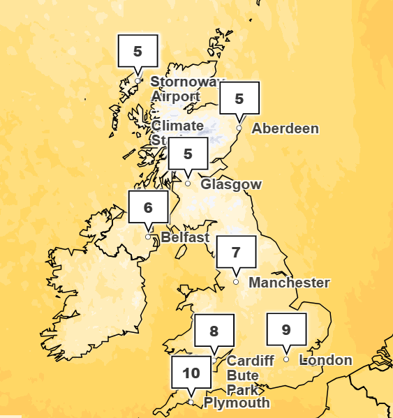
This weekend will also see the “coldest pair of days so far this season” with temperatures diving to single digits. The forecaster added that strong winds on Saturday will make the day feel like December, with a “brisk, blustery feel” making conditions feel several degrees lower.
“The combination of strong breezes and incoming, colder air means it will feel raw in exposed spots through daylight hours,” the Met Office said.
Frequent showers are also expected across Northern Ireland, northern Scotland, Wales and the South West.
An Atlantic low from the North West will give Saturday night a chilly feel, but Sunday morning will have “plenty of sunshine to begin with” across most central and eastern areas.
The Met Office said: “Eastern Scotland and the east of England may hold on to brighter skies into the afternoon.
“Elsewhere, cloud will increase, with a few early showers followed by a band of more persistent rain arriving around lunchtime for Northern Ireland, Scotland and western fringes of England and Wales.”
The cold weekend comes after Storm Benjamin battered the UK this week with heavy downpours and winds over 70mph.
Four yellow weather warnings were issued by the Met Office for Thursday, while over 40 flood alerts were in place in the morning.
UK five-day forecast
Tonight:
Showery rain will move southwards across much of the country through this evening and overnight, reaching south-east England by dawn. A mix of clear spells and scattered showers following from the northwest. Remaining windy and turning chilly where skies clear.
Saturday:
Remaining rather cloudy in the North East with some further rain at times. Scattered showers also moving into western areas, but mostly dry with sunny spells elsewhere. Another cold-feeling day.
Outlook for Sunday to Tuesday:
A mainly dry start on Sunday, but rain spreading in from the North West throughout the day. Remaining changeable early next week, especially in the North West, but temperatures gradually recovering.
Freeze and frost warnings hit more than 50 million American
First half of this year had record-breaking price tag for weather disasters
Storm Benjamin moves away from UK but wind and downpours set to continue
November 2025 payment dates for benefits and pensions plus cost of living support
Epping hotel migrant accidentally freed from prison boarded train to London
Prince Andrew latest: Andrew ‘in advanced talks’ to leave Royal Lodge